What is FeAST?
The Feature Activity Sensitivity Tool (FeAST) is a free online tool that generates first-pass environmental risk assessments for proposed developments and activities in Victoria’s marine and coastal areas
FeAST has been designed to support planning and approval decision-making processes under the Marine and Coastal Act 2018 and Environmental Effects Act 1978. The tool was publicly released in May 2023 and aims to promote the sustainable use of the marine environment and protection of key natural values.
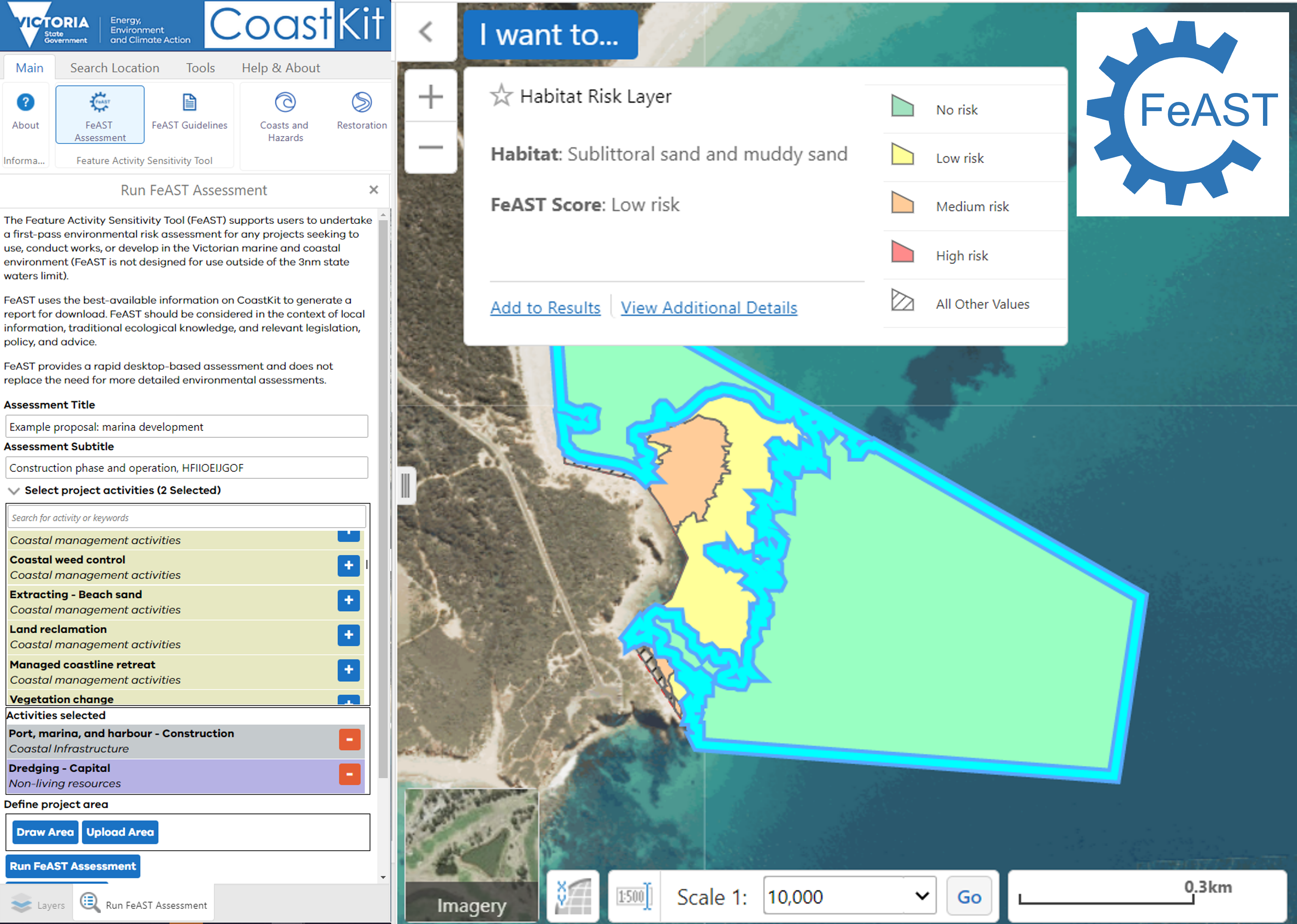
FeAST is easy to use and publicly available on CoastKit. The tool uses the best-available information found on the web-mapping portal to produce a standardised report that is readily downloadable in 30 seconds.
Online guidelines have been developed to assist users with operating the tool and interpreting the FeAST outputs. To access the guidelines use the left-hand side contents menu to navigate between pages.
Introductory video on FeAST
Purpose of FeAST
Maritime-related industries, developments, and activities are increasing across the globe. Assessing the environmental impacts of these developments is often challenging, time consuming and ad-hoc.
FeAST supports proponents and decision makers to quickly collate desktop-based information to preliminary screen environmental risks. The FeAST report should be used to identify avoidance or mitigation measures or highlight the need for additional scientific evidence.
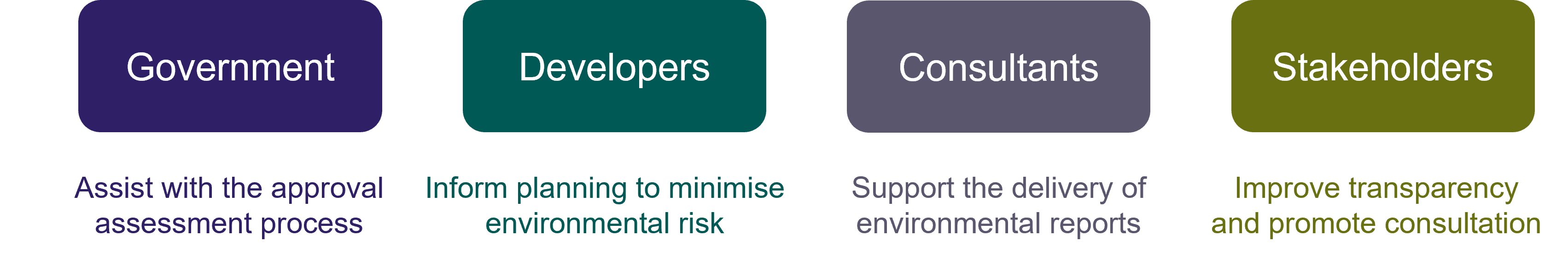
The main user groups include state and local government planners, developers, consultants and land managers.
How to use FeAST?
FeAST is easy to use and operates within CoastKit to systematically generate a report which presents the likely affect selected activities may have on habitats within the footprint of the proposed project. The report also includes a section which lists priority features, key environmental values and other activities that may occur within the vicinity of the defined project area.
FeAST provides a first pass risk assessment to better inform further investigation and planning, but does not replace the need for more detailed assessments. The FeAST report is requirement for all Marine and Coastal Act 2018 consents and supports relevant stages of the Environmental Effects Statement (EES) process.
Steps to run FeAST:
The below steps outline how to run the FeAST assessment using the online tool.
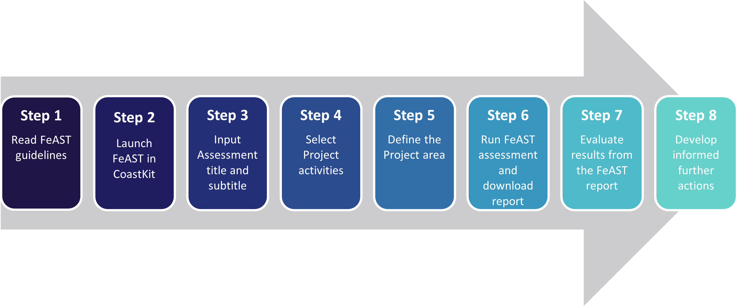
- Step 1. Read the Introduction to FeAST and the FeAST assessment process to understand the capabilities, outputs and limitations of the tool.
- Step 2. Open FeAST in CoastKit and consult the FeAST user guide for detailed information on how to use the tool.
- Step 3. Input the Project name, stage, or location in the Assessment title and subtitle boxes.
- Step 4. Select the Project activities from a list of 130+ activities grouped by 12 sectors (for full definitions refer to Supporting information).
- Step 5. Draw or upload the Project area ensuring the footprint of the proposal is accurately represented.
- Step 6. Run FeAST Assessment to generate the FeAST report available for download.
- Step 7. Examine the Pressure, Habitat, and FeAST scores, the Marine Biodiversity Values analysis and the Proximity analysis results. Consult the Using the FeAST report pages.
- Step 8. Develop further actions as informed by the FeAST results, which may include: relocating a project, undertaking field surveys and data acquisition, creating an environmental management plan, modelling impacts, evaluating cumulative impacts, developing a full impact assessment or proposing mitigation measures.
To learn more about FeAST please read the web version of the guidelines or the full document available for download below:
PDF version of the FeAST guidelines.
If you have further questions about FeAST please contact us at Coastkit@delwp.vic.gov.au
Page last updated: 22/10/25