Using the FeAST report
This section has been written for all user groups engaged in the pre-application, application submission or application assessment stages of project planning and approvals. FeAST is a key tool in the referral stages of a project; however it does not replace the need for more detailed and bespoke assessments as required for an EES or no-EES with conditions assessment.
FeAST provides a first-pass environmental risk assessment that compiles existing and publicly available information in the form of a desk-based study to highlight the potentially significant impacts to habitats that could arise from a project. FeAST also identifies important features that need to be considered, that are either present or potentially present within a site or the surrounding area.
FeAST assessment should be used at the outset of the project in either the initial project design phase or preliminary screening stage and does not replace the need for a full environmental impact assessment, or environmental audit. FeAST provides a sub-set of the pre-existing and relevant background information that could be used to inform site and activity selection, and determine which species, ecosystems, habitats, or environmental features are likely to require a detailed assessment.
The results generated by FeAST are particularly applicable to the initial negotiation stages between a project proponent and planning authority, and can assist with discussion to:
- Evaluate the significance of ecological issues identified by FeAST in determining an application for planning consent.
- Establish requirements and conditions prior to approving planning consent applications.
- Define the appropriate scope and content of a subsequent detailed environmental impact assessment.
- Determine the proposed survey design and methods for survey, evaluation, and assessment.
- Decide on strategic plans of sustainable development to allow for various uses.
FeAST is a first pass risk assessment and does not replace the need for more detailed environmental or ecological assessment. The FeAST assessment report can also support requirements under the following legislative and policy framework objectives, with more detailed information in the below section on Interpreting the FeAST report and scores.
- The Environment Protection Act 2017, support General Environmental Duty (GED): the responsibility of the user to reduce the risk of harm posed to the environment.
- The Flora and Fauna Guarantee Act 1988, which ensures the conservation of threatened species and communities, and for the management of potentially threatening processes. The project must consider the conservation objectives as outlined in Protecting Victoria’s Environment- Biodiversity 2037. The plan aims to stop the decline of Victoria’s biodiversity and achieve a net improvement in the outlook across all species over the next 20 years.
- The Marine and Coastal Act 2018, which provides objectives and guiding principles for planning to protect and enhance the marine and coastal environment.
- The Environment Effects Act 1978 applies to projects with the potential to have a significant effect on the environment.
FeAST adopts the Australian Standards for Environmental Risk Management and can assist with the preliminary screening of risks. It can also be used to rank and prioritise which risks require further investigation and analysis due to unacceptable levels of change, harm, or impact, additionally FeAST can indicate where there is insufficient data available and uncertainties. It is recommended that the Australian Standards for Environmental Risk Management framework should be applied by users after using FeAST to establish the context for the risk assessment process. The figure below shows the risk assessment process (AS/NZS 4360:2004).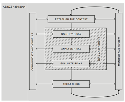
Additionally the following risk management principles are recommended to guide the user with a sequential process if a high or medium FeAST score has been attained (CIEEM, 2018):
The proponent should evaluate multiple site options and explore the most-suitable timings for project activities to avoid harm to sensitive habitat at risk and environmental features within close vicinity.
The proponent must provide solutions for avoiding, minimising, or managing potentially negative impacts as highlighted in the Pressure Score section of the FeAST report. The pressures should be used to inform the design of the project or produce options for mitigation measures, in addition to best-practice guidelines.
In cases where potentially negative impacts are unavoidable or residual ecological effects persist, it is a requirement for a compensatory offset as per planning conditions.
Depending on the significance of the impacts posed by the project, the proponent should demonstrate suitable measures to improve the health, condition or extent of habitats or at-risk environmental features identified within the vicinity of the project area.
FeAST can be applied to projects of varying scales, however the level of detail required by regulators and planners will be proportionate to the scale of the development and the complexity of potential impacts posed by the project.
1. User Checklist
A checklist has been created to support using the FeAST report and to inform next steps. Use the list below to find more information and which section to navigate to on this page.
2. Quality Assurance process
Has the FeAST report been checked for accuracy?
3. Interpreting the FeAST report and scores
Have the results from the FeAST assessment been addressed?
4. Traditional Owners' rights, aspirations and knowledge
Have Traditional Owners’ rights, aspirations and knowledge been considered appropriately?
5. Key legislation and policies
Have all relevant policy, plans and legislation been accounted for?
6. Supplementary information
Has all relevant information from other data sources been considered?
7. Avoiding locations
Have alternative locations been considered?
8. Undertaking field surveys
Have any surveys been undertaken, and information provided to decision makers?
9. Seasonal considerations
Has the user explored the most suitable time of year and day for project activities to occur?
10. Climate change and sea level rise
Has climate change or sea level rise been considered in context of the location and activities of the proposal?
11. Zones of influence
If applicable, has modelling been conducted to consider the zone of influence?
12. Cumulative effects
Have integrated impacts and cumulative effects associated with the project activities and other nearby existing or emerging activities been considered?
13. Developing mitigation measures
Have appropriate mitigation measures been developed and what is the anticipated risk level after implemented?
14. Submitting the FeAST report
Has the report and associated files been sent to the relevant decision maker?
2. Quality Assurance process
The FeAST report presents information in a way that is transparent and allows for rapid appraisal and review of information. The user must ensure that all the information provided in the report is accurate and not misleading. It is the responsibility of the user to undertake a quality assurance process to ensure all activities that will occur as part of the project have been accounted for and the defined project area is an accurate representation of where all the activities will occur.
The checklist below should be used as a process for ensuring the information in the report is correct:
Is the defined project area (combined if multiple polygons) accurate and comprehensive, including all the activity footprints or ancillary works associated with the proposal? | |
Do the activities selected best describe the project and all the activities planned to occur during the lifecycle or duration of the project (i.e. construction, operation, maintenance, or decommissioning)? |
3. Interpreting the FeAST report and scores
The FeAST score provides the level of risk to each habitat identified using the project area and activities.
The FeAST score represents the risk of irrecoverable impact to a habitat and indicates the need for further action. The FeAST score addresses risk concepts of likelihood vs consequence, framed by FeAST as the level of exposure vs the sensitivity of the habitat (see the Technical summary page).
It is important to note FeAST is based on semi-qualitative information and provides only a preliminary prediction of risk, and several limitations apply (see the Introduction to FeAST page).
The Australian Standard for Environmental Risk Management places risk into three categories:
- Risks that are at an acceptable level, and do not need to be considered further.
- Risks that are currently too high to be acceptable, and for which risk treatment measures must be considered to bring them to an acceptable level. These risks are sometimes referred to as ‘tolerable’, because they are tolerated under specific circumstances or for a specified time.
- Risks that are unacceptable in any circumstances or at any level (intolerable).
The interpretation of the FeAST results is based on the concept of acceptability. The table below present the potential ecological effect, the assessment interpretation and user recommendations based on the FeAST score and acceptable level of risk criteria.
| FeAST Score | Potential ecological effect | FeAST assessment interpretation | User actions |
|---|---|---|---|
High risk | A permanent functional, structural, or ecological change in character of a habitat at an ecosystem scale is likely. | A high possibility that the project activities will pose irrecoverable harm to a habitat type. With the current information available this would be considered an unacceptable level of risk. | Further investigation is likely needed to understand the full extent of possible impacts to the habitat and broader environment. Based on the available data from the FeAST assessment consideration needs to be given to changing the location and/or activities. Decision-makers need to be satisfied the impacts have been avoided, minimised, mitigated, and sufficient evidence must be provided to support this and to show thorough consideration of local information, indirect or cumulative impacts, and relevant legislation. |
Medium risk | Habitats may take a prolonged time to recover with significant mortality of keystone and characterising species leading to populations and communities shifting a distinct level. | A moderate possibility that the project activities will pose serious harm to a habitat type. With the current information available this would be considered an unacceptable level of risk. | |
Low risk | Some noticeable changes in the physicochemical character of a habitat and mortality of species possible with a small reduction in the overall extent of the habitat. | A low, but existing possibility that project activities will pose serious harm to a habitat type. With the current information available this would be considered an unacceptable level of risk. | Additional information may be required based on the results of the Proximity analysis. Evidence should be provided to show consideration of local information, indirect or cumulative impacts, and relevant legislation. |
No risk | No significant effects to habitats | A negligible possibility that the project activities will pose serious harm to a habitat type in this location. However local information, indirect or cumulative impacts, and relevant legislation may deem this level of risk unacceptable. | |
Not evaluated | Significant data gap or uncertainty. FeAST has no mapped data for coastal and terrestrial environments, and Commonwealth Waters (> three nautical miles) | Insufficient data available to determine if project activities will pose serious harm to a habitat type. | Further investigation is required to identify potential risks to the habitat. Additional information may be required based on the results of the Proximity analysis. Evidence should be provided to show consideration of local information, indirect or cumulative impacts, and relevant legislation. |
The FeAST score should only be adopted as first-pass or preliminary risk assessment due to the limitations (see Introduction to FeAST page), with the potential for the level of risk to increase depending on project, location, project impacts outside of the footprint, temporal specific factors, and other environmental values like migratory species.
The habitat map accuracy and survey effort (i.e. number of ground-truthed biotope records; see Supporting information page) across the state and displayed on the biotope atlas, should be taken into consideration when interpreting the FeAST scores and deciding on further actions.
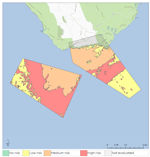
The figure below is from an example FeAST report showing a set of project activities that have triggered a low, medium, and high-risk FeAST score across the 8 identified habitats present in the project area and Cape Otway biounit. The spatial depiction of risk helps users look to avoid specific habitats and should be used to inform further actions.
Using Habitat scores
When a high, medium or low FeAST scores have been attained, the user should also look at the Habitat score results and individual sensitivity scores. The Habitat score section in the report depicts the sensitivity of each habitat to all the pressures likely to occur during the duration of the project.
The Habitat scores can inform the selection of appropriate avoidance, minimising, and mitigation measures and whether proposed measures are appropriate. It is recommended to highlight habitats with a high to medium sensitivity. The below example shows an extract from the FeAST report where a user has circled sensitive habitats.
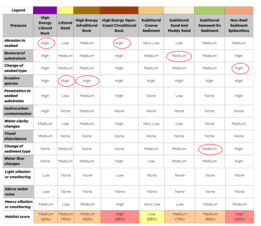
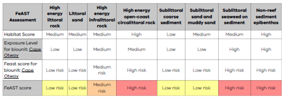
The Habitat score does not account for the location of the project or the proportional exposure as calculated within the biounit. The sensitivity relationship is always the same between the pressure and the habitat. The scale of the project and the location across the state is considered in the FeAST score, as seen below in the table.
Using Pressure scores
Additionally, the user should analyse the results from the Pressure score even if the FeAST score has not presented a high or medium risk.
The Pressure score synthesises all the pressures likely to be exerted by the activities regardless of habitat type. This provides an indication of impact to other environmental features, assets, or even humans.
The below image shows 18 pressures with a high to medium likelihood to occur from all the proposal activities. Some of the pressures identified will pose minimal or no threat to habitats these include ‘electromagnetic changes’, ‘visual disturbance’, ‘litter’ and ‘above water noise’.
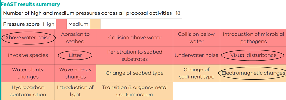
However, these pressures may still need to be avoided, minimised, or mitigated to avoid impact to fauna and people. This summary provides useful information for developing robust mitigation measures around each pressure. More information is below in section 13.
The Pressure score results can also be used to evaluate the potential pressure cause-effect pathways across different user-selected activities. This information can be used to explore and screen other activity alternatives or project options to minimise pressure-induced impact pathways.
The scoring is based on a standardised list of benchmarks for each pressure that assumes compliance to thresholds or objectives set by legislation or best-practice frameworks. The user is required to consult the Supporting information page to ensure their project is aligned to nationally and state-wide adopted values. Additionally, the project should consider the context of local conditions.
The Pressure score results should also be considered with information in the Proximity analysis tables.
Using Marine Biodiversity Values (MBV) results
The MBV analysis supports project planning by identifying priority avoidance areas of high biodiversity value, helping to guide site selection and minimise ecological impacts. The assessment also provides a list of species likely to occur within the proposed activity area, including their conservation status and spatial overlap, which can inform decisions about potential risks and the need for further ecological investigation.
High biodiversity values (ranked closer to 100 on the MBV map) indicate areas that:
- Support many different marine and coastal biodiversity features.
- Contain rare, listed, or irreplaceable species and habitats.
- Are ecologically significant, with few or no other locations having the same combination of features.
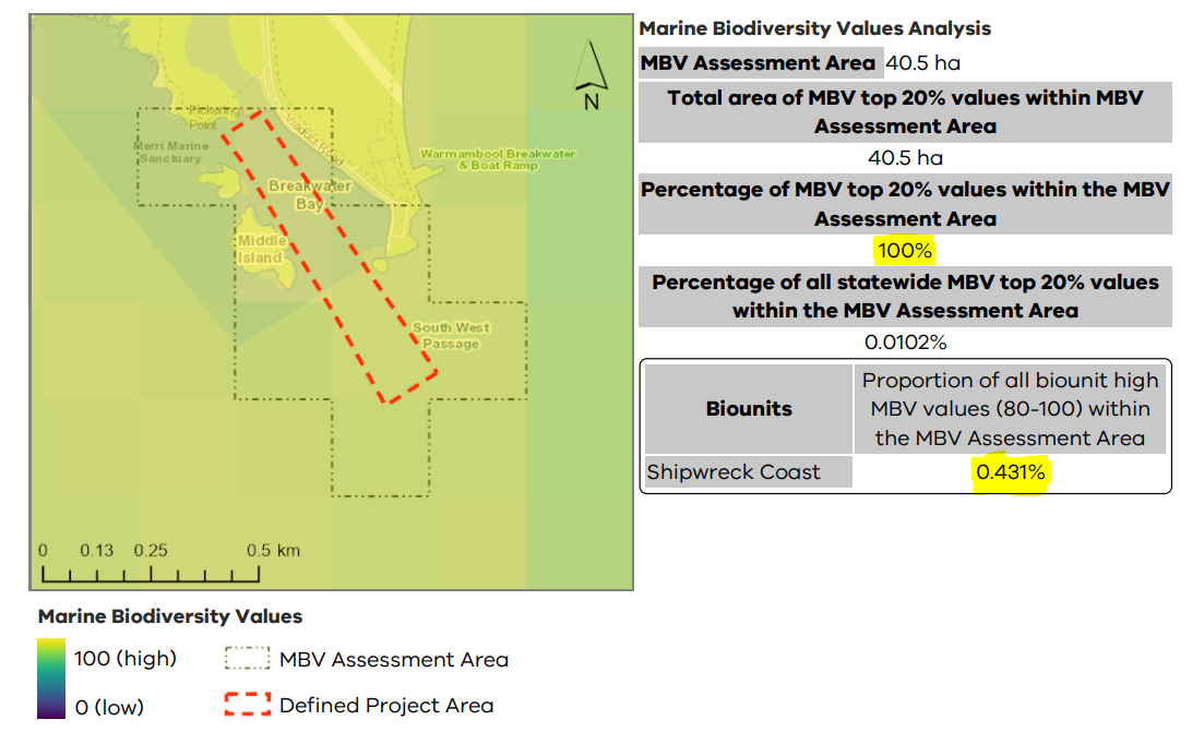
In the MBV Spatial Assessment, it is recommended that a project at the site level should aim to avoid areas with high biodiversity value, ranked between 80-100 (the top 20%), which are shown as yellow on the MBV map. The assessment also enables users to understand potential impacts on a regional scale, as presented by the biounit proportion and statewide proportion.
For example, in the case study below, 100% of the total MBV Assessment Area overlaps with high biodiversity value zones, while the proportional overlap at a biounit scale is less than 0.5% intersection with high biodiversity values. Additionally, the map below shows that the 55% of proposed area intersects with the "Merri Marine Sanctuary", which is subject to strict controls on activities under Victorian legislation. Therefore, it is important to consult the Proximity analysis section and relevant regulatory frameworks to assess potential constraints and determine whether further investigation or approvals are required.
These statistics should be evaluated on a case-by-case basis, depending on the nature and scale of the proposal, to determine the level of acceptable change. This should be conducted in alignment with relevant legislative frameworks and obligations to help to establish thresholds for significant impact.
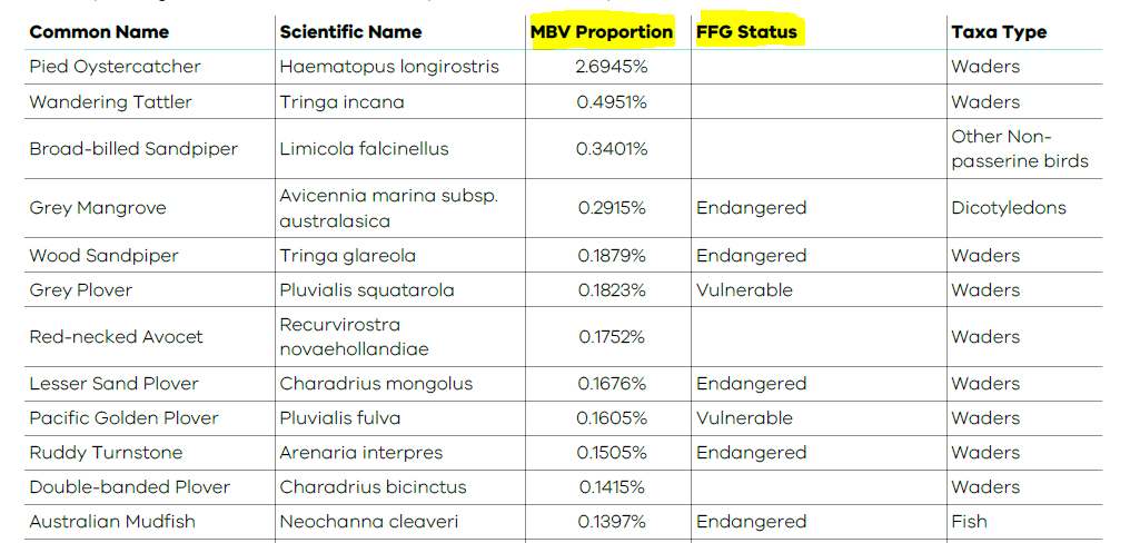
The MBV Species Assessment provides a tabled list of species that are likely to occur within the MBV Assessment Area. Of the 263 biodiversity features included in the MBV map, only 206 species are included in the MBV Species Assessment. The full list of MBV features that were assessed to create the MBV map should be considered.
The table provides key information for each species identified, including the common and scientific names, FFG Act threatened status, taxonomic classification, and the MBV Proportion. The MBV proportion represents the percentage of the species' statewide extent that overlaps with the MBV Assessment Area. Only species with a MBV Proportion greater than 0.001% are shown in the table. In general, if a proposal overlaps with 1% or more of a species known statewide distribution in Victoria, this may be considered significant and could trigger further investigation or referral under the Environmental Effects Act, particularly for species listed under the FFG Act or EPBC Act.
This analysis offers an indication of species that could be potentially impacted by the proposed activity, as well as an estimate of the scale of impact at a statewide level. The MBV Proportion and the FFG Status are particularly important data fields to consider when interpreting the information presented in the table.
While the MBV analysis provides a valuable first-pass screening assessment, it does not substitute for need for more detailed ecological assessments. It can be used to highlight areas and species that may warrant further investigation or targeted surveys, helping to inform early planning and environmental approvals. However, it does not conduct a full species risk assessment and users should be aware of several important limitations and caveats:
- The MBV only considers a sub-set of species, primarily those listed under the FFG Act and does not account for culturally significant species.
- The MBV map is static, reflecting data available at the time of publication. More recent data may be available.
- Species connectivity, migration routes and aerial habitat use are not represented, limiting the ability to assess ecological processes and risks.
- Resolution constraints (at 225m grid) which may limit site level precision.
- Areas of low biodiversity value may reflect data gaps rather than true ecological insignificance.
- The MBV map is a relative ranking spatial product and is not a regulatory "go/no-go" map.
Users are encouraged to consult complimentary tools such as the Victorian Biodiversity Atlas (VBA) accessed via NatureKit, and the Protected Matters Search Tool (PMST) for migratory species and EPBC Act listed threatened species. These resources can help validate the MBV outputs and support more robust, site-specific assessments.
Using Proximity analysis results
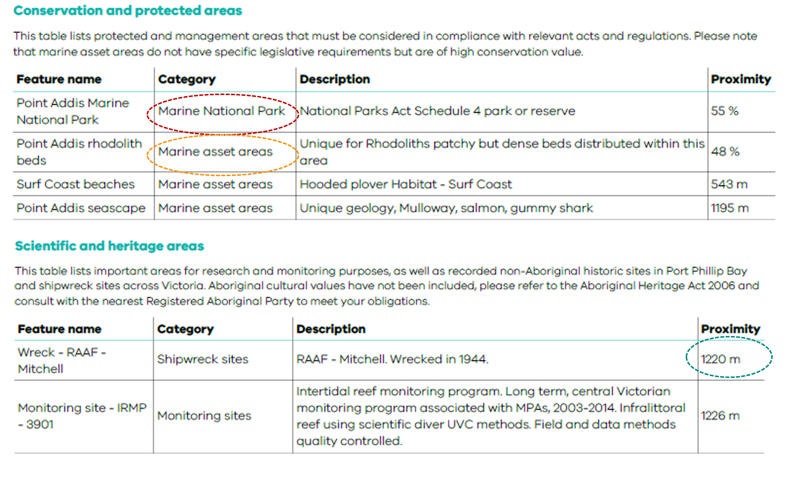
This can provide an indication of potential interactions with sensitive environmental assets, or other activities occurring in the vicinity from the project activities. The Proximity analysis is separate to the FeAST assessment and should be considered by user even if a low or no risk FeAST score has been attained.
The Proximity analysis can be used to identify ecological features and matters that may be subject to a more in-depth investigation or detailed environment assessment to avoid, minimise or reduce possible adverse effects.
Additionally, the Proximity analysis could be used to consider the impact of cumulative effects by identifying other existing marine and coastal activities near the project area. More information can be found in section 12.
4. Traditional Owners' rights, aspiration, and knowledge
It is critical in the early stages of any planning process to respect the rights, aspirations, and knowledge of Traditional Owners in Victoria. This includes acknowledging cultural and spiritual connections to land, biodiversity, and resources through a relationship with Country.
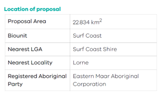
FeAST assists with identifying which Registered Aboriginal Parties (RAP) the project area overlaps with or is nearest to within 2km of the defined project area boundary. The first page of the FeAST report presents a table that lists the one or multiple RAPs as shown in the image below.
In cases when the report lists multiple RAPs, the defined project area either crosses both boundaries, or is equidistant from the RAPs (within a 2km buffer). Additionally, if the table shows a blank result this indicates that there is no RAP within 2km of the project area boundary.
Sites of cultural significance and value are not included in the FeAST assessment, it is the responsibility of the user to consult early with Traditional Owners about projects or matters that affect them, their country, and their communities. Some Traditional Owners have Country Plans, which should be considered as part of your application.
The Aboriginal Heritage Act 2006 and Aboriginal Heritage Regulations 2007 provide protection and management for Victoria's Aboriginal heritage with streamlined processes linked to the Victorian planning system.
If a proposed development is within an area of cultural heritage sensitivity, If a proposed development is within an area of cultural heritage sensitivity, the Aboriginal Heritage Planning Tool can help determine if it falls under the definition of 'high impact activity' and will need a Cultural Heritage Management Plan (CHMP). The First Peoples- State Relations Online Map (FPSR) can assist with this process.
5. Key legislation and policies
It is necessary to consider all relevant Victorian and Federal statutory mechanisms at an early stage of the decision-making process. The user is required to demonstrate the project’s accordance and consistency with relevant legislation, acts, regulation, plans, standards, policies, and frameworks.
Consulting these relevant mechanisms will assist with interpreting the FeAST report and determining next steps based on the significance of effects.
This section will advise users of the linkages between the FeAST assessment and legislative processes, and how FeAST can be used in these instances to provide useful information to inform these. The list of legislation and policies isn’t exhaustive, and users should conduct their own review.
Marine and Coastal Act 2018
FeAST aligns with several objectives of the Marine and Coastal Act 2018 (MACA), these principally include:
- Protect and enhance the marine and coastal environment.
- Promote the ecologically sustainable use and development of the marine and coastal environment and its resources in appropriate areas.
- Engage with specified Aboriginal parties, the community, user groups and industry in marine and coastal planning, management, and protection.
- Build scientific understanding of the marine and coastal environment.
FeAST has been developed in the context of the Marine and Coastal Policy. The Policy provides long-term policy guidance and adopts seven key principles for consideration in planning and decision making in the marine and coastal environment. The principles are shown in the below image:
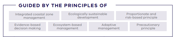
The Policy sets out how each of these guiding principles should be considered in the context of planning and decision making. The Policy also includes a Marine Spatial Planning Framework that provides guidance and a process for achieving integrated and coordinated planning and management of the marine environment.
FeAST provides key information for applications for MACA consent, and FeAST reports must be included when submitting applications for MACA consent.
Environment Effects Act 1978
The Environment Effects Act 1978 requires: a project with potential adverse environmental effects that, individually or in combination, could be significant in a regional or state context should be referred. The Ministerial Guidelines for Assessing Environmental Effects sets out the referral criteria for projects. In cases where the project has the potential for a significant environmental impact based on the marine environment related referral criteria, the outputs from FeAST should be included in the submission of the referral package for determining the need for an Environment Effects Statement (EES). The user should refer to the guidelines for precise formatting and content requirements, and information.
FeAST provides useful information on the existing environment, presenting analysis on some of the relevant environmental assets listed in the guidelines for inclusion. Not all the required environmental assets are captured by FeAST, this should be explored by the user. Full list of layers in the Proximity analysis can be found in the Supporting information page.
The FeAST outputs should also be used to identify potential adverse environmental effects and should meet the format and content requirements for EES referrals as set out by the guidelines. These include:
- Brief description of potential changes or risks to environmental assets resulting from the project.
- Available information on the likelihood and significance of such changes.
- The sources and accuracy of this information, and associated uncertainties.
Potentially significant effects should be described in sufficient detail for a reasonable conclusion to be drawn as to whether the project could pose a significant risk to those assets.
Flora and Fauna Guarantee Act 1988
FeAST supports the Flora and Fauna Guarantee Act 1988 (FFG Act), ensuring that decisions are made with proper consideration of the potential impact on biodiversity, aligning with the following objectives:
- to guarantee that all taxa of Victoria's flora and fauna, other than taxa specified in the Excluded List, can persist, and improve in the wild and retain their capacity to adapt to environmental change; and
- to prevent taxa and communities of flora and fauna from becoming threatened and to recover threatened taxa and communities so their conservation status improves; and
- to protect, conserve, restore and enhance biodiversity, including— (i) flora and fauna and their habitats; and (ii) genetic diversity; and (iii) ecological communities; and (iv) ecological processes; and
- to identify and mitigate the impacts of potentially threatening processes to address the important underlying causes of biodiversity decline; and
- to ensure the use of biodiversity as a natural resource is ecologically sustainable; and
- to identify and conserve areas of Victoria in respect of which critical habitat determinations are made.
A FeAST risk assessment provides information to reduce or avoid impacts to protected species and communities in the marine and coastal environment. The FeAST assessment does not replace the need for further work to identify if listed species may occur in the project area and considerations to ensure the project meets all obligations under the FFG Act.
Environment Protection and Biodiversity Conservation Act 1999
The commonwealth Environment Protection and Biodiversity Conservation Act 1999 (EPBC) provides a legal framework to protect and manage nationally and internationally important flora, fauna, ecological communities and heritage places, defined as matters of national environmental significance (MNES).
The FeAST assessment does not replace the need for further work to identify if MNES may occur in the project area and considerations to ensure the project meets all obligations under the EPBC Act. A FeAST risk assessment provides information to reduce or avoid impacts to MNES. Outputs from the FeAST report should be used in conjunction with results from the Protected Matters Search Tool.
Environment Protection Act 2017
The Environment Protection Regulations 2021 and the Environment Reference Standard (ERS) are subordinate legislative tools that support the Environment Protection Act 2017. The legislation enhances the protection of Victoria’s environment and human health through a more proportionate, risk-based environment protection framework that includes:
- A preventative approach through a general environmental duty.
- A tiered system of EPA permissions to support risk based and proportionate regulatory oversight.
- Significant reforms to contaminated land and waste management.
- Increased maximum penalties.
- Requirements for more environmental information to be publicly available.
- Modernising and strengthening EPA’s compliance and enforcement powers.
The Environmental Protection Agency (EPA) has produced a general guidance publication intended for businesses to assess and control risks, which follows four steps as shown in the diagram below.
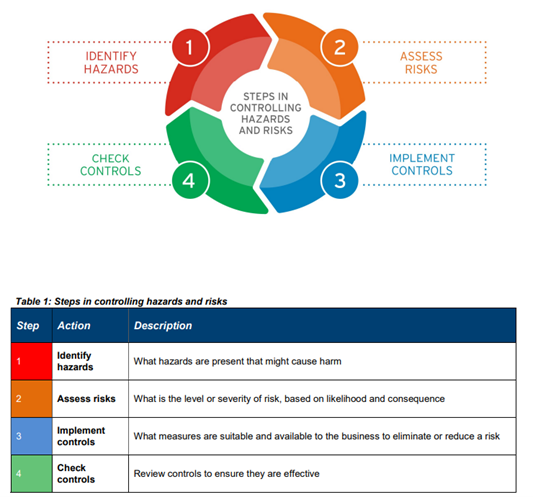
FeAST aligns with many of the principles listed under the principles of environment protection and is guided by duties relating to environment protection, principally the general environmental duty. The FeAST report supports identification of hazards, assessment of risk and identification of controls.
6. Supplementary information
Due to the current limitations and scope of FeAST, other decision-making tools should be used in conjunction with FeAST to supplement the information provided in the report. In particular, other government interactive mapping tools and other national tools to access the best-available information to provide to decision-makers.
All the information extracted from these tools (reports, spreadsheets, maps etc.) should be provided in addition to the FeAST report to the relevant decision maker to support an application.
NatureKit
Use the portal to query, extract and download a species list of threatened fauna and flora as listed on the FFG and EPBC acts on the Victorian Biodiversity Atlas (VBA) which details species sightings and observation records.
To understand the coastal vegetation in the vicinity of the defined project area explore Ecological Vegetation Classes (EVCs).
Native Vegetation Information Management system (NVIM)
The NVIM tool should be used if the proposal intends to remove, destroy, or lop any native vegetation. Removal of wetland vegetation (including saltmarsh and mangroves), and seagrasses may require a planning permit application under Clause 52.16 and Clause 52.17 of Victoria’s planning schemes.
Protected Matters Search Tool (PMST)
The PMST should be used to understand important EPBC act protected values. This includes information on migratory species, key ecological features, commonwealth marine areas, listed critical habitats and matters of national environmental significance for key consideration.
All the information extracted from these tools in the form of reports, spreadsheets, maps or other should be provided in addition to the FeAST report to the relevant decision maker to support an application.
7. Avoiding locations
It is the responsibility of the project proponent to seek options to avoid harm to habitats and ecological features as presented in the FeAST report. The FeAST score provides an indication of the risk to the habitats within the defined project area, and it is possible that the risks to habitats may be lower in an alternative location. If there is the option to relocate the proposal to another location, an options analysis can be undertaken using FeAST as detailed in the FeAST user guide.
In some cases, it will be a requirement to move the location of a proposed project due to the features identified in Proximity analysis tables. These may include, but are not limited to:
- Ramsar sites.
- Marine protected areas, marine sanctuaries.
- Protected shipwreck areas.
- Non-aboriginal cultural site.
- Important breeding, feeding or aggregation areas for listed species with a conservation or migratory status.
- Significant landscape or natural features.
- Existing infrastructure, activity conflict or emerging development area.
8. Undertaking field surveys
Irrespective of the FeAST assessment results, it may be important for the proponent to undertake their own field surveys and conduct a full impact assessment. The FeAST score and Proximity analysis can provide an indication of when and where field surveys may be useful to better understand the risk posed by the project.
FeAST is based on several limitations and assumptions as listed in Introduction to FeAST, the collection of new data would support better understanding of the level of risk and possible impacts of pressures.
Field surveys should be tailored to the local ecology and conditions and adopt a systematic and robust survey design for collecting data. It is recommended that survey design is informed by existing datasets, research, imagery, and studies. The habitat survey effort around Victoria is unevenly distributed and collecting information in data-deficient areas would inform the accuracy of classifying habitats, for more information see the Supporting information page.
For each field survey undertaken the proponent must ensure that the accompanying spatialised data is provided with the list below providing the minimum information to be included:
- Spatialised data in the form of mapped survey transects, study area or sampling points.
- Description of the methodology including rationale for the number of surveys.
- Description of the methods and equipment employed to undertake field surveys.
- Documented imagery (if appropriate) to be labelled with survey/sampling ID, aspect, field of view (degrees). Ensuring images are of high quality and resolution and are not blurry.
- Name and qualifications of surveyors.
- Date(s) of surveys or sampling.
- Objectives, findings, interpretations, and results from the field surveys (including the classification of the habitat type, recording flora and fauna present, environmental features, and condition of habitat).
- Weather conditions at the time of survey(s) and time of day.
- Reference to relevant guidance, technical manuals, OHS or best-practice documentation.
- Explanations of departures from guidance.
- Limitations associated with the survey design including seasonality and time of day.
9. Seasonal considerations
FeAST does not account for the seasonally important times of year for habitats and biodiversity or take into consideration seasonal changes in the distribution of other marine and coastal activities. The FeAST report can be used to guide and determine the most suitable time of year and day for specific activities to occur or the best times to avoid.
Look at the habitats in the FeAST assessment, the listed tables in the Proximity analysis and the pressures listed in the pressure score when considering the following:
- Biodiversity to minimise impacts and disturbance i.e. during important life-history events such as breeding, nursing, migrating, and nesting.
- Water quality to reduce the chance of poor water quality events i.e. postponing activities following significant rainfall or during months likely to see harmful algal bloom events.
- Impacts to people i.e. avoiding summer months and keeping works between social hours.
- Busy timings for other activities that could result in negative interactions i.e. seasonal shipping changes, fishing areas, anchorage areas.
10. Climate change and sea level rise
Proposed projects should be considered in the context of potential climate change impacts such as changing water temperature, sea level rise, changing coastlines, acidity and species distributions and movements.
The FeAST assessment is primarily focussed on understanding the risks of impacts to biodiversity, habitats, and ecosystems, and is not intended to assess risks posed by coastal hazards and processes.
The Victorian Resilient Coast program has developed a framework to support local government, land managers and communities with implementing place based, best practice and long-term coastal hazard risk management and adaption. CoastKit also provides shoreline and wave buoy data generated from the Victorian Coastal Monitoring Program.
11. Zone of influence
FeAST provides a semi-qualitative screening of risks and does not incorporate any modelled data as listed in the Introduction to FeAST.
Each activity and associated pressures will have a diverging scale of impact proportional to the size, duration, location in the water column, and magnitude of the effect. In addition to the FeAST report, a user may be required to undertake a full-footprint analysis and develop models for estimating the zone of influence or aerial range induced by pressures.
Any calculations should consider the local hydrodynamic and wave setting, and dynamic modelling may consist of estimating, but is not limited to:
- sediment dispersal plumes
- temperature and contaminant concentration changes
- underwater noise and vibration profiles
- light duration and intensity.
The level of risk and subsequent potential impact of activities on benthic habitats and environmental features can change depending on the time they are exposed to by a particular pressure and the varying strength of that pressure. FeAST does not account for changes in the duration or frequency of project activities, pressure events or does not consider changes in the concentration or power of a pressure.
The intensity of each pressure based on the activity has been expertly scored using a standardised list of benchmarks that assume a ‘normal scenario’ stressor profile. Any deviations away from these values will increase the risk factor of the pressure, this could affect the strength, concentration, or power of the pressure. This includes but is not limited to, changes in:
- the concentration of pollutants, chemicals, or surfactants
- the temperature discharges
- height of sedimentation
- depth of penetration or removal of sediment.
Additionally, it is important to consider the number of pressure events or the activity frequency. HELCOM (Berg et al. 2018) have developed a scale for estimating the pressure frequency, as shown in table below.
| Descriptor | Frequency |
|---|---|
| Persistent | More than three times per year or permanent. |
| Frequent | Two to three times per year. |
| Regular | Once per year. |
| Occasional | Less than once per year. |
The duration of time between which a pressure ceases and begins again should also be a key consideration. This may reduce the ability of the habitat to recover from an impact and have negative implications on specific environmental features. The Proximity analysis should be consulted in this instance.
| Could the project activities exceed the determined benchmarks for pressures as presented on the Supporting information page? Has this been accounted for? |
12. Cumulative effects
The FeAST assessment adopts a precautionary approach to take the most detrimental intensity level (high and medium) across each pressure to produce the Pressure score.
The intensity of each pressure is not combined or aggregated in any way across the selected activities, it merely takes the worst-case scenario to produce a first-pass screening of risks.
FeAST also does not consider the potential cumulative impact of other activities nearby to the defined project area. Multiple activities can have complex interactions and can potentially have greater impacts together than when considered separately.
The Proximity analysis can assist with this assessment of cumulative impact by identifying other marine and coastal activities occurring within a 2km buffer of the project area. It is important to note the Feature Atlas datasets are not exhaustive and may not include the most current information.
13. Developing mitigation measures
The FeAST report provides a starting point for developing a series a mitigation measures for the potential impacts and risks of activities.
All the identified pressures listed on the FeAST summary page of the report should be considered and may have mitigation measures developed. Consideration should be given to the likely success of measures and how they would function to reduce risk.
It is important for the proponent to consult best-practice guidelines for undertaking specific activities and developing mitigation measures to ensure that no further risks are posed. An environmental management plan and set of monitoring actions may be required to ensure mitigation measures are implemented effectively and the performance is reported on.
The robustness of measures should be evaluated to ensure that the mitigation proposed is not unachievable, experimental, unproven, or controversial, and to ensure adequate funding is available for the entire project.
14. Submitting the FeAST report
A copy of the downloaded FeAST report PDF and zipped FeAST score shapefile should be provided to the relevant decision-maker or approver. These outputs must be provided and presented in their original and unaltered state.
Please consult formal planning approval processes for full details on the how to submit and attach information in the MACA consent and the EES referral forms.
FeAST provides a PDF with a unique report name i.e. coastkit-feast-3d4ea93f-c743-4f6b-8dfb-44c4eb47000e.pdf and zipped file i.e. Export (22).zip.
In cases where multiple FeAST assessment have been generated, it is recommended that a systematic file naming structure is employed to ensure FeAST reports and shapefiles are stored and retrieved efficiently. For example, this could involve listing the project name, date and denoting a, b, c for each assessment:
- FeAST_report_projectname_date_a.pdf
- FeAST_score_projectname_date_b.zip
Page last updated: 02/09/25