Victoria’s marine environment is an active place and how we use it continues to grow and change.
Human uses of ocean space need to be organised and balanced to maintain a healthy marine ecosystem that supports multiple uses. The impacts of climate change and population growth must also be considered.
Marine spatial planning helps marine industry, government, and the community better plan activities in the marine environment, now and into the future. It can also support sustainable growth of Victoria’s blue economy and climate change adaptation planning.
Marine Spatial Planning Framework
The Marine and Coastal Policy 2020 includes a Marine Spatial Planning Framework (MSP Framework). The MSP Framework is required under the Marine and Coastal Act 2018.
The MSP Framework guides integrated planning and management of Victoria's marine environment. It also sets out Victoria’s approach to marine spatial planning.
The MSP Framework consists of 2 parts:
- Part A provides guidance and policies for marine planning and management decisions in Victoria, whether undertaking marine spatial planning or not.
- Part B outlines how to initiate, approve, and undertake marine spatial planning in Victoria.
Part B includes a 3-stage process for marine spatial planning:
- Stage 1: determine marine planning areas and identify areas that may benefit from marine spatial planning
- Stage 2: seek approval to undertake marine spatial planning using a mechanism in the Marine and Coastal Act 2018
- Stage 3: undertake marine spatial planning.
The MSP Framework identifies the Minister responsible for the Marine and Coastal Act 2018 as the lead minister for marine spatial planning.
The Department of Energy, Environment and Climate Action (DEECA) is therefore leading implementation of the MSP Framework, engaging with Traditional Owners, industry, marine users, and government agencies.
Victoria’s marine planning areas
The first stage in implementing Part B of the MSP Framework is to undertake a statewide ‘first-pass’.
The ‘first-pass’ divides Victoria’s marine environment into marine planning areas for future marine spatial planning processes. It also identifies areas that could benefit from marine spatial planning.
- Victoria's Marine Planning Areas (PDF, 9.1 MB)
- Victoria's Marine Planning Areas (accessible) (DOCX, 1.3 MB)
Marine Spatial Planning Guidelines
The Marine Spatial Planning Guidelines (MSP Guidelines) provide detailed instructions and guidance on how to undertake a marine spatial planning process in Victoria.
- Marine Spatial Planning Guidelines (PDF, 6.4 MB)
- Marine Spatial Planning Guidelines (accessible) (DOCX, 458.2 KB)
Strategic planning
Strategic planning, supported by tools such as MSP, is increasingly important to manage the growing pressures on our marine and coastal environments.
High-level syntheses of existing information on values and uses/activities within (or relevant to) the marine environments of Gippsland and the Southwest, have been developed.
These reports inform marine and coastal planning, environmental assessment, and regulatory approvals, and support evidence-based decision-making for emerging industries, including offshore wind development.
- Overview of values, uses and activities in Gippsland’s marine environment (PDF, 2.4 MB)
- Overview of values, uses and activities in Gippsland’s marine environment – accessible (DOCX, 3.4 MB)
- Overview of values, uses and activities in Victoria’s southwest marine environment (PDF, 1.2 MB)
- Overview of values, uses and activities in Victoria’s southwest marine environment – accessible (DOCX, 2.3 MB)
Case studies
To continue implementation of the MSP Framework, the following case studies have been compiled.
- Case Study #1 - Marine Plan Partnership (MaPP) in British Columbia, Canada (PDF, 200.5 KB)
- Case Study #1 - Marine Plan Partnership (MaPP) in British Columbia, Canada – accessible
(DOCX, 644.1 KB) - Case Study #2 - Marine Spatial Planning and Offshore Wind in Rhode Island, USA (PDF, 220.3 KB)
- Case Study #2 - Marine Spatial Planning and Offshore Wind in Rhode Island, USA – accessible (DOCX, 814.5 KB)
Undertaking marine spatial planning
Undertaking marine spatial planning is being explored through implementation of the Marine and Coastal Strategy 2022 and testing of the MSP Guidelines.
In addition, the MSP framework states that approval to undertake marine spatial planning in a marine planning area is required from the lead minister for marine spatial planning, in consultation with other relevant portfolio Ministers.
If you would like more information, please contact the Marine Spatial Planning Team: marine.spatial.planning@deeca.vic.gov.au
For more information on Marine Spatial Planning and the Marine Spatial Planning Framework.
For more information on how Marine Spatial Planning will be undertaken in Victoria.
Marine Spatial Planning
Q. What is marine spatial planning?
Marine spatial planning is a practical way to organise marine space, and the interactions among human uses and between uses and the marine environment.
It provides a process for assessing where activities and uses may be compatible or incompatible, and where activities and uses (either individually or cumulatively conflict. Undertaking a marine spatial planning process can have significant benefits including proactively identifying and reducing conflicts between uses, and between uses and natural values. This can help to help protect economic, social, cultural, and environmental values linked to the marine environment. It can also be used to support sustainable growth of Victoria’s blue economy and climate adaptation planning.
Q. When is marine spatial planning needed?
To date, most planning and management decisions in Victoria have focused on individual activities or uses (for example, fisheries, tourism, conservation), with responsibility shared between different government agencies and bodies. While this is still appropriate in some cases, marine spatial planning can have significant benefits where decision making is likely to be complex, challenging, or where managing individual activities and uses may be inadequate. As human uses and activities in the marine environment diversify and intensify, marine spatial planning can help to manage conflicts and identify compatibility of uses. This can be especially beneficial in environments with multiple conflicting uses, sensitive or significant habitats, or new and emerging industries.
Q. Who is responsible for marine spatial planning?
The Minister responsible for the Marine and Coastal Act 2018 is the lead minister for marine spatial planning in Victoria. The lead minister will seek approval from all ministers with interests in a marine planning area before authorising a marine spatial planning process, and before approving any resulting marine plan.
Marine Spatial Planning Framework
Q. What is the Marine Spatial Planning Framework?
The Marine Spatial Planning Framework is required under the Marine and Coastal Act 2018, and part of the Marine and Coastal Policy 2020. The framework provides overarching guidance and process for achieving integrated and coordinated planning and management of the marine environment. Application of the framework will support ecologically sustainable and equitable use and development. It will also help to support a healthy marine environment that provides environmental, social, cultural, and economic benefits.
Marine stakeholders helped to develop the framework through a co-learning and co-design process. Representatives across marine industries, peak bodies, government, non-government groups and marine research participated throughout the process, which included a period of public consultation on the draft MSP Framework.
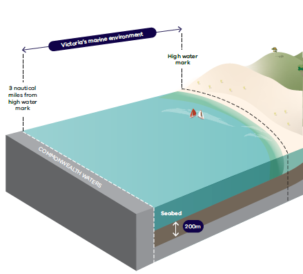
Q. Where does the Marine Spatial Planning Framework apply?
The MSP Framework applies to Victoria’s marine environment, which is defined in the Marine and Coastal Act 2018. It extends from the high-water mark out for 3 nautical miles, or 5.5 kilometres, to the boundary of Victoria’s state jurisdiction. This includes all bays, inlets, estuaries, and the Gippsland Lakes. The marine environment extends to a depth of 200 metres below the surface of the seabed, and includes all the animal, plants and other biodiversity associated with the land and water.
Given the dynamic and interconnected nature of marine and coastal environments, adjoining coastal land and marine waters are also considered when conducting a marine spatial planning process.
Q. Will marine spatial planning replace existing marine planning and management (for example, fishing, shipping)?
In Victoria, a range of existing legislation, policies and plans already provide direction for planning, management and decision making in the marine environment. This includes sectors such as marine transportation, energy generation, fisheries operations, and conservation. The MSP Framework does not replace, remove, or duplicate these existing arrangements or replace existing licensed or permitted rights.
Rather, it provides a structure for integrated management, and an approach to manage conflicts through existing legislation, policies and plans. As marine spatial planning is a participatory approach, stakeholders with existing use and access permits, licences or leases will be identified and engaged early in the process.
Q. What is the purpose of the MSP Guidelines?
The MSP Guidelines outline detailed instructions on how to undertake a marine spatial planning process in Victoria. Specifically, they:
- enable Traditional Owners to partner in marine planning and management
- guide the preparation, implementation, evaluation, and improvement of strategic plans for the marine environment
- support marine sectors, marine users, and the community to participate in marine planning and management.
The MSP Guidelines will be tested and refined when undertaking a first process.
Q. Where are Victoria’s marine planning areas?
Victoria’s marine environment has been divided into 8 marine planning areas, stretching across the entire length of the coast. The boundaries of the marine planning areas are indicative, with the inner and outer boundaries mapped according to the ‘marine environment’ definition in the Marine and Coastal Act 2018. Further refinement of the boundaries may be required as part of undertaking a MSP process.
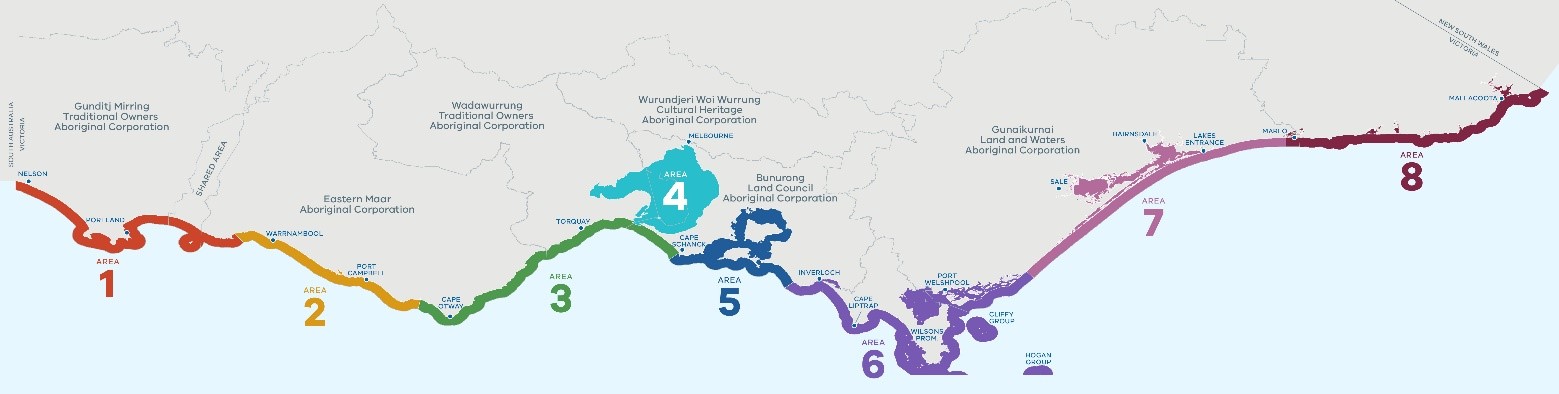
Q. Will a MSP process occur in every marine planning area?
Not all marine planning areas may require a MSP process, with some benefiting from other integrated planning and management approaches, such as ecosystem-based management. Where a MSP process does occur, the indicative boundaries and characteristics set out in the Victoria’s Marine Planning Area document provide baseline information to guide further investigations.
Q. How will marine spatial planning include Traditional Owners and Aboriginal communities?
Traditional Owners have an unbroken custodianship of the land and seas that extends back tens of thousands of years. Their knowledge, understanding, and relationships to Country are fundamental to the health of the environment and the success of any strategy to manage that environment. As such, the importance of Sea Country must be recognised and integrated into marine planning and management through a self-determined approach.
DEECA are partnering with Traditional Owners to implement the MSP Framework. In addition, when undertaking a marine spatial planning process, Traditional Owners must be supported to self-determine:
- their roles in marine spatial planning
- appropriate protocols and processes for Indigenous Data Sovereignty and how it is embedded in marine spatial planning
- how cultural landscapes and values, and Traditional Owner rights and objectives for Country, are reflected in marine spatial planning and resulting marine plans.
Q. When will marine spatial planning be undertaken?
Before a first marine spatial planning process can be undertaken, further investigations and agreement of the following are required:
- Who might lead a marine spatial planning process?
- What should the governance structure look like?
- What is the mechanism for undertaking marine spatial planning (for example, an Environmental Management Plan or a Regional and Strategic Partnership)? Should the mechanism be kept flexible or is a fixed approach preferable?
- How might a MSP process and the implementation of a resulting marine plan be funded?
Q. How can I get involved?
Victoria’s marine environment is used for a diversity of activities including fishing, boating, shipping, recreation, and tourism. Therefore, it is important that all these groups can input and shape how the marine environment is managed.
Marine spatial planning will involve a range of government and non-government groups that have an interest, connection, existing rights, or responsibilities related to a marine planning area.
For more information on opportunities to be involved, please visit Marine and Coasts or contact the Marine Spatial Planning team at marine.spatial.planning@delwp.vic.gov.au.
Page last updated: 19/03/26