Erosion is a natural process impacting many parts of Victoria’s 2,500 kilometres of coastline.
It is a challenge faced by coastal communities across Australia and the world.
Waves, wind, rain, and tides all impact the location and rate of erosion.
Coastal environments are also under pressure from
- climate change
- growing populations
- increased visitation
- historic planning issues.
What causes coastal erosion?
Coastal erosion is part of a natural cycle whereby sand is constantly building up or being eroded by waves, wind, rain and tides.
Storms can also cause erosion because they can generate increased wave and wind energy that impact the coastline, causing the rapid removal of sand.
Cliff collapses, also known as cliff failures, can occur when the internal strength of the cliff formation is reduced and it can no longer support its own weight.
This can occur when the cliff is exposed to:
- erosion at the cliff base
- changes in moisture content (drying or wetting)
- extreme heat and cold
- large rainfall events and erosive water runoff
- seismic activity.
Erosion and cliff failures are unpredictable and can occur without warning, posing a risk to clifftop and beach users. Land managers will take action when required to ensure public safety, including closing clifftops or beaches.
Managing coastal erosion
It is preferable to allow natural processes to occur without interference.
However, if erosion threatens community infrastructure, authorities may consider a range of management options.
Working together
To guide decision-making, land managers work together to develop and implement coastal adaptation plans.
These are plans that identify short and long-term options to manage the impacts and protect foreshores, Crown land and critical infrastructure from storm surges, wave attacks and rising sea levels.
Only management options that are technically feasible and that can potentially gain relevant approval under state and federal legislation are considered.
Our approach
Any intervention in coastal environments has pros and cons that can lead to impacts elsewhere, so land managers follow an adaptive or pathways approach to get the facts before committing to any one option.
Land managers use independent coastal and geotechnical engineers to assess natural processes impacting an area and identify all viable options.
These can range from nature-based methods like sand management or actions to protect a site such as groynes or sea walls.
This information gathering process can take time but is an important step to ensure land managers can make the right decision and implement the most appropriate option.
Where an emergency or fast response to an erosion event is required, land managers will consider immediate, short-term actions while the longer coastal adaptation plan process continues.
Community insights
Community engagement is an essential component of finalising the plans.
Local information provides valuable insights into how the community values and uses an area and how coastal environments have changed over time.
What is the ‘adaptive’ or ‘pathway’ approach?
All Coastal Adaptation Plans and proposed actions are prepared in line with the Marine and Coastal Policy 2020. The policy aims to reduce environmental impacts by adapting how we manage the coast, rather than relying on new or existing physical infrastructure where possible.
Authorities address and consider actions to manage coastal erosion in the following order, with physical structures like groynes or sea walls the last option.
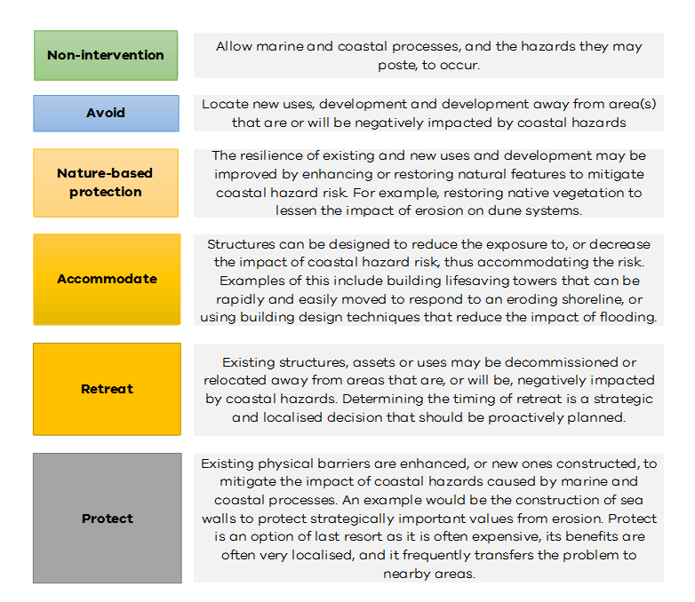
Potential management options
Applying the adaptive approach may result in a mix or multiple options being used over time.
Locate new uses, development, and redevelopment away from areas that are being or will likely be impacted by coastal erosion and hazards.
Many historic structures along Victoria’s coastline were built without appropriate consideration for coastal hazards and are on land now deemed inappropriate. For example, older structures built on sand dunes would not receive planning approval today.
Adapting to climate change and coastal erosion means making planning decisions that protect the environment and minimise intervention in the future.
Beach scraping is the process of re-shaping the beach profile. Machinery is used to move sand from the lower part of the beach to the upper part of the beach. This improves beach amenity and enables the beach to withstand the potential impacts of storm events better.
The advantage of beach scraping is that local sand sources can be used.
The main disadvantage is that it is temporary. Eventually the profile of the beach will change and further scraping may be required.
This is the process of reinstating dunes that have eroded. Dune building may require a combination of beach scraping and sand nourishment, and revegetation with native coastal species.
Dune vegetation cannot withstand severe erosion events. The vegetation does trap wind-blown sand, increasing the volume of the dune buffer, and thereby making it more resistant to future erosion events.
Nourishing a beach involves relocating sand from a marine sand bank, another beach or from a quarry.
Beach nourishment increases the volume of sand and builds resilience to erosion by increasing the buffer between the shoreline and infrastructure. The greater volume of sand deposited, the more resistant the beach is to coastal hazards such as erosion or inundation.
Sand nourishment increases the beach buffer. However, it can be expensive and is not always a long-term solution.
Groyne walls are placed perpendicular to the shoreline to trap sand as it washes past. They can reduce shoreline erosion on the up-drift side. However, sand is often eroded on the down-drift side.
Groyne material can be rock or geotextile bags.
Groynes tend to be visually intrusive in a natural beach environment.
Seawalls are placed parallel to the shoreline and are an effective means of protecting assets and infrastructure from erosion.
The main disadvantage of seawalls is that they are expensive and reflect wave energy that can lead to more beach erosion in front of the wall and lock up sand behind the wall that would otherwise be available for the natural processes of erosion and accretion on the beach.
Revetments are sloping structures built on embankments or shorelines, along the base of cliffs, or in front of seawalls to absorb and dissipate the energy of incoming waves to reduce coastal erosion.
Revetments are constructed from impact-resistant material such as timber, stone, concrete or sandbags.
Revetments absorb energy, unlike sea walls that reflect it. Therefore they are subject to greater erosion and ongoing maintenance is required. This increases the expense.
Artificial reefs are intended to replicate natural reefs in order to help protect beaches from the impact of storm waves. They do this by reducing wave energy before it reaches the shore.
Artificial reefs can also offer marine habitat and recreational opportunities such as surfing and snorkelling.
They can be an expensive option and if they aren’t designed well, can have a negative impact on natural coastal processes.
Projects
Learn more about coastal projects happening across Victoria.
Victorian Coastal Cliff Assessment
The Victorian Coastal Cliff Assessment project calculated coastal cliff instability and/or erosion and subsequent risk assessment for the coastal cliffs along the state of Victoria. The assessment was split into two stages:
- Stage 1: Assessment of Areas Susceptible to Coastal Cliff Instability and/or Erosion (ASCCIE)
- Stage 2: Coastal Cliff Risk Assessment
The study provided a state-wide/regional scale (also referred to as second-pass) assessment of Areas Susceptible to Coastal Cliff Instability and/or Erosion (ASCCIE) associated with areas at the cliff top and Areas Susceptible to Talus Runout (ASTaR) associated with areas at the bottom the cliff for the Victorian coastline.
The purpose of this second-pass assessment is to identify ASCCIE and ASTaR at a regional/state-wide scale for present-day and future timeframes. The resulting ASCCIE and ASTaR are then used to inform the second part of the assessment, the cliff instability risk assessment.
That assessment identifies assets at high risk to coastal cliff instability, erosion and slumping including consideration of public safety.
Read the final technical report here.
You can also view the data on CoastKit.
Gippsland
Read about the coastal projects in the Gippsland area.
Port Phillip
Find out about coastal projects in Port Phillip.
Barwon South West
Read about the coastal projects in the Barwon South West area.
Page last updated: 13/01/26