Glossary
Definition of the key terms used in the context of FeAST
This is a standardised list of human use, development or works that may be undertaken in the marine or coastal environment and associated with set pressure intensities.
The hierarchical classification unit under the Combine Biotope Classification Scheme (CBiCS). Biotopes at level 3 (habitat complex) are used in the FeAST assessment. This term is used interchangeably with habitat in this context.
Set biogeographical units used to divide regions into discrete areas, determined by distinct oceanographic, geomorphic and ecosystem processes, as well as biotope distributions.
Used to define the area where activities may occur in the defined marine and coastal area. Used in the context of risk to specifically consider biotic natural components of the defined marine and coastal area.
The assessment to produce a FeAST score is described as a first pass environmental risk assessment. It is specifically considering habitat, and involves screening of pressures, assessment of mapped habitats sensitivity to the screened pressures, and an assessment of exposure.
The extent and intensity of a pressure impacting a habitat within a biounit. Doesn’t include the planned duration of a lasting pressure.
The term used to describe the assets and values or activities in the marine environment that have been spatially represented in CoastKit. This includes species, communities, geology, landforms, protected areas, and existing infrastructure.
An area of benthic substratum that supports a site of recurrent species that are adapted to living in specific environmental conditions of that area. Habitats assessed in FeAST use the CBiCS classification for biotopes at level 3 (habitat complex).
The potential effect the pressure is likely to have on the ecosystem as induced by the activity. Standard intensity ratings for activities are used for pressure screening.
Is a term to describe the concept of a change, effect or influence an activity may have on a habitat. Used inter-changeably with effect.
This is how the activities may influence or affect habitats. In FeAST this is a standardised list of mechanisms with associated benchmarks and is considered in the context of impacts to habitats, although, the identified pressures can be considered in other contexts.
An approach with emphasis on caution and consideration of possible harm where conclusive evidence isn’t available. A precautionary approach is used to produce scores and was used to develop the foundational information used in FeAST.
The ability of a habitat to recover from disturbance or stress. Holling (1973).
Resistance characteristics indicate whether a habitat can absorb disturbance or stress without changing character. Holling (1973).
Risk is defined as the effect of uncertainty on objectives (ISO 31000 and DEECA risk management framework). In practice risk considers the likelihood of an event occurring, and the consequence or impact of that event.
For the FeAST score, risk is considered specifically as the possibility of irrecoverable impact to a habitat posed by a project’s activities.
The likelihood of change when a pressure is applied to a habitat. This is expressed the ability of the habitat to tolerate or resist change (resistance) and ability to recover from impact (resilience). Tillin et al. (2010), Tillin & Tyler-Walters (2014).
1. Purpose
FeAST has been developed to support better decision-making in the marine and coastal environment of Victoria. The purpose of FeAST is to allow users to undertake a desktop-based first pass risk assessment to evaluate environmental features that could be impacted by a proposed project.
FeAST is applicable for all proposed uses, works, or developments set to occur in the marine environment. The marine environment, as defined in the Marine and Coastal Act 2018, extends offshore from the high-water mark for three nautical miles (5.5km), the edge of the state’s jurisdiction. It includes all bays, inlets, estuaries, and the Gippsland Lakes. FeAST aligns with the mapped coastline of Victoria based on the zero-metre contour dataset derived from a digital elevation model.
FeAST is a first pass risk assessment and does not replace the need for more detailed assessment. FeAST should be undertaken in consideration of any local information and all relevant legislation, policy (including the Marine and Coastal Policy), and advice. Details on limitations are below in section 6 and more information on how to interpret and use the FeAST outputs can be found on the Using the FeAST report page.
FeAST integrates the spatial information available on CoastKit to assess the potential impact to habitats posed by the project. FeAST analyses the proposed activities and the project location and size, to provide a final FeAST score. The tool also conducts a Proximity analysis which lists key marine and coastal features likely to be impacted by the direct footprint of the project or within a 2km radius of the defined project area.
FeAST incorporates recent work mapping Victorian marine and coastal habitats using the Combined Biotope Classification Scheme (CBiCS).
CoastKit is a publicly available and interactive web-mapping portal to display marine and coastal information in Victoria. The portal is regularly updated and provides access to mapped data, resources, and tools to support evidence-based decision making.
The portal is organised by themes and hosts datasets on biodiversity, habitats, management zones, infrastructure, features of significance and Victorian Coastal Monitoring Program sites. FeAST is fully integrated in CoastKit and uses the information available to generate the assessments.
CoastKit has been created to assist with many different applications such as environmental impact assessments, coastal hazard assessments, marine spatial planning, reporting, research, and restoration needs.
CBiCS is a habitat classification system that provides a means of describing, mapping, and monitoring biological communities, abiotic structural habitat components and ecosystem types. At the core of CBICs is the concept of a biotope. The term biotope describes a community of species in a defined abiotic habitat.
FeAST is a structured tool for users to generate a rapid first-pass environmental risk assessment report. The assessment will inform processes including consents under the Marine and Coastal Act 2018 and referrals and scoping of Environment Effects Statements and other environmental assessments under the Environment Effects Act 1978. FeAST also supports the identification of further investigation needs, analysis of options, and development of mitigation measures to avoid, minimise or mitigate potential impacts.
2. Overview
FeAST provides a standardised assessment based on best-available information and is streamlined and cost-effective. The FeAST risk assessment outputs are the FeAST assessment report (presenting the FeAST score, Marine Biodiversity Values and Proximity analysis), and a FeAST score layer that provides a visual representation of risk across the defined project area.
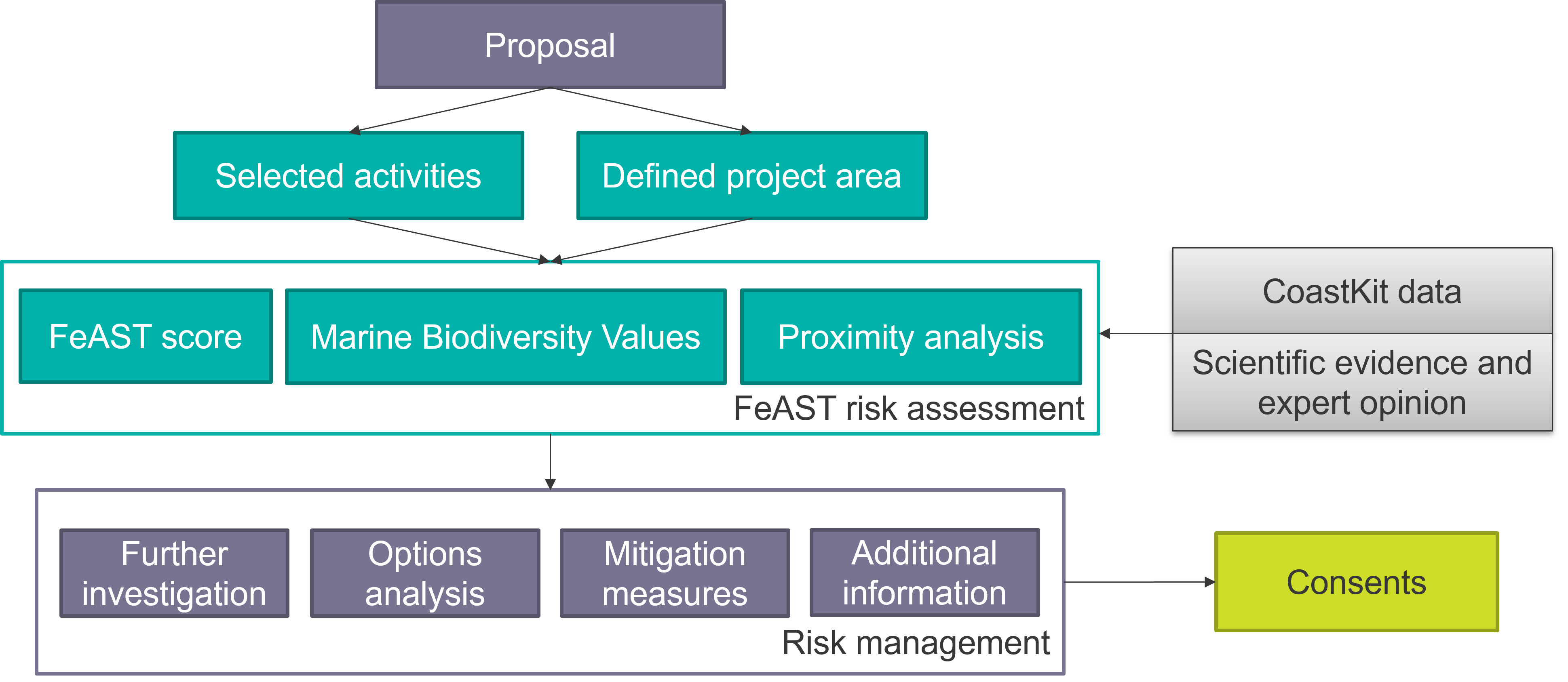 The FeAST score provides an assessment of risk to habitats, this:
- supports project planning to minimise environmental risks
- presents a standardised risk assessment to support decision making
- supports identification of further investigation needs based on the assessed risk level
- assists identification of where mitigation measures may need to be developed to avoid, minimise, and mitigate potential impacts.
The Marine Biodiversity Values analysis indicates how much of the proposal intersects with high biodiversity value areas and lists the associated species likely to occur.
- assists with site selection and planning to avoid areas of high biodiversity value
- highlights species that may be potentially impacted by the proposal type and location
The Proximity analysis generates a list of key environmental and social features extracted from CoastKit (excluding habitats) which are located either directly within the defined project area or within 2km of the defined project area, this:
- informs the need for further investigation or information by identifying key features
- assists identification of where mitigation measures may need to be developed to avoid, minimise, and mitigate potential impacts.
3. Context
FeAST has been developed for the State of Victoria and considers relevant state and national legislation, policies, and strategies. Development of the tool has been guided by research and expert opinion.
The tool, in conjunction with the Marine and Coastal Policy, supports the Marine and Coastal Act 2018 and Environment Effects Act 1978. FeAST supports area planning, pre-application planning, applications, options analysis, and assessing applications. FeAST collates the best-available marine and coastal environmental data and provides a transparent standardised process to ensure that all consent applications are uniformly assessed.
FeAST has been developed within the Marine and Coastal Knowledge Framework (MACKF). MACKF aims to promote improved data collection, management, and analysis to reduce uncertainty to better protect Victoria’s marine and coastal environments.
FeAST development has been led by scientific experts in partnering organisations responsible for compiling the foundational information in the FeAST data inventory. These partnering organisations also created a prototype original software application that FeAST has been modelled on.
The FeAST data inventory is a cloud-based relational database that stores all the data required for the operation of FeAST. This is part of a broader project to improve Victoria’s data holdings including classified data records, georeferenced literature and open-access imagery, video footage and other raw data. More information can be found in the Technical summary.
FeAST has been inspired by, and builds on, international applied research, tools, web-based applications, and frameworks. These include Marine Scotland’s Feature Activity Sensitivity Tool, The Marine Life Information Network’s Marine Evidence-based Sensitivity Assessment, Joint Nature Conservation Committee’s work on Marine Sensitivity Assessments, and the Integrated Biodiversity Assessment Tool.
4. Applications and users
FeAST has been developed to support:
- Planning permit applications under the Planning and Environment Act 1987 in the marine and coastal environment.
- Marine and Coastal Act 2018 consent applications to develop, use or conduct works on marine and coastal Crown land.
- Collating and interrogating spatial data during a marine spatial planning process.
- Scoping and preparation of Environment Effects Statements and other environmental assessments for project proposals as required by the Minister of Planning under the Environment Effects Act 1978.
- Considering impacts to Matters of National Environmental Significance, including migratory species, as required under the Environment Protection and Biodiversity Conservation Act 1999.
- Considering impacts to species and communities listed under the Flora and Fauna Guarantee Act 1988.
- Other approvals and project planning in the marine and coastal environment.
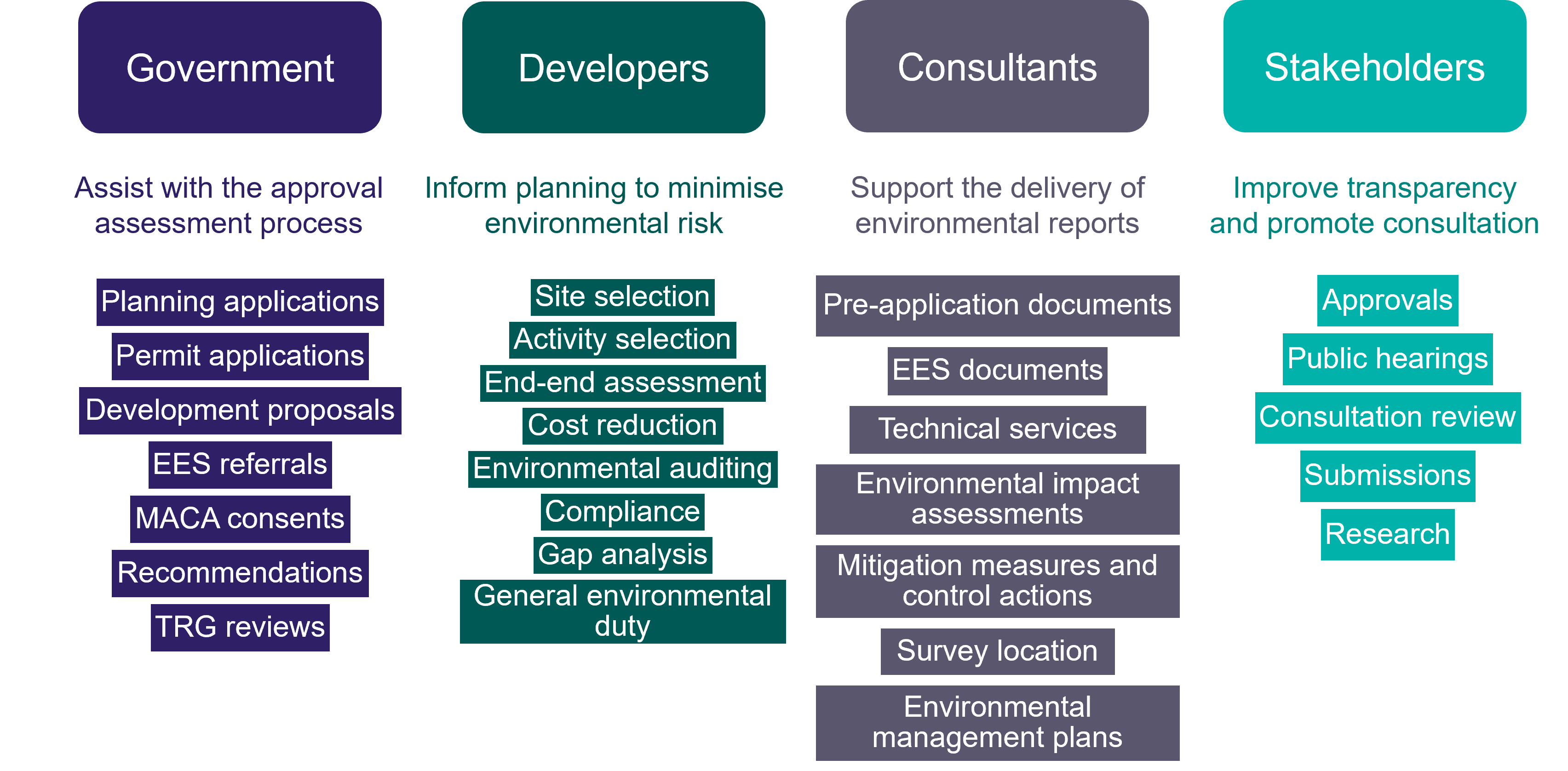
FeAST has been designed to support multiple stages of project planning and approvals as a first-pass environmental risk assessment tool. The above figure provides an overview of the FeAST users, and table below provides examples of how FeAST can be used to inform the various stages of the planning application process.
| Stage | User groups | FeAST application |
|---|---|---|
| Pre-application |
|
|
| Application submission |
| FeAST provides information for:
|
| Assessing application | Decision-makers, such as:
Interested stakeholders, such as:
|
In addition to supporting local, site and project specific assessments and planning, FeAST can also support strategic planning in the marine environment delivered through marine spatial planning. The Department of Energy, Environment and Climate Action is progressing implementation of Victoria’s Marine Spatial Planning Framework (part of the Marine and Coastal Policy 2020), and guidelines to support marine spatial planning have been developed.
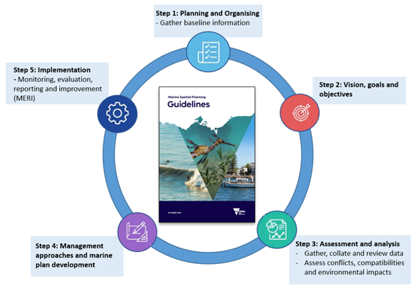
The Marine Spatial Planning Guidelines provide detailed step-by-step instructions, building on the direction in the Marine Spatial Planning Framework, on how to undertake a marine spatial planning process. As detailed in the guidelines, a key aspect of conducting a marine spatial planning process is utilising marine and coastal data and information using portals, such as CoastKit, and tools, such as FeAST (see figure). FeAST can support the steps in the marine spatial planning process by assisting in assessing and analysing the physical and biological characteristics in a marine planning area.
5. FeAST outputs
The FeAST assessment report provides the FeAST score, Marine Biodiversity Values analysis and Proximity analysis. The FeAST score illustrates the potential risk to habitats based on the sensitivity to disturbance, recovery potential and the activity footprint. The distribution of habitats assessed by FeAST have been modelled to the level of habitat complex (CBICs level 3) based on field survey records in the Biotope Atlas. The below table shows the CBICs hierarchy.
| Level | Category | Description | Example names |
|---|---|---|---|
| 1 | Environment | Major environmental type | Marine |
| 2 | Broad habitat | Environmental types segregated into habitat zones and substratum type | Sublittoral sediment |
| 3 | Habitat complex | Broad habitat factoring in energy regimes and grain size | Sublittoral seagrass beds |
| 4 | Biotope complex | Habitats grouped into similar physical and biological characteristics | Zostera - Ruppia |
| 5 | Biotope | Biotope complexes segregated by community composition and/or diagnostic species | Zostera nigricaulis |
| 6 | Sub-biotope | Defined by subtle differences in species assemblage, structure and geographical, temporal, or environmental variants. | Z. nigricaulis - dense |
The Marine Biodiversity Values analysis identifies whether the defined project area overlaps with areas of high biodiversity value and lists species likely to occur within the footprint. It uses data from the MBV map (2024), available on CoastKit, which ranks biodiversity across Victoria’s coastal waters.
The Proximity analysis acts as a search tool to provide an indication of the key marine and coastal features such as potentially sensitive ecological values and existing activities that may occur within the vicinity of the proposal.
The tool utilises spatial information from CoastKit’s Marine and Coastal Feature Atlas to produce a series of summarised tables organised into the following themes:
This table lists protected and management areas that must be considered in compliance with relevant acts and regulations. These include areas listed under the National Parks Act 1975 (marine national parks, marine sanctuaries, and marine and coastal parks), UNESCO Ramsar wetlands of national importance, declared shipwreck protection zones, animal protection areas and special management areas. Additionally marine asset areas are included but do not have specific legislative requirements but are of high conservation value.
This table lists geological sites and areas of high biodiversity including significant habitats, Flora and Fauna Guarantee Act 1988 listed marine communities and some important species sightings, and distributions (limited data available). It is recommended that NatureKit and the Protected Matters Search Tool should be used to extract the lists for threatened species observations, Environment Protection and Biodiversity Conservation Act 1999 protected values and migratory species.
This table lists designated areas for military and naval activity occurring on the coast and offshore. Specific activities may be prohibited, and relevant permits may be required.
The table lists existing areas for oil and gas infrastructure, saltworks and any sand extraction sites. Potential cumulative effects or interactions should be considered.
This table lists any aquaculture and fishery operations, reserves, and licenses with a commercial and recreational importance. Potential cumulative effects or interactions should be considered.
This table lists major shipping lanes, designated anchorage areas for vessels, dredging areas and marine disposal grounds. Potential cumulative effects or interactions should be considered.
This table lists sites of recreational value such as boating, diving, and sailing areas. Potential cumulative effects or interactions should be considered.
This table lists important areas for research and monitoring purposes, as well as recorded non-Aboriginal historic sites in Port Phillip Bay and shipwreck sites across Victoria. Aboriginal cultural values have not been included, please refer to the Aboriginal Heritage Act 2006 and consult with the nearest Registered Aboriginal Party to meet your obligations.
6. Limitations
FeAST has been designed to provide a rapid, cost-effective, and standardised assessment process that synthesises the best-available data to conduct a preliminary screening of risk. The outputs of the FeAST assessment are equivalent to undertaking a desktop-based study to identify likely concerns and issues of the project, which can be used to guide additional environmental assessments and filling of data gaps.
FeAST is a first pass risk assessment and does not replace the need for more detailed environmental or ecological assessment. The FeAST outputs should be interpreted with consideration of relevant legislation, policy, and advice. In particular, the Marine and Coastal Policy, developed under the Marine and Coastal Act 2018, provides statewide policy and direction to guide planning and decision making in the marine and coastal environment. For more information interpreting the results generated by the tool see page Using the FeAST report.
A semi-qualitative assessment method has been employed by FeAST to analyse risk. Experts have assigned numeric values to score specific components of interest across the state. This method provides a regional-scale perspective, where local characteristics or atypical behaviours of stressors may be overlooked. FeAST may not include all current and locally relevant information with regards to the activities undertaken, intensity of pressures, local habitat features and condition, current extent of habitats, or degree of habitat fragmentation.
FeAST only uses data available in CoastKit, currently this does not include information from other key data sources, tools, and portals. The user should use FeAST in conjunction with other state and Commonwealth tools. Such as:
- Flora and Fauna Guarantee Act 1988 (FFG) and Environment Protection and Biodiversity Conservation Act 1999 (EPBC) listed species records in the Victorian Biotope Atlas (VBA) accessed via NatureKit
- Ecological Vegetation Classes (EVCs) and Terrestrial Bioregions from NatureKit
- Matters of National and Environmental Significance (MNES), Migratory species and EPBC act species and communities from the Protected Matters Search Tool.
Separate assessments, permits and approvals of the impacts to FFG Act listed species and communities, EPBC Act listed matters and native vegetation impacts may be required. The Using the FeAST report page provides more information on how to consider what hasn’t been accounted for in FeAST.
There are several specific limitations that must be considered:
Assessed under normal conditions
The intensities used to determine the Pressure score are precautionary and represent ‘typical’ stressor profiles or scenarios according to experts. They do not consider the location, extent, seasonality, duration, or frequency that the pressure may be applied for. These details should be considered and investigated further by the user
Direct footprint analysis
The FeAST score only evaluates the risk to habitats within the direct footprint of the defined project area and does not conduct any form of environmental modelling. Activities and pressures have the potential to have zones of influence extending beyond the footprint, which may result in additional impacts not accounted for. The onus is on the user to select the most appropriate activities and define the full area likely to be impacted by the project with accuracy.
Environmental-based assessment
FeAST does not currently assess the safety, human health, societal, cultural heritage, technical or economic implications associated with the use, activity, or project development.
The FeAST assessment is primarily focussed on understanding the risks of impacts to biodiversity, habitats, and ecosystems, and is not intended to assess risks posed by coastal hazards and processes. The Victorian Resilient Coast program has developed a framework to support local government, land managers and communities with implementing place based, best practice and long-term coastal hazard risk management and adaption.
FeAST assessment extent
The tool does not assess habitats outside of Victorian State waters and the boundaries of the Victorian Marine Biogeographical Units (biounits) (Edmunds & Flynn, 2018). Coastal and inland freshwater habitats are currently not assessed. However, the Proximity analysis may identify coastal features within 2km of the project area.
Habitat classification scheme
FeAST adopts CBICs as the standard classification system for mapping habitats, which aligns with but will not be completely consistent with other classification schemes such as CATAMI (Collaborative and Annotation Tools for Analysis of Marine Imagery and video).
Project-specific assessment
The tool does not assess cumulative impacts or combined effects of multiple current, past, or emerging activities, uses or developments in an area. Additionally the tool does not consider the cumulative impact of the combination of activities of a single proposal.
Scale of decision-making
While FeAST and CoastKit are frequently updated with the data and available literature, the accuracy and confidence of information varies depending on the survey effort, quality of studies, and the dynamic nature of the marine and coastal environment. The scale of decision making is constrained by the accuracy of data available, and the resolution of the statewide habitat map.
Static assessment
FeAST currently uses a fixed baseline and does not account for variability such as temporal variation in species distributions and migration, hydrodynamics, weather patterns, climate change or intensity of activity pressures. In addition, the frequency, seasonal timings, and duration at which activities are planned or may occur has also not been accounted for in FeAST.
Page last updated: 22/09/25