Inverloch dune reconstruction and beach nourishment works
Visit the Cape to Cape Resilience Project webpage to find out more about what’s going on at Inverloch, Venus Bay, Anderson Inlet and other coastal areas between Cape Paterson to Cape Liptrap.
Jam Jerrup
- Location: Jam Jerrup
- Timing: Mangrove plantings completed in February 2022. Revetment and earth works completed in July 2021.
- Details: The Jam Jerrup coastline has been experiencing significant erosion that is impacting on native vegetation, public access and safety in the area.
DEECA, in partnership with the Bass Coast Shire Council, University of Melbourne and Lang Lang Foreshore Reserve Committee of Management, has developed an erosion management plan that focuses on a hybrid approach to combat erosion in the area.
Different methods of hard-structure coastal defence, including an extension of the existing rock revetment, have been combined with a trial planting of mangroves – a nature-based method led by the University of Melbourne.
A 150-metre rock revetment has been placed to extend the existing revetment and avoid further terminal scouring, alongside earthworks to cut and reshape the cliff face to make the site safer.
Over 150 mangroves have been planted in concrete planter clusters, which will be monitored and maintained by the University of Melbourne for the next 3 years.
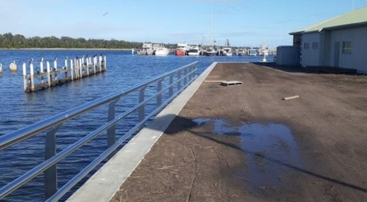
Lakes Entrance
- Location: Bullock Island Lakes Entrance, LEFL building
- Timing: Construction commenced July 2024 and was completed in February 2025.
- Details: The LEFL facility is located on the south-eastern side of Bullock Island and adjoins the LEFL buildings along the eastern edge.
Gippsland Ports managed the remediation of the LEFL seawall on DEECA’s behalf to address structural deterioration and scour at the base of the seawall. The efficient delivery of the works minimised impacts on the LEFL and port operations.
Construction of the seawall remediation works began in July 2024 and was completed in February 2025.
Lang Lang
Location: Lang Lang Foreshore Reserve
Timing: 2024
Details: Coastal adaptation pathways planning commenced in January 2024 with a consultant undertaking these works in consultation with DEECA and the Lang Lang Foreshore Reserve Committee of Management. Adaptation planning will allow DEECA and land managers in the area to better understand coastal risks and hazards and start developing adaptation options and plans for the foreshore reserve.
Lang Lang Foreshore Reserve Adaptation Planning Pathways Presentation Slide Pack
Lang Lang Forshore Caravan Park Frequently asked Questions December 2024
Watch the video below for the Lang Lang Foreshore Coastal Adaptation Plan presentation
View transcriptLoch Sport
- Location: Eastern half of the town adjacent to Lake Victoria.
- Timing: Report released in August 2022, Engagement Findings released in October 2022.
- Details: Following the release of the Loch Sport Coastal Processes and Options Assessment, DEECA sought feedback to help inform erosion management and adaptation measures for the Loch Sport Foreshore. We have reviewed all feedback and a summary of the survey findings is available Loch Sport Coastal Erosion Engagement Findings, October 2022.
Visit the Enage Victoria Loch Sport Foreshore Coastal Erosion page for more details.
- Location: Eastern half of the town adjacent to Lake Victoria.
- Timing: Project commenced in May 2023 and was finalised in June 2024.
- Details: DEECA engaged consulting firm BMT Commercial Australia Pty Ltd and FSC Range to commence action on the immediate steps recommended in the 2022 Loch Sport Foreshore Coastal Processes & Options Assessment.
This work involved:
- Detailed topographic survey and aerial photography to support the design of immediate actions
- Landslide Risk Assessment conducted on the 550 metre stretch along the high dune bluff area (identified in the 2022 report as Areas 4 and 5)
- Protection requirements and Options Assessment for Areas 4 and 5
- Concept designs for walking track relocation in highly impacted sites
- Options assessment for protection of the Seagull Drive boat ramp car park. Note that this area replaced "Area 7" in the original report due to Area 7 being Council freehold land, and the Seagull drive car park experiencing an exacerbation of erosion since the 2022 report
- Sediment sampling to inform borrow sites for renourishment works.
Finalised project deliverables:
High Dune Bluff area:
- Detailed lidar survey and aerial photography
- Landslide risk assessment
- Detailed designs and drawings of the walking trail pathway realignment
- Victorian Common Funding Agreement with Loch Sport Foreshore Committee of Management for reinstatement of walking trail
- High dune bluff protection options assessment
- Sediment sampling to inform potential sand sources
- Coastal Acid Sulfate Soil (CASS) testing
- Detailed design drawings and technical specification for beach nourishment work proposed at the base of the High Dune Bluff
- Detailed design drawings and technical specification for a staged installation of a groyne field proposed for the base of the High Dune Bluff.
Seagull Drive area:
- Boat ramp and carpark protection options assessment
- Geotechnical investigations
- Marine ecology survey
- Victorian Common Funding Agreement with Gippsland Ports for the beneficial reuse of sand at Seagull Drive
- Detailed design drawings and technical specification for a small groyne field proposed for Seagull drive boat ramp car park.
Mallacoota
- Location: Betka River mouth, south of Mallacoota
- Timing: Completed June 2022.
- Details: The 70-metre Betka Beach timber seawall was damaged in the 2019-2020 bushfires. DEECA replaced the seawall with a horizontal concrete seawall of the same dimensions and with design improvements to meet fire safety specifications and boost its resilience to extreme weather events. The passive recreational vessel access ramp and staircase have also been replaced with fireproof structures.
Ninety Mile Beach
- Location: a 25-kilometre strip of land located between Bass Strait and Lake Reeve that extends north of the Honeysuckles to Paradise Beach.
- Timing: Acquisition of high-priority lots commenced early 2024.
- Details: DEECA is working with partners to achieve a long-term solution for affected lots at Ninety Mile Beach.
- Visit the Ninety Mile Beach Acquisition Program webpage for more information about this project.
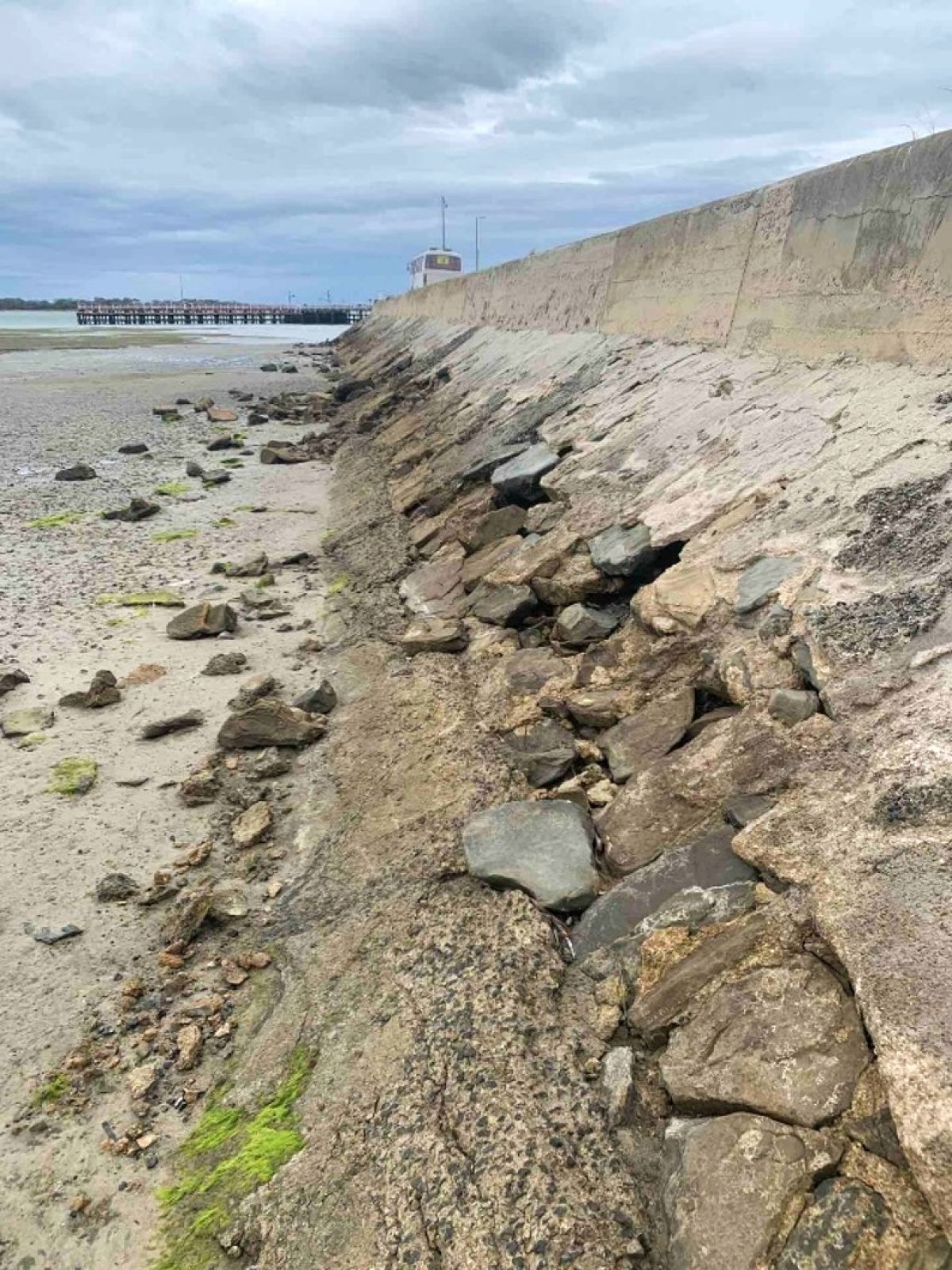
Port Welshpool
- Location: Port Welshpool Ferry Terminal
- Timing: Construction completed in December 2023.
- Details: The Port Welshpool seawall, which protects a road and provides access to a commercial wharf and ferry services, has been replaced
The design for the new seawall involved a full rock revetment remediation to reduce impacts on coastal processes due to higher energy absorption capability and less wave reflection.
Construction of the seawall remediation works began in August 2023 and were completed in December 2023.
Aligned with the original masonry seawall, the new seawall is approximately 114 metres long and has a design life of 50+ years. It ensures the continued use of the jetty for both recreational and commercial use. Additionally, the new design provides a more diverse habitat compared to the previous masonry seawall.
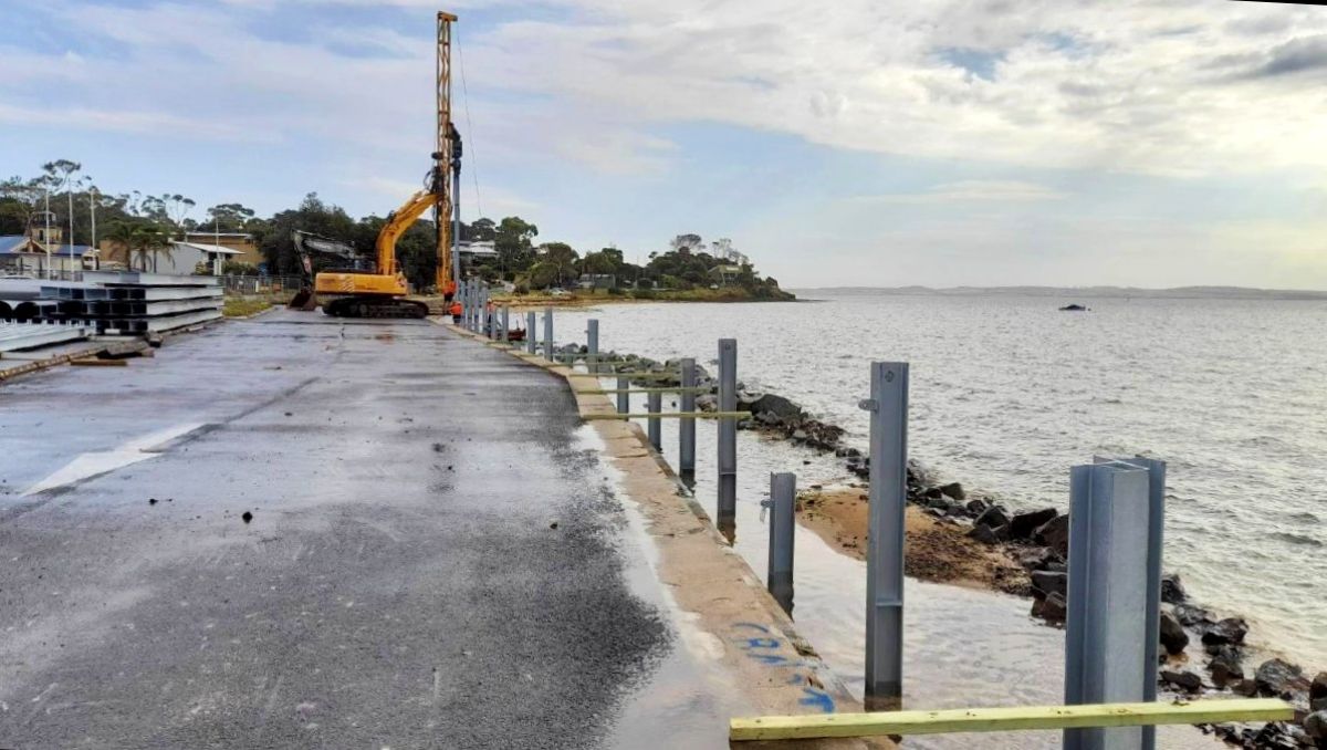
Rhyll
- Location: Rhyll boat ramp, Phillip Island
- Timing: Stage 1 completed September 2022, stage 2 completed October 2024.
- Details: Bass Coast Shire Council, with support from DEECA, completed Stage 1 of a new concrete panel seawall to replace an existing 85 metres of seawall at Denne Bight, Rhyll. This project was part of the redevelopment of the Rhyll Boat Ramp Facility that Bass Coast Shire delivered in partnership with Better Boating Victoria (BBV).
Stage 2 works began in August and were completed by October 2024. The replacement of the north side seawall is an extension of the completed seawall replacement works completed by Bass Coast Shire Council in 2022. The project involved replacing 45 metres of the existing seawall, along with upgrades to the footpath, kerb and viewing platform. These improvements reduce the risk of seawall failure and enhance pedestrian access and safety.
Silverleaves
We have been working with Bass Coast Shire Council in response to community concerns about coastal erosion at Silverleaves. We have implemented short-term sand renourishment works and a rock bag revetment to protect the dune from further erosion.
In 2025 consultants FSC Range completed the East Cowes and Silverleaves adaptation plan. The plan outlines a list of potentially viable adaptation pathway options for managing coastal hazards along the Silverleaves foreshore for the coming decades.
In line with the adaption plan, we have engaged FSC Range to develop designs for the recommended adaptation option pathway which responds to the current conditions. The pathway includes a nature-based hybrid approach involving a rock sill supporting the establishment of native shoreline plants, targeted dune nourishment and dune reconstruction and repair and realignment of the eastern end of the existing rock revetment. FSC will also investigate existing ecological conditions, undertake an environmental impact assessment, flora and fauna survey, and environmental risk and management plan.
Further updates will be provided to our stakeholder email and this website as we progress through the investigation and design stage.
Information on the adaptation planning can be found at Planning for coastal adaptation pathways at Silverleaves | Engage Victoria
Information about the Silverleaves coastal processes study can be found below:
- the community values and experiences survey in 2024
- the East Cowes and Silverleaves Adaptation Pathways Planning survey in May 2025
- the Silverleaves Community Reference Group
- other engagement activities
With an understanding of the coastal processes at Silverleaves and feedback via community surveys and engagement activities, FSC Range have completed the East Cowes and Silverleaves adaptation plan.
The plan outlines a list of potentially viable adaptation pathway options for managing coastal hazards along the Silverleaves foreshore for the coming decades. A pathways approach is used to help determine what combinations of adaptation actions might be feasible where and when.
Community input has informed the final adaptation plan and has been sought via:
Next steps
DEECA have now engaged FSC Range to develop designs for the recommended adaptation option pathway which responds to the current conditions.
Over the past 3 years, we have been working with Bass Coast Shire Council in response to community concerns about coastal erosion at Silverleaves. We have implemented short-term sand renourishment works and a rock bag revetment to protect the dune from further erosion.
In 2025 consultants FSC Range completed the East Cowes and Silverleaves Adaptation Plan. The plan outlines a list of potentially viable adaptation pathway options for managing coastal hazards along the Silverleaves foreshore for the coming decades.
In line with the adaptation plan, we have engaged FSC Range to develop designs for the recommended adaptation option pathway which responds to the current conditions. The pathway includes a nature-based hybrid approach involving a rock sill supporting the establishment of native shoreline plants, targeted dune nourishment and dune reconstruction and repair and realignment of the eastern end of the existing rock revetment.
FSC will also investigate existing ecological conditions, undertake an environmental impact assessment, flora and fauna survey, and environmental risk and management plan.
Further updates will be provided to our stakeholder email and this website as we progress through the investigation and design stage.
Information on the adaptation planning can be found at Planning for coastal adaptation pathways at Silverleaves | Engage Victoria
Watch the video below for an in-depth presentation about the Silverleaves coastal processes study put together by FSC Range.
View transcriptCoastal erosion and other related pages
Image gallery

Page last updated: 23/05/26