Marine and Coastal Knowledge Framework
To make better decisions about how to manage our marine and coastal environments, we need knowledge on how they operate and respond to changes.
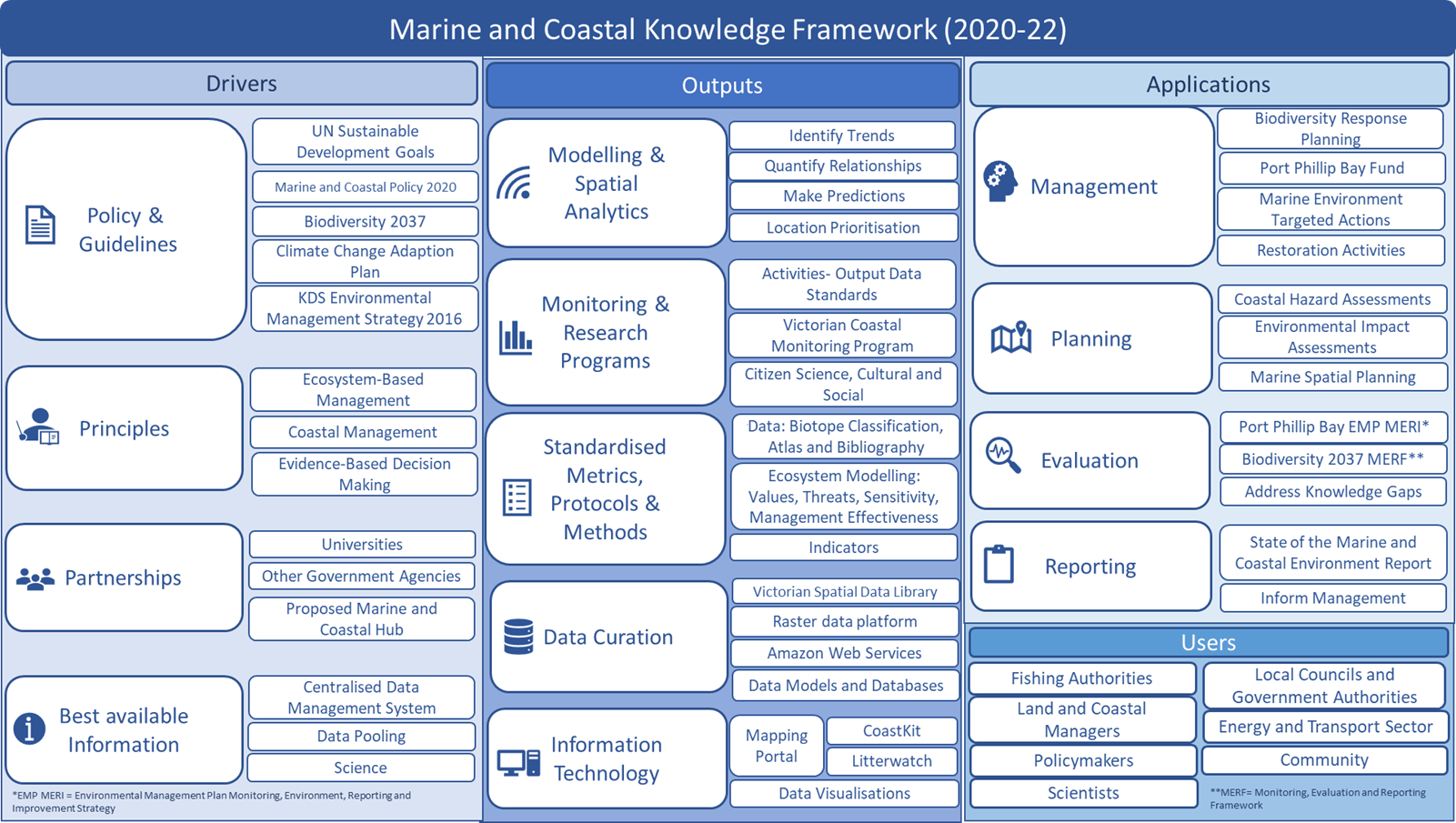
The Marine and Coastal Knowledge Framework (MACKF) includes standards for data collection, management, and analysis to inform decision making.
Read the Marine & Coastal Knowledge Framework Strategic Directions 2020-22 (PDF, 4.6 MB).
Read the Marine & Coastal Knowledge Framework Strategic Directions 2020-22 (DOCX, 16.1 MB).
The MACKF has 3 core themes:
- Drivers: the legal and policy setting which is guided by international scientific and management principles.
- Outputs: the Knowledge Management System which pulls on scientific and socioeconomic data from research programs and data modelling.
- Applications: the components that apply the data and information products to support management and planning decisions and their evaluation.

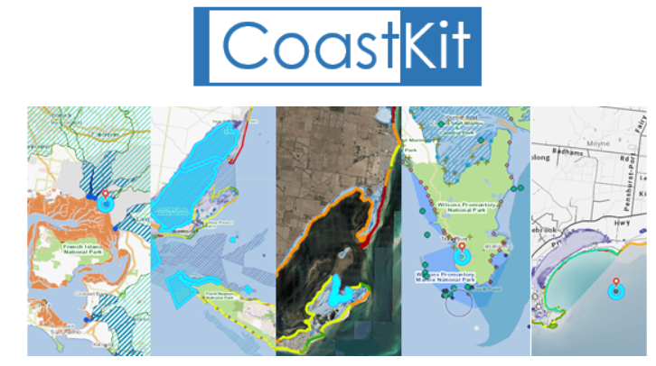
The framework has been designed to connect with CoastKit.
Current policy drivers and priorities
This framework captures current policies and plans including:
Marine and Coastal Policy 2020 and Environmental Assessments
The Marine and Coastal Policy 2020 is designed to deliver a healthy, dynamic and biodiverse marine and coastal environment that is valued in its own right, and that benefits the Victorian community, now and in the future.
The policy includes a Marine Spatial Planning (MSP) Framework that provides a process for achieving integrated and coordinated planning and management of the marine environment. Implementation of the MSP Framework will include a State-wide Assessment to determine marine planning areas and priorities, and development of MSP Guidelines.
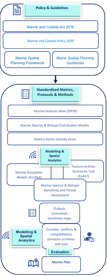
The outputs and application components of MACKF can be used to assist in implementation of the MSP Framework, in particular undertaking MSP processes.
The diagram on the right illustrates how output and application components of the MACKF are developed and linked to the policy and MSP Framework.
The MACKF also assists in undertaking environmental assessments through the application of modelling and spatial analytics. Data on marine species, habitats and features along with sector activities and their areas of operational and socio-economic importance, can be used as inputs. A suite of ecosystem models will then quantify the interaction of sector activities, such as fisheries, tourism, renewable energy and extraction, with marine species and features present in the area of interest. The models are informed by sensitivity assessments to existing and proposed activities evaluated by cumulative risk assessments against all sector activities. The approach will provide spatially explicit outputs, enabling those undertaking environmental assessments to consider objectives and environmental values to manage various uses and evaluate trade-offs.

Outputs
The outputs theme of the Marine and Coastal Knowledge Framework is supported by the CoastKit knowledge management system that provides managers and researchers with access to marine biodiversity and environmental data through knowledge portals.
CoastKit includes marine and coastal data from historic and contemporary monitoring and research programs. This includes observational records, models and map information products.
Key outputs:
- Combined Biotope Classification Scheme (CBiCS) (PDF, 5.5 MB) a new marine ecological classification scheme to meet new challenges.
- Statewide Habitat Map created from available habitat observations recorded in Victoria’s waters, combined with predictive modelling and mapping techniques.
- Features Atlas that describes priority marine features, management areas and sites of significant ecosystem or cultural services.
- Geo-bibliography of projects and studies that can be searched spatially or with key words.
Outputs under development
- Features Activity Sensitivity Tool (FeAST) that provides sensitivity ratings for marine habitats and priority marine features to pressures and activities using the Marine Evidence based Sensitivity Assessment process developed by Tyler-Walters et al 2020 at the Marine Life Information Network.
- Ecological Network Modelling Tool (EcoNet) to construct ecosystem models that represent the relationships between marine species, habitat and/or features and their ecosystem or cultural services. The models link drivers, activities and pressures in an integrated network. A review of the approach is provided by Elliot et al 2017.
Applications
A key application of the Framework is to provide communities with access to Victoria’s marine and coastal data using online mapping, visualisation technology and ArcGIS StoryMaps.
This includes:
- CoastKit: to access marine and coastal data and maps.
- CoastKit StoryMaps:
Priorities for 2022-23
The priorities and next steps for the Marine and Coastal Knowledge Framework and CoastKit are:
- Aligning with Biodiversity 2037’s NatureKit products and tools. We will develop datasets, indicators and models that represent marine biodiversity, marine condition, ecological process and threats that occur in the marine environment.
- Providing data and decision support for the Marine Spatial Planning Framework.
- Developing ArcGIS StoryMap's, report cards and visualisations of environmental and activity datasets for the Port Phillip Bay Environmental Management Plan 2017-2027 and 5 yearly evaluation report due in mid 2024.
- Developing StoryMaps, report cards and visualisations for the Victorian Coastal Monitoring Program and coastal hazard management projects.
- Supporting various monitoring, evaluation, reporting and improvement projects such as State of the Environment Reporting and various environmental assessment projects.
Page last updated: 18/04/24
