Introduction
Victoria's marine and coastal biogeographical settings provide a foundational framework for the description, mapping, and monitoring of its biological communities, abiotic structural habitat components, and ecosystem types, applicable across a range of spatial scales. Applications include marine spatial planning, environmental assessments, and the development of conservation strategies. These settings also support sustainable resource management and inform policy decisions to protect and preserve marine biodiversity.
The precise boundaries for these biogeographical settings and spatial units were established in 2024, integrating contemporary data from the Combined Biotope Classification Scheme (CBiCS) catalogue alongside other referenced sources. Most source data are available on CoastKit, and AusSeabed. High resolution LIDAR imagery, and aerial photography was derived from Vicmap Imagery. Multibeam SONAR bathymetric data was derived from the Victorian Coastal Digital Elevation Model 2022 (VCDEM2022). Data on sub-catchment boundary mapping was provided by Victoria’s Catchment Management Authorities.

Hierarchical Structure and Classification
The State's coastal and marine shelf environments are situated within the broader Temperate Australasian Realm, forming part of the Southeastern Australian Shelf Province. Within this Province, Victoria's marine biogeography is systematically delineated into a nested hierarchy of spatial mapping units, including ecoregions, biounits, segments, and habitat zones.
The spatial hierarchical structure comprises six levels of resolution:
The Victorian coastal and shelf environments are within the Temperate Australasian Realm. This realm includes the southern coasts of the Australian continent, from Western Australia, Southern Australia, Tasmania, New South Wales and New Zealand. This realm is typified by kelp and seaweed beds infralittoral zone rocky reefs and non-coral reef building sessile invertebrates in the circalittoral zone.
Victoria’s marine environment is part of Southeastern Australian Shelf Province. This province encompasses the southern-most coasts of Australia and has three primary influences:
- Maugean influence- cool temperate conditions and species of Tasmania and Bass Strait
- Peronian influence - warm temperate influences of eastern Australia and the East Australia Current
- Flindersian influence - warm temperate influences of southern Australia and eastward currents across the Great Australian Bight
This is a large area with distinct biotas that have cohesion over evolutionary time frames. The Victorian province holds a level of endemism, principally at the level of species.
Although historical isolation has played a role, many of these distinct biotas have arisen as a result of distinctive abiotic features that circumscribe their boundaries. The Province exhibits several large geomorphological features (isolated island and shelf systems, semi-enclosed seas); hydrographic features (currents, upwellings); and geochemical influences (broadest-scale elements of nutrient supply and salinity).

Victoria has three marine ecoregions within the Southeastern Australian Shelf Province:
- West Bassian
- Bassian
- Cape Howe
These three marine ecoregions reflected the various Maugean, Flindersian and Peronian influences, differences in aspect and exposure to oceanic systems and the Bass Strait shelf that connects central Victoria to Tasmania.
The species composition and biotopes of each ecoregion has been determined by the predominance of a distinct suite of oceanographic or topographic features. The dominant biogeographic forcing agents defining the ecoregions vary from location to location but may include isolation, upwelling, nutrient inputs, freshwater influx, temperature regimes, exposure, sediments, currents, and bathymetric or coastal complexity.

The three ecoregions in Victoria are divided into 29 biounits.
These are large scale biophysical domains, with a nominal scale of 10s to 100s kilometres, with a dominance of a particular type of seascape, or complex of seascapes and a predominant energy regime. Examples include large enclosed embayments, linear coast sections and large headland complexes.
Biounits are delineated by distinct seascapes and clusters of biotopes, reflecting the environmental conditions, and often have distinctive or unique biotopes within them. The species comprising characteristic biotopes may be more widespread. Whilst biounits are delineated by seascapes and biotopes, the mapping is also separated by State jurisdiction borders and subdivide ecoregions out to the edge of the continental shelf to 200m depth zone. Biounits represent the Marine Planning Areas of Victoria’s Marine Spatial Planning Framework.

Biogeographic segments are subdivisions of biounits that are at a nominal scale of 1-10s kilometres. Segments are characterised by spatially contained sets of habitats and biotopes. They include recognisable and distinguished seascapes, physiographic units, geoform complexes, depth profile and by different energy regimes, including tidal streams, wind fetch and wave exposure.
Segments generally contain whole ecosystem domains, such as the extent of reef patches, vegetation stands, particular types of biogenic structures, forms of primary productivity, close ecological associations and ecological sequences. Some smaller segments are mainly defined by energy regime and do not necessarily encompass complete systems but rather contain unique elements that distinguish them from elsewhere.

Habitat zones are components of segments and contain one or more CBiCS Level 3 Habitat Complexes. The scale of habitat zones varies but are nominally at 10s to 1000s of metres. Habitat zones can be readily delineated from remote sensing, aerial imagery, bathymetry data and prior mapping. The habitat zones group habitats with similar ecological properties, such as littoral sediment vegetation, seagrass banks or reef systems.
Habitat zones include anthropogenic areas, such as urban, rural and agricultural areas, which are used for masking in analyses and computational routines.
Habitat zones include management area boundaries where those boundaries indicate habitat modifications, such as dredged channels, spoil grounds, anchorages, moorings and aquaculture areas.

Do the new settings replace earlier versions?
Yes, the 2024 marine and coastal biogeographical settings enhance the previous 2018 version, which mapped only at the biounit scale up to 5.5 km offshore. The new mapping units extend offshore to encompass adjoining shelf waters and inland to correspond with their contiguous coastal catchment boundaries.
These new settings also supersede the earlier Integrated Marine and Coastal Regionalisation of Australia (aka “IMCRA”) regions developed for Victoria. Historically, IMCRA guided national-scale bioregional mapping in the 1990s but has not been updated since 2006.
The biounit boundaries to 5.5 km offshore still align to Victoria’s Marine Planning Areas which a marine plan and its identified management actions will apply through a Marine Spatial Planning Framework. The interactions and connectivity across the land, sea and catchment interface are essential to consider when undertaking a marine spatial planning process.
Marine and Coastal Values Assessment of Victoria's Biounits
This section presents biounit-scale profiles that describe the marine and coastal values occurring within each biounit, aligned to the inland extent of the Marine and Coastal Act Crownland (200m).
Each biounit profile provides a spatially explicit summary of the ecological and management values, including:
- Physical setting, describing the dominant coastal and marine geomorphology and exposure
- Traditional Owners, identifying the Registered Aboriginal Parties associated with each biounit
- Management areas, limited to IUCN Category II (National Parks) and Category III (Natural Monuments/Features)
- Marine Key Ecological Features (KEFs), including the number, name and tier
- Habitat complexes, identifying dominant marine and coastal habitats (areas > 1 km²)
- Biodiversity values, including species, ecological processes, and key habitats
- Activities and pressures, existing or emerging influences affecting the biounit
Each profile also includes a biounit map, which shows:
- The spatial extent of the biounit boundaries and labelled segments
- Marine parks and reserves
- The location and tiering of Marine KEFs*
The information presented in this section draws on spatial layers and derived products available through CoastKit, in combination with the following key data sources:
- Marine biogeographical settings and ecosystem domains in Victoria (Edmunds M., 2024),
- Assessment of the values of Victoria's marine environment: Atlas (VEAC, 2019),
- Victorian Marine Biogeographical settings (Edmunds, M., Flynn, A., 2018).
* Due to map layer stacking order some Marine KEFs may be partially or fully obscured. For the most current and complete KEF information, refer to the Marine Key Ecological Features webpage.
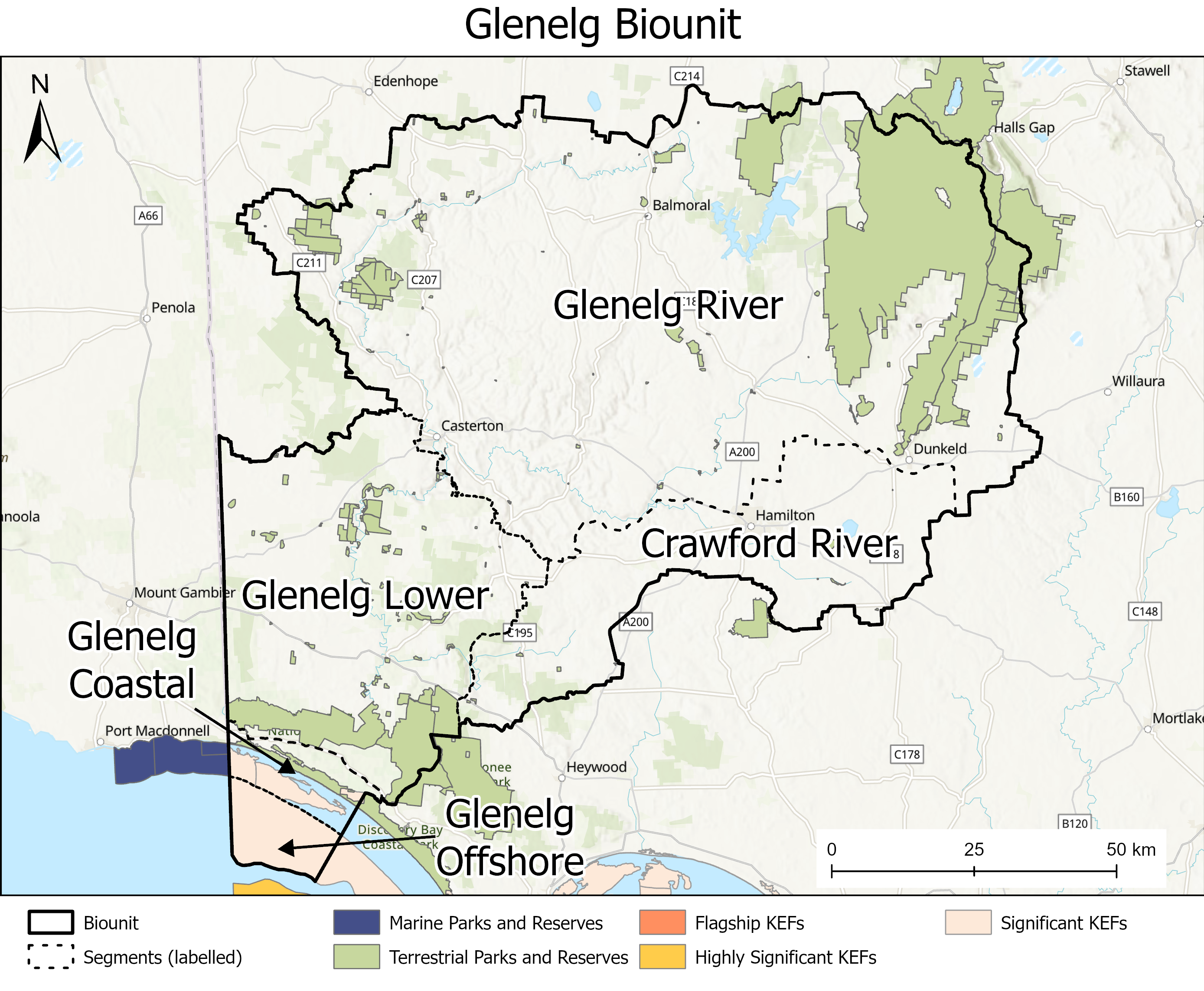
Physical Setting: The Glenelg biounit spans from the South Australian border into Discovery Bay, including the Glenelg River estuary. It features wave-dominated surf beaches, sublittoral reefs and sediments, estuarine wetlands, saltmarsh, and coastal vegetation. Influenced by Bonney Upwelling and strong tidal streams.
- Total Area: 12425km2
- Ecoregion: Western Bassian
- Segments: 5
Traditional Owners:
- Gunditj Mirring Traditional Owners Aboriginal Corporation
Management Areas:
- Discovery Bay Coastal Park
- Glenelg Estuary and Discovery Bay Ramsar Site
Marine Key Ecological Features: 5 (Significant: 5; Highly Significant: 0; Flagship: 0):
| Significant (5) | Highly Significant (0) | Flagship (0) |
|---|---|---|
|
| Habitat Complexes | Biodiversity Values | Activities and Pressures |
|---|---|---|
|
|
|
Physical setting: Eastern Discovery Bay and Cape Bridgewater; extremely exposed coastline with wave-dominated surf beaches, rocky shores, cliffs, coastal dunes, and lagoons. Includes sublittoral and inner shelf reefs, influenced by Bonney Upwelling and strong tidal streams.
Total area: 1531 km²
Ecoregion: Western Bassian
Segments: 7
Traditional Owners:
- Gunditj Mirring Traditional Owners Aboriginal Corporation
Management Areas:
- Discovery Bay Marine National Park
- Discovery Bay Coastal Park
- Glenelg Estuary and Discovery Bay Ramsar
Marine Key Ecological Features: 8 (Significant: 6; Highly Significant: 1; Flagship: 1):
Significant (6) | Highly Significant (1) | Flagship (1) |
|---|---|---|
|
|
|

Habitat Complexes | Biodiversity Values | Activities and Pressures |
|---|---|---|
|
|
|
Physical setting: From Bridgewater Bay to east of Port Fairy, this biounit includes capes, promontories, islands, exposed beaches, rocky shores, coastal cliffs, lagoons, and estuaries. Features volcanic structures, sublittoral and deep low-profile reefs. Portland Bay is more sheltered.
Total area: 7621 km²
Ecoregion: Western Bassian
Segments: 15
Traditional Owners:
- Eastern Maar Aboriginal Corporation
- Gunditj Mirring Traditional Owners Aboriginal Corporation
Management Areas:
- Cape Nelson State Park
- Discovery Bay Coastal Park
Marine Key Ecological Features: 20 (Significant: 18; Highly Significant: 2; Flagship: 0):
Significant (18) | Highly Significant (2) | Flagship (0) |
|---|---|---|
|
|

Habitat Complexes | Biodiversity Values | Activities and Pressures |
|---|---|---|
|
|
|
Physical setting: From east of Port Fairy to west of Cape Otway, this cliffed coast features stacks, islands, small bays, wave-dominated beaches, and rocky shores. Includes sublittoral reefs, sandy sediment plains, lagoons, and river estuaries. Extremely exposed with strong surge.
Total area: 22644 km²
Ecoregion: Western Bassian
Segments: 19
Traditional Owners:
- Eastern Maar Aboriginal Corporation
Management Areas:
- Merri Marine Sanctuary
- The Arches Marine Sanctuary
- Twelve Apostles Marine National Park
- Bay of Islands Coastal Park
- Great Otway National Park
- Port Campbell National Park
- Western District Lakes Ramsar Site
Marine Key Ecological Features: 24 (Significant: 23; Highly Significant: 1; Flagship: 0):
Significant (23) | Highly Significant (1) | Flagship (0) |
|---|---|---|
|
|

Habitat Complexes | Biodiversity Values | Activities and Pressures |
|---|---|---|
|
|
|
Physical setting: Rocky cape from Cape Otway to Apollo Bay with exposed headlands, beaches, coastal lagoons, and the Aire River estuary. Features sublittoral and offshore shelf reefs, strong tidal currents at the tip, and high geoform complexity. Exposure ranges from extreme west to high east.
Total area: 3157 km²
Ecoregion: Western Bassian
Segments: 10
Traditional Owners:
- Eastern Maar Aboriginal Corporation
Management Areas:
- Marengo Reefs Marine Sanctuary
- Apollo Marine Park (Commonwealth)
- Great Otway National Park
Marine Key Ecological Features: 14 (Significant: 12; Highly Significant: 1; Flagship: 1):
Significant (12) | Highly Significant (1) | Flagship (1) |
|---|---|---|
|
|
|

Habitat Complexes | Biodiversity Values | Activities and Pressures |
|---|---|---|
|
|
|
Physical setting: Northern Bass Strait offshore muddy sediment plain to Tasmanian border; very flat seabed to ~80 m depth.
Total area: 11232 km²
Ecoregion: Bassian
Segments: 1
Traditional Owners:
- Eastern Maar Aboriginal Corporation
Marine Key Ecological Features: 1 (Significant: 1; Highly Significant: 0; Flagship: 0):
Significant (1) | Highly Significant (0) | Flagship (0) |
|---|---|---|
|
|

Habitat Complexes | Biodiversity Values | Activities and Pressures |
|---|---|---|
|
|
|
Physical setting: Linear coast from north of Apollo Bay to south of Barwon Heads, with wave-dominated beaches, rocky headlands, sublittoral reefs, rhodolith beds, and small estuaries. Sheltered from westerlies but exposed to refracted swells; strong ground surge.
Total area: 1757 km²
Ecoregion:
Segments: 6
Traditional Owners:
- Eastern Maar Aboriginal Corporation
Management Areas:
- Eagle Rock Marine Sanctuary
- Point Addis Marine National Park
- Point Danger Marine Sanctuary
- Great Otway National Park
Key Ecological Features: 20 (Significant: 20; Highly Significant: 0; Flagship: 0):
Significant (20) | Highly Significant (0) | Flagship (0) |
|---|---|---|
|
|

Habitat Complexes | Biodiversity Values | Activities and Pressures |
|---|---|---|
|
|
|
Physical setting: Large sheltered embayment and sediment basin with low energy conditions. Features shallow reefs, sandy/muddy beds, seagrass meadows, drift algal beds, Pyura reefs, and saltmarshes. High productivity from microphytobenthos and seagrass; includes Geelong Arm and Corio Bay.
Total area: 11569 km²
Ecoregion: Bassian
Segments: 17
Traditional Owners:
- Bunurong Land Council Aboriginal Corporation
- Wadawurrung Traditional Owners Aboriginal Corporation
- Wurundjeri Woi Wurrung Cultural Heritage Aboriginal Corporation
Management Areas:
- Jawbone Marine Sanctuary
- Point Cooke Marine Sanctuary
- Ricketts Point Marine Sanctuary
- Point Cooke Marine Sanctuary
- Ricketts Point Marine Sanctuary
- Edithvale-Seaford Wetlands Ramsar Site
- Port Phillip Bay (Western Shoreline) and Bellarine Peninsula Ramsar Site
Marine Key Ecological Features: 49 (Significant: 49; Highly Significant: 0; Flagship: 0):
Significant (49) | Highly Significant (0) | Flagship (0) |
|---|---|---|
|
|

Habitat Complexes | Biodiversity Values | Activities and Pressures |
|---|---|---|
|
|
|
Physical setting: Tide-swept entrance with deep canyon (to ~100 m), flood-tide delta, Swan Bay, and Mud Islands. Features rocky coasts, headlands, tide-swept reefs and sediments, deep channels, seagrass beds, and delta banks. Strong currents dominate this high-energy zone.
Total area: 434 km²
Ecoregion: Bassian
Segments: 6
Traditional Owners:
- Bunurong Land Council Aboriginal Corporation
- Wadawurrung Traditional Owners Aboriginal Corporation
Management Areas:
- Port Phillip Heads Marine National Park
- Mornington Peninsula National Park
- Point Nepean National Park
- Port Phillip Bay (Western Shoreline) and Bellarine Peninsula Ramsar Site
Marine Key Ecological Features: 20 (Significant: 17; Highly Significant: 2; Flagship: 1):
Significant (17) | Highly Significant (2) | Flagship (1) |
|---|---|---|
|
|
|

Habitat Complexes | Biodiversity Values | Activities and Pressures |
|---|---|---|
|
|
|
Physical setting: Outer coast from south of Barwon Heads to west of Cape Schanck, partially sheltered but exposed to refracted westerly and easterly swells. Features wave-dominated beaches, rocky headlands, extensive intertidal platforms, sublittoral reefs, and Barwon estuary.
Total area: 5108 km²
Ecoregion: Bassian
Segments: 5
Traditional Owners:
- Bunurong Land Council Aboriginal Corporation
- Eastern Maar Aboriginal Corporation
- Wadawurrung Traditional Owners Aboriginal Corporation
Management Areas:
- Barwon Bluff Marine Sanctuary
- Great Otway National Park
- Mornington Peninsula National Park
- Point Nepean National Park
- Port Phillip Heads Marine National Park
- Port Phillip Bay (Western Shoreline) and Bellarine Peninsula Ramsar Site
Marine Key Ecological Features: 9 (Significant: 9; Highly Significant: 0; Flagship: 0):
Significant (9) | Highly Significant (0) | Flagship (0) |
|---|---|---|
|
|

Habitat Complexes | Biodiversity Values | Activities and Pressures |
|---|---|---|
|
|
|
Physical setting: Southern coast from Cape Schanck to Cape Woolamai and Western Port’s western entrance. Very high wave exposure with basalt and granite headlands, pinnacles, high-energy beaches, and complex sublittoral reefs and sediments.
Total area: 664 km²
Ecoregion: Bassian
Segments: 8
Traditional Owners:
- Bunurong Land Council Aboriginal Corporation
Management Areas:
- Mushroom Reef Marine Sanctuary
- Mornington Peninsula National Park
- Mushroom Reef Marine Sanctuary
- Phillip Island Nature Park
Marine Key Ecological Features: 11 (Significant: 11; Highly Significant: 0; Flagship: 0):
Significant (11) | Highly Significant (0) | Flagship (0) |
|---|---|---|
|
|

Habitat Complexes | Biodiversity Values | Activities and Pressures |
|---|---|---|
|
|
|
Physical setting: Moderate to low-energy embayment with strong tidal streams, dendritic channels, and extensive littoral banks. Features mangroves, saltmarsh, seagrass beds, infralittoral/circalittoral reefs, bryozoan reefs, and high turbidity in places.
Total area: 3878 km²
Ecoregion: Bassian
Segments: 6
Traditional Owners:
- Bunurong Land Council Aboriginal Corporation
- Gunaikurnai Land and Waters Aboriginal Corporation
- Wurundjeri Woi Wurrung Cultural Heritage Aboriginal Corporation
Management Areas:
- Churchill Island Marine National Park
- French Island Marine National Park
- Yaringa Marine National Park
- French Island National Park
- Mornington Peninsula National Park
- Phillip Island Nature Park
- Western Port Ramsar Site
Marine Key Ecological Features: 50 (Significant: 47; Highly Significant: 1; Flagship: 2):
Significant (47) | Highly Significant (1) | Flagship (2) |
|---|---|---|
|
|
|

Habitat Complexes | Biodiversity Values | Activities and Pressures |
|---|---|---|
|
|
|
Physical setting: Linear coast between Eastern Entrance and Bunurong, directly exposed to surf waves. Features wave-dominated beaches, sublittoral reefs, and sediments, with reefs influenced by turbid outflows from Western Port.
Total area: 838 km²
Ecoregion: Bassian
Segments: 5
Traditional Owners:
- Bunurong Land Council Aboriginal Corporation
Management Areas:
- Bunurong Marine Park
- Yallock-Bulluk Marine and Coastal Park
Marine Key Ecological Features: 3 (Significant: 3; Highly Significant: 0; Flagship: 0):
Significant (3) | Highly Significant (0) | Flagship (0) |
|---|---|---|
|
|

Habitat Complexes | Biodiversity Values | Activities and Pressures |
|---|---|---|
|
|
|
Physical setting: Coast from Harmers Haven through Cape Paterson to Venus Bay and north of The Arches at Cape Liptrap. Cliffed shoreline with wave-dominated beaches, rocky headlands, rhodolith beds, coastal lagoons, and Anderson Inlet. Strong long-period ground surge.
Total area: 2442 km²
Ecoregion: Bassian
Segments: 7
Traditional Owners:
- Bunurong Land Council Aboriginal Corporation
- Gunaikurnai Land and Waters Aboriginal Corporation
Management Areas:
- Bunurong Marine National Park
- Cape Liptrap Coastal Park
- Yallock-Bulluk Marine and Coastal Park
Marine Key Ecological Features: 6 (Significant: 6; Highly Significant: 0; Flagship: 0):
Significant (6) | Highly Significant (0) | Flagship (0) |
|---|---|---|
|
|

Habitat Complexes | Biodiversity Values | Activities and Pressures |
|---|---|---|
|
|
|
Physical setting: Southern Venus Bay (The Arches) around Cape Liptrap to SE Waratah Bay. Basaltic headland with wave-dominated beaches, rocky headlands, and sublittoral reefs and sediments. Waratah Bay is moderately sheltered.
Total area: 630 km²
Ecoregion: Bassian
Segments: 4
Traditional Owners:
- Bunurong Land Council Aboriginal Corporation
Management Areas:
- Cape Liptrap Coastal Park
Marine Key Ecological Features: 7 (Significant: 7; Highly Significant: 0; Flagship: 0):
Significant (7) | Highly Significant (0) | Flagship (0) |
|---|---|---|
|
|

Habitat Complexes | Biodiversity Values | Activities and Pressures |
|---|---|---|
|
|
|
Physical setting: Western Wilsons Promontory from southern Waratah Bay to Southeast Point. High water clarity, very high exposure on the SW coast and islands. Features high- to moderate-energy shores, complex circalittoral reefs, extensive low-profile reefs, sediment beds, and coastal inlets.
Total area: 846 km²
Ecoregion: Cape Howe
Segments: 8
Management Areas:
- Corner Inlet Marine and Coastal Park
- Shallow Inlet Marine and Coastal Park
- Wilsons Promontory Marine National Park
- Wilsons Promontory Marine Park
- Wilsons Promontory Marine Reserve
- Cape Liptrap Coastal Park
- Wilsons Promontory National Park
- Corner Inlet Ramsar Site
Marine Key Ecological Features: 9 (Significant: 6; Highly Significant: 2; Flagship: 1):
Significant (6) | Highly Significant (2) | Flagship (1) |
|---|---|---|
|
|
|

Habitat Complexes | Biodiversity Values | Activities and Pressures |
|---|---|---|
|
|
|
Physical setting: Eastern Wilsons Promontory from Southeast Point to east of Nooramunga, influenced by Corner Inlet outflows with lower water clarity. Features high- to moderate-energy coasts, circalittoral reefs, wave-dominated beaches, and extensive muddy sediments.
Total area: 780 km²
Ecoregion: Cape Howe
Segments: 7
Traditional Owners:
- Gunaikurnai Land and Waters Aboriginal Corporation
Management Areas:
- Beagle Australian Marine Park
- Nooramunga Marine & Coastal Park
- Wilsons Promontory Marine National Park
- Wilsons Promontory Marine Park
- Wilsons Promontory Marine Reserve
- Wilsons Promontory National Park
- Corner Inlet Ramsar Site
Marine Key Ecological Features: 12 (Significant: 10; Highly Significant: 1; Flagship: 1):
Significant (10) | Highly Significant (1) | Flagship (1) |
|---|---|---|
|
|
|

Habitat Complexes | Biodiversity Values | Activities and Pressures |
|---|---|---|
|
|
|
Physical setting: Sheltered embayment with dendritic channels, shallow banks, and granite islands, including Singapore Deep. Features sand flats, seagrass beds (Posidonia, Zostera), mangroves, saltmarsh, circalittoral rock, and biogenic reefs in channels.
Total area: 979 km²
Ecoregion: Cape Howe
Segments: 16
Traditional Owners:
- Gunaikurnai Land and Waters Aboriginal Corporation
Management Areas:
- Corner Inlet Marine and Coastal Park
- Nooramunga Marine & Coastal Park
- Wilsons Promontory Marine Park
- Corner Inlet Marine National Park
- Wilsons Promontory Marine Park
- Wilsons Promontory National Park
- Corner Inlet Ramsar Site
Marine Key Ecological Features: 9 (Significant: 7; Highly Significant: 1; Flagship: 1):
Significant (7) | Highly Significant (1) | Flagship (1) |
|---|---|---|
|
|
|

Habitat Complexes | Biodiversity Values | Activities and Pressures |
|---|---|---|
|
|
|
Physical setting: Barrier-island inlet system including Port Albert, with channels and sandy islands. Features sand flats, banks, seagrass beds, mangroves, and saltmarsh.
Total area: 1412 km²
Ecoregion: Cape Howe
Segments: 6
Traditional Owners:
- Gunaikurnai Land and Waters Aboriginal Corporation
Management Areas:
- Nooramunga Marine and Coastal Park
- Corner Inlet Ramsar Site
Marine Key Ecological Features: 4 (Significant: 3; Highly Significant: 0; Flagship: 1):
Significant (3) | Highly Significant (0) | Flagship (1) |
|---|---|---|
|
|
|

Habitat Complexes | Biodiversity Values | Activities and Pressures |
|---|---|---|
|
|
|
Physical setting: Isolated group of rocky islands east of Wilsons Promontory with limited biological data. Features rocky islands and surrounding reefs.
Total area: 1212 km²
Ecoregion: Cape Howe
Segments: 2
Marine Key Ecological Features: 4 (Significant: 4; Highly Significant: 0; Flagship: 0):
Significant (4) | Highly Significant (0) | Flagship (0) |
|---|---|---|
|
|

Habitat Complexes | Biodiversity Values | Activities and Pressures |
|---|---|---|
|
|
|
Physical setting: Victorian portion of the Hogan Group islands on the outer continental shelf. Features rocky islands and surrounding reefs
Total area: 1750 km²
Ecoregion: Cape Howe
Segments: 2
Management Areas:
- Beagle Australian Marine Park

Habitat Complexes | Biodiversity Values | Activities and Pressures |
|---|---|---|
|
|
|
Physical setting: Broad Gippsland shelf divided by isobaths and influenced by Bass Canyon upwellings. Dominated by sediment plains with scattered patch reefs.
Total area: 17191 km²
Ecoregion: Cape Howe
Segments: 2
Management Areas:
- Cape Howe Marine National Park
Marine Key Ecological Features: 1 (Significant: 1; Highly Significant: 0; Flagship: 0):
Significant (1) | Highly Significant (0) | Flagship (0) |
|---|---|---|
|
|

Habitat Complexes | Biodiversity Values | Activities and Pressures |
|---|---|---|
|
|
|
Physical setting: Large coastal lagoon system with channels and sandy islands. Features sediment flats, banks, seagrass beds, biogenic reefs, and saltmarsh.
Total area: 20224 km²
Ecoregion: Cape Howe
Segments: 12
Traditional Owners:
- Bunurong Land Council Aboriginal Corporation
- Gunaikurnai Land and Waters Aboriginal Corporation
- Wurundjeri Woi Wurrung Cultural Heritage Aboriginal Corporation
Management Areas:
- Gippsland Lakes Coastal Park
- The Lakes National Park
- Gippsland Lakes Ramsar Site
Marine Key Ecological Features: 4 (Significant: 4; Highly Significant: 0; Flagship: 0):
Significant (4) | Highly Significant (0) | Flagship (0) |
|---|---|---|
|
|

Habitat Complexes | Biodiversity Values | Activities and Pressures |
|---|---|---|
|
|
|
Physical setting: Linear exposed ocean beach and dune system with high-energy surf, extensive sediment beds, coastal lagoons, and emergent patch reefs.
Total area: 6386 km²
Ecoregion: Cape Howe
Segments: 13
Traditional Owners:
- Gunaikurnai Land and Waters Aboriginal Corporation
Management Areas:
- Gippsland Lakes Coastal Park
- Lake Tyers State Park
- Ninety Mile Beach Marine National Park
- Gippsland Lakes Ramsar Site
Marine Key Ecological Features: 14 (Significant: 14; Highly Significant: 0; Flagship: 0):
Significant (14) | Highly Significant (0) | Flagship (0) |
|---|---|---|
|
|

Habitat Complexes | Biodiversity Values | Activities and Pressures |
|---|---|---|
|
|
|
Physical setting: Granite point with offshore reef and island system, flanked by sedimentary reefs. Located north of Bass Canyon. Features complex reefs and sediment beds.
Total area: 8115 km²
Ecoregion: Cape Howe
Segments: 10
Traditional Owners:
- Gunaikurnai Land and Waters Aboriginal Corporation
Management Areas:
- Beware Reef Marine Sanctuary
- Cape Conran Coastal Park
- Croajingolong National Park
Marine Key Ecological Features: 13 (Significant: 13; Highly Significant: 0; Flagship: 0):
Significant (13) | Highly Significant (0) | Flagship (0) |
|---|---|---|
|
|

Habitat Complexes | Biodiversity Values | Activities and Pressures |
|---|---|---|
|
|
|
Physical setting: Cape and offshore granite emergent reefs at the head of Everard Canyon, an upwelling region. Includes coastal inlets, isolated and complex reefs, and sediment beds.
Total area: 1732 km²
Ecoregion: Cape Howe
Segments: 6
Management Areas:
- Croajingolong National Park
- Point Hicks Marine National Park
Marine Key Ecological Features: 5 (Significant: 4; Highly Significant: 0; Flagship: 1):
Significant (4) | Highly Significant (0) | Flagship (1) |
|---|---|---|
|
|
|

Habitat Complexes | Biodiversity Values | Activities and Pressures |
|---|---|---|
|
|
|
Physical setting: Folded sedimentary coast with granite outcrops, coastal lagoons, and inlets, influenced by upwelling. Features low-complexity and patch reefs, offshore deep reef outcrops, and sediment beds.
Total area: 1483 km²
Ecoregion: Cape Howe
Segments: 9
Management Areas:
- Croajingolong National Park
Marine Key Ecological Features: 13 (Significant: 12; Highly Significant: 0; Flagship: 1):
Significant (12) | Highly Significant (0) | Flagship (1) |
|---|---|---|
|
|
|

Habitat Complexes | Biodiversity Values | Activities and Pressures |
|---|---|---|
|
|
|
Physical setting: Coast from Mallacoota Inlet to Cape Howe with islands and outcrops, influenced by upwelling and tidal mixing. Features patch and complex reefs, sediment beds, and coastal lagoons.
Total area: 1033 km²
Ecoregion: Cape Howe
Segments: 5
Traditional Owners:
Management Areas:
- Cape Howe Marine National Park
- Croajingolong National Park
Marine Key Ecological Features: 6 (Significant: 4; Highly Significant: 1; Flagship: 1):
Significant (4) | Highly Significant (1) | Flagship (1) |
|---|---|---|
|
|
|

Habitat Complexes | Biodiversity Values | Activities and Pressures |
|---|---|---|
|
|
|
NA- no marine and coastal values
Summary Table: Marine and Coastal Biounits
Biounit | Number of Segments | Number of KEFs | Area km2 |
|---|---|---|---|
1: Glenelg | 5 | 5 | 12425 |
2: Discovery Bay | 7 | 8 | 1531 |
3: Cape Nelson | 15 | 20 | 7621 |
4: Shipwreck Coast | 19 | 23 | 22644 |
5: Cape Otway | 10 | 14 | 3157 |
6: Bass Strait North | 1 | 1 | 11232 |
7: Surf Coast | 6 | 20 | 1757 |
8: Port Phillip Bay | 17 | 49 | 11569 |
9: Port Phillip Heads | 6 | 20 | 434 |
10: Bellarine-Mornington | 5 | 9 | 5108 |
11: Schanck-Woolamai | 8 | 11 | 664 |
12: Western Port | 6 | 50 | 3878 |
13: Wonthaggi | 5 | 3 | 838 |
14: Bunurong | 7 | 6 | 2442 |
15: Cape Liptrap | 4 | 7 | 630 |
16: Wilsons Prom West | 8 | 9 | 846 |
17: Wilsons Prom East | 7 | 12 | 780 |
18: Corner Inlet | 16 | 9 | 979 |
19: Nooramunga | 6 | 4 | 1412 |
20: Cliffy Group | 2 | 4 | 1212 |
21: Hogan Group North | 2 | 0 | 1750 |
22: Gippsland Shelf | 2 | 1 | 17191 |
23: Gippsland Lakes | 12 | 4 | 20224 |
24: Ninety Mile Beach | 13 | 14 | 6386 |
25: Cape Conran | 10 | 13 | 8115 |
26: Point Hicks | 6 | 5 | 1732 |
27: Croajingolong | 6 | 13 | 1483 |
28: Gabo Howe | 5 | 6 | 1033 |
29: Murray River Catchment | NA | NA | 137029 |
Page last updated: 20/01/26