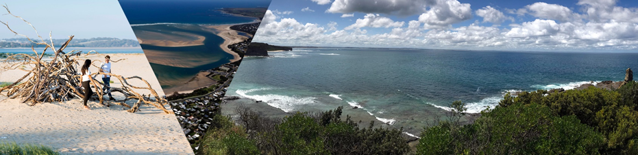
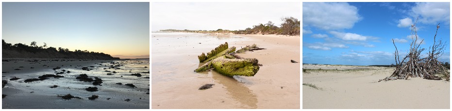
The coastline around Inverloch, Venus Bay and Anderson Inlet is a beautiful and dynamic part of the landscape. Natural processes such as winds, waves, tides, currents and catchment flows move sand and sediments, reshaping the coastline. These processes sometimes impact places we value, and the way we use the coast.
The coastline at and around Inverloch has experienced significant erosion in recent years. Public assets, values and infrastructure are now at risk of damage and loss.
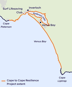
To proactively plan for managing future changes to the coastline, we’re delivering the Cape to Cape Resilience Project. This project combines the latest science, technical assessments and community aspirations to develop a long-term plan to manage important places, assets and other values in the future. The Cape to Cape Resilience Project study area is between Cape Paterson and Cape Liptrap.
This project is being undertaken in two key stages, you can find out more about each Stage below.

- Project Update #11 June 2025 - Community Engagement Findings - Draft Resilience Plan (PDF, 821.4 KB) | (Word) (DOCX, 11.0 MB)
- Inverloch Dune Reconstruction Beach Nourishment Project Update #1 April 2025 (PDF, 1.0 MB) | (Word) (DOCX, 3.2 MB)
- Project Update #10 August 2024 (PDF, 623.1 KB) | (Word) (DOCX, 6.0 MB)
- Project Update #9 July 2023 (PDF, 827.1 KB) | Word (DOCX, 3.5 MB)
- Project Update #8 Engagement Outcomes April 2023 (PDF, 2.2 MB) | Word (DOCX, 4.5 MB)
- Project Update #7 March 2023 (PDF, 823.9 KB) | Word (DOCX, 3.8 MB)
- Project Update #6 October 2022 (PDF, 1.1 MB) | Word (DOCX, 4.8 MB)
- Project Update #5 July 2022 (PDF, 1.0 MB) | (Word) (DOCX, 4.6 MB)
- Project Update #4 April 2022 (PDF, 726.6 KB) | (Word) (DOCX, 4.7 MB)
- Project Update #3 November 2021 (PDF, 525.0 KB) | (Word) (DOCX, 4.0 MB)
- Project Update #2 July 2021 (PDF, 677.4 KB) | (Word) (DOCX, 9.2 MB)
- Project Update #1 May 2021 (PDF, 868.4 KB) | (Word) (DOCX, 12.1 MB)
Inverloch Dune Reconstruction and Beach Nourishment Project Update #3 September 2025 (Word) (PDF)
Inverloch Dune Reconstruction Beach Nourishment Project Update #2 July 2025 (PDF, 618.6 KB) | Word (DOCX, 2.7 MB))
The Inverloch Regional and Strategic Partnership
Many agencies are responsible for managing coastal and marine areas. A Regional and Strategic Partnership (RaSP) brings these agencies together to respond to key issues. The Inverloch RaSP is the first RaSP established under the Marine and Coastal Act 2018. It has ten partners – Traditional Owners, the Bunurong Land Council Aboriginal Corporation, and nine agencies responsible for managing the Inverloch region's coastal land, assets and infrastructure.
The Inverloch RaSP will work with the community to address ongoing and future coastal erosion and inundation impacts. This includes delivering the Cape to Cape Resilience Project.
Project stages
Stage 1
From 2021 to 2022, we delivered Stage 1 of the Cape to Cape Resilience Project. This extensive scope of work produced various technical, strategic and engagement assessments. The outcomes of this work have allowed us to better understand the region’s coastal hazards and possible implications for our local communities, now and into the future. This work included:
- New research through a Coastal Hazard Assessment (CHA)
- Coastal hazard modelling, maps and spatial data layers
- Extensive community engagement and Community and Cultural Values studies
- A coastal risk and vulnerability assessment
- Economic base case for coastal hazards
More information about these outcomes can be found below.
The Inverloch Region Coastal Hazard Assessment (CHA) is a core technical investigation undertaken in the Cape to Cape Resilience Project. Informed by extensive analyses of the region's geological formation, local conditions, and historical and recent changes along the Cape to Cape coastline, the project team developed various computer models to simulate conditions of the local coastal, estuarine and catchment areas.
These models assessed:
- storm-tide
- waves
- sediment transport
- shoreline response (erosion/accretion).
The models have been used to examine how the coastline might change and respond by looking at both present day conditions and predicted future changes, such as rising sea levels and changing wind and wave climates.
This assessment's outcomes help us better understand some of the complex processes impacting our coastline and surrounding areas. As a result, we can now identify areas and assets that may be vulnerable to coastal hazards and changing climate conditions. This knowledge helps to inform the development of possible management or adaptation responses.
For more information about the CHA, check out these two presentations:
- Understanding the Coastal Hazard Assessment - a summary of the methods, modelling and key outcomes
- A strategic approach to adaptation - how the project team uses the outcomes to strategically plan our approach for managing coastal areas in the region.
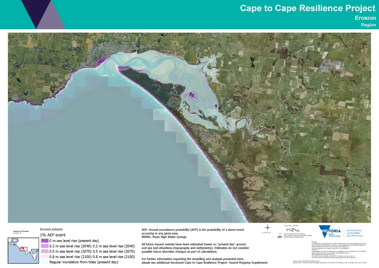
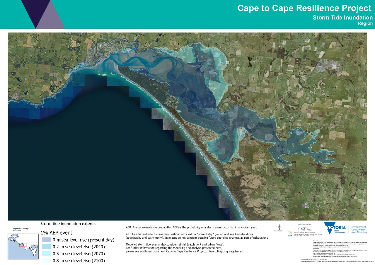
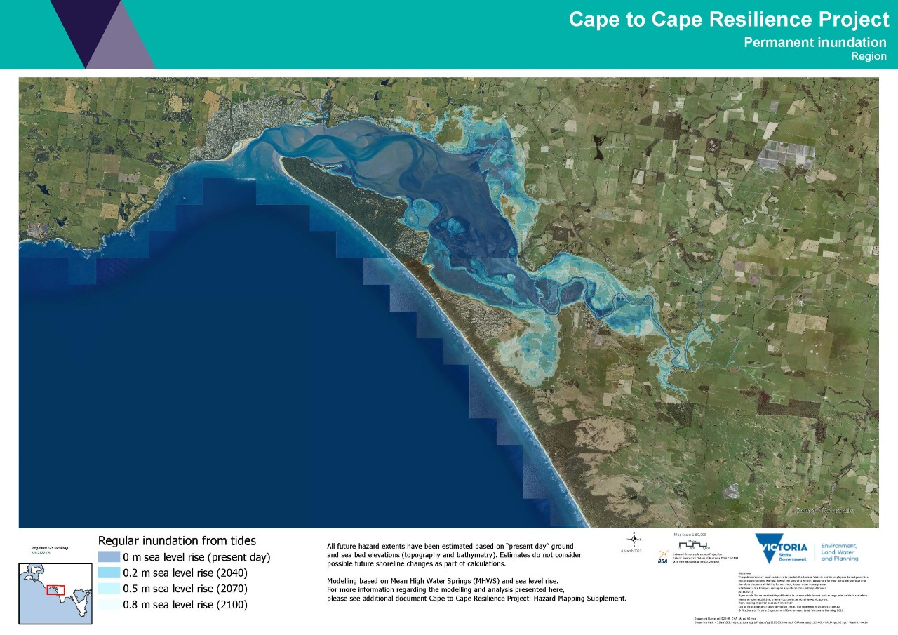
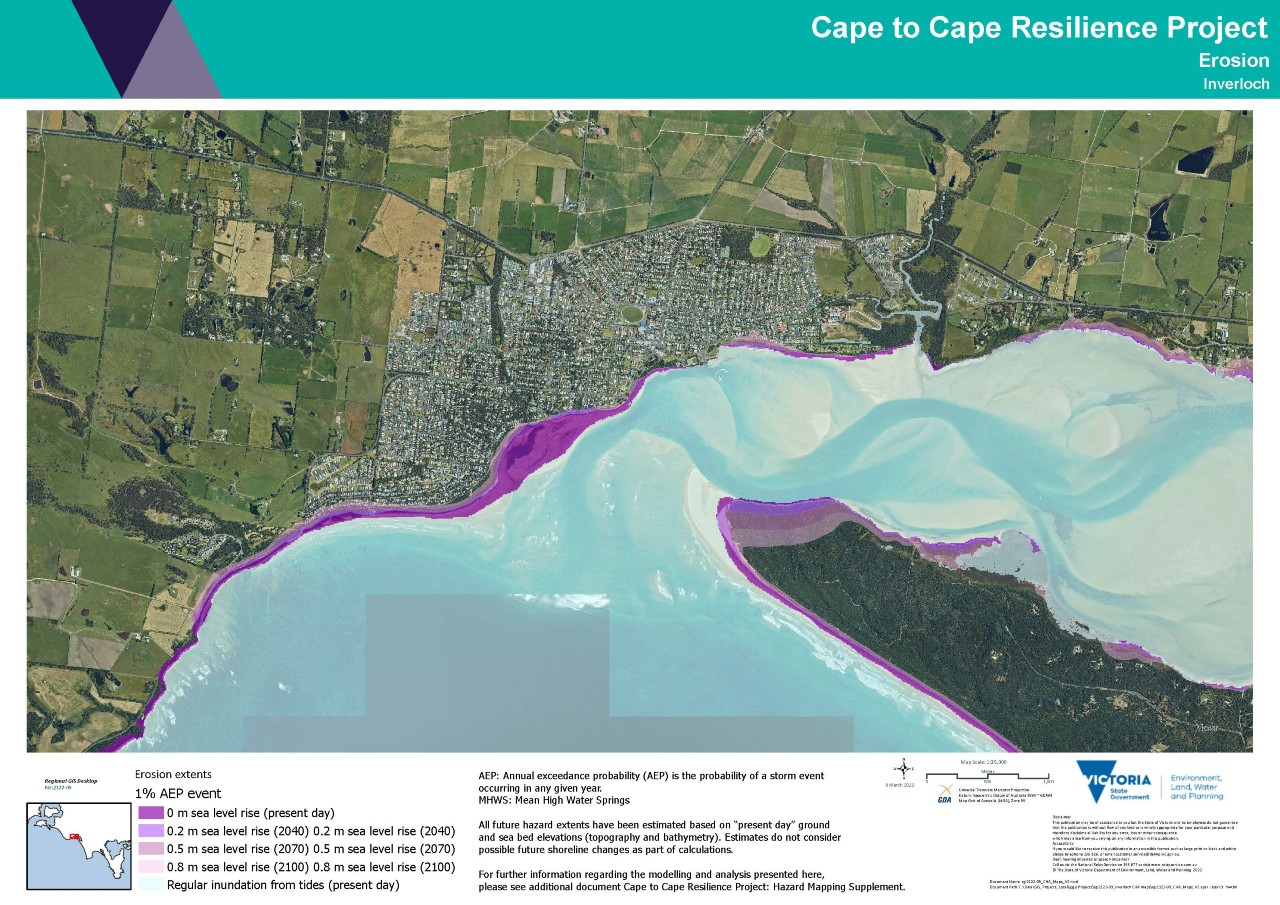
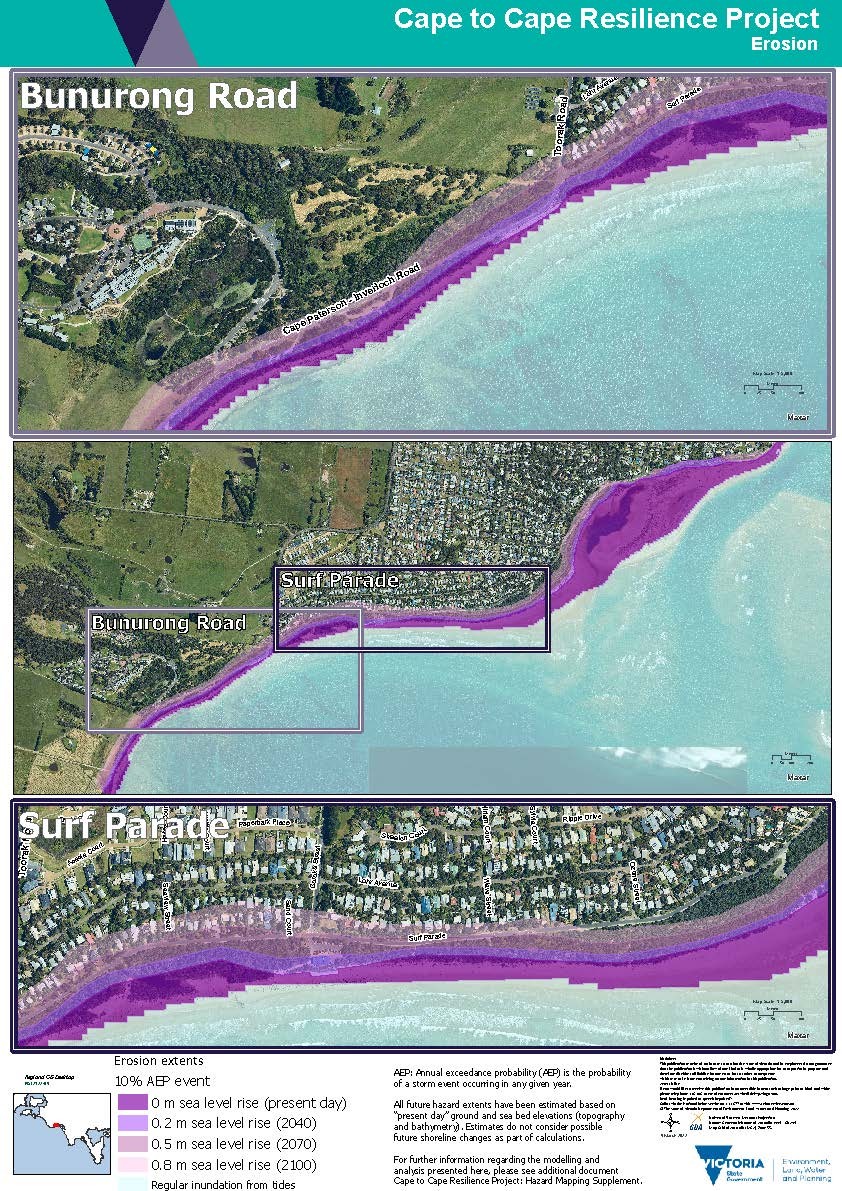
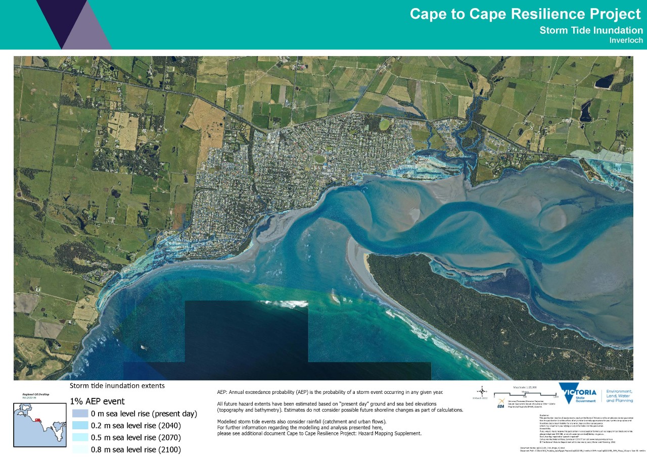
Hazard maps
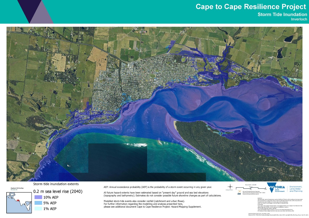
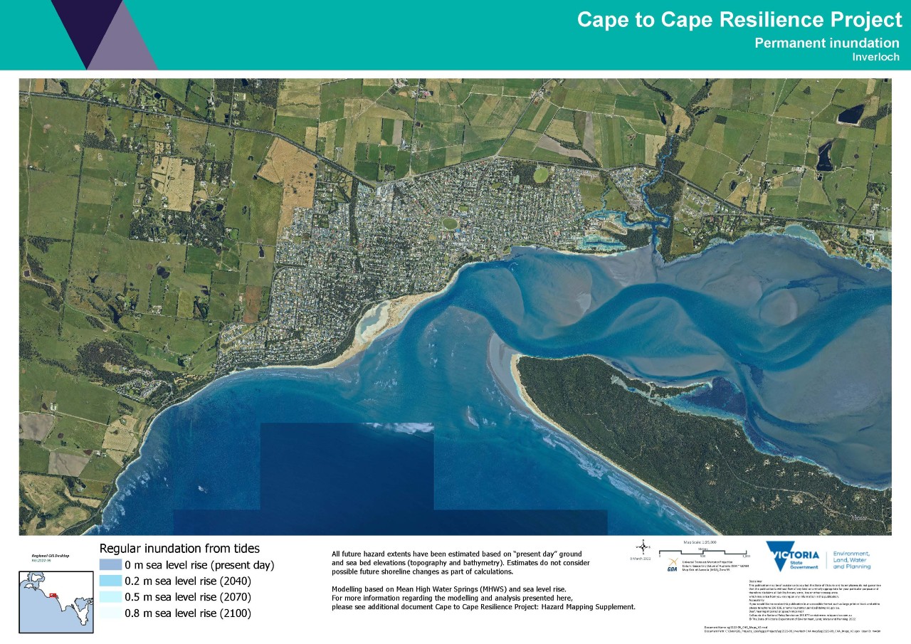
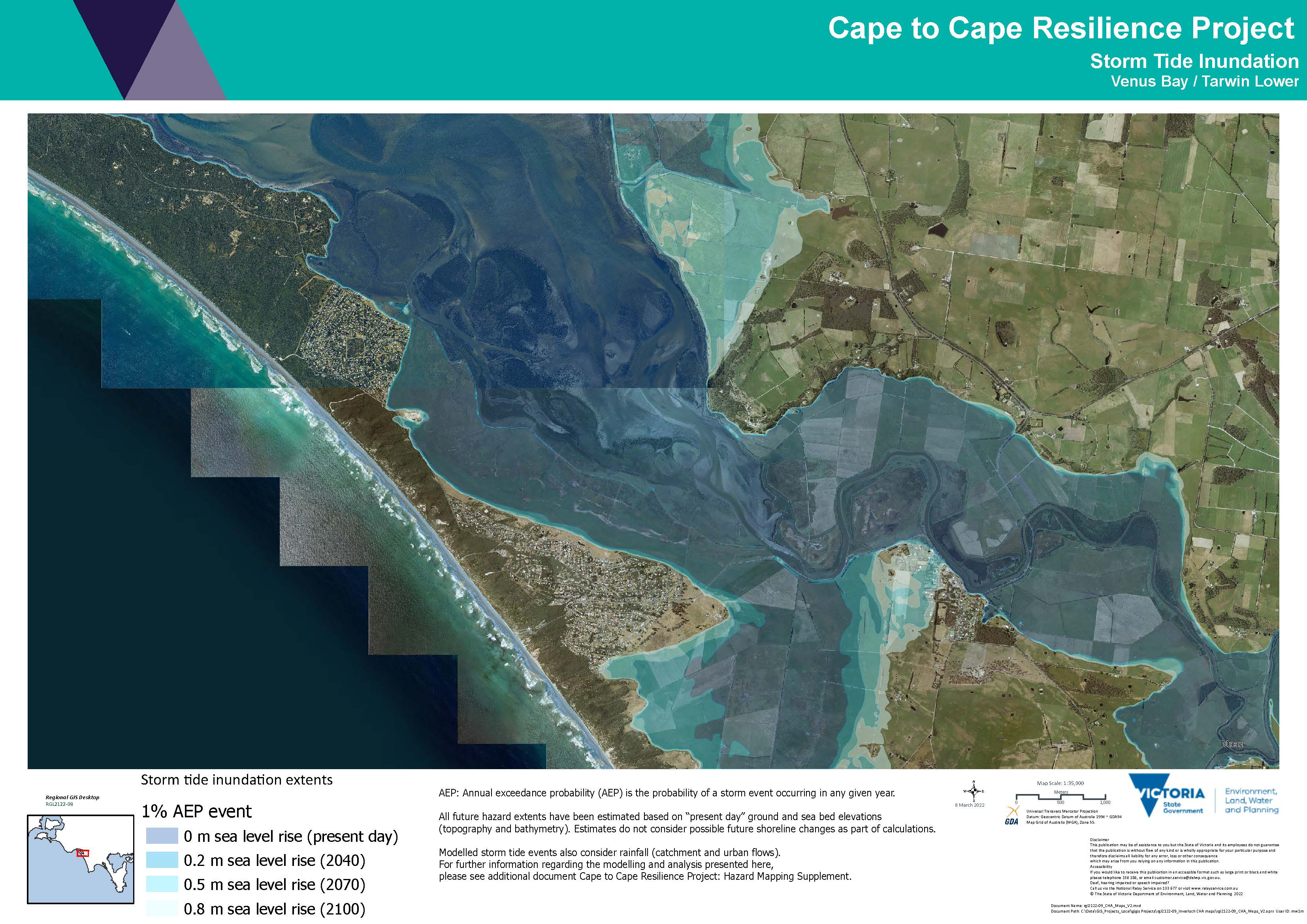
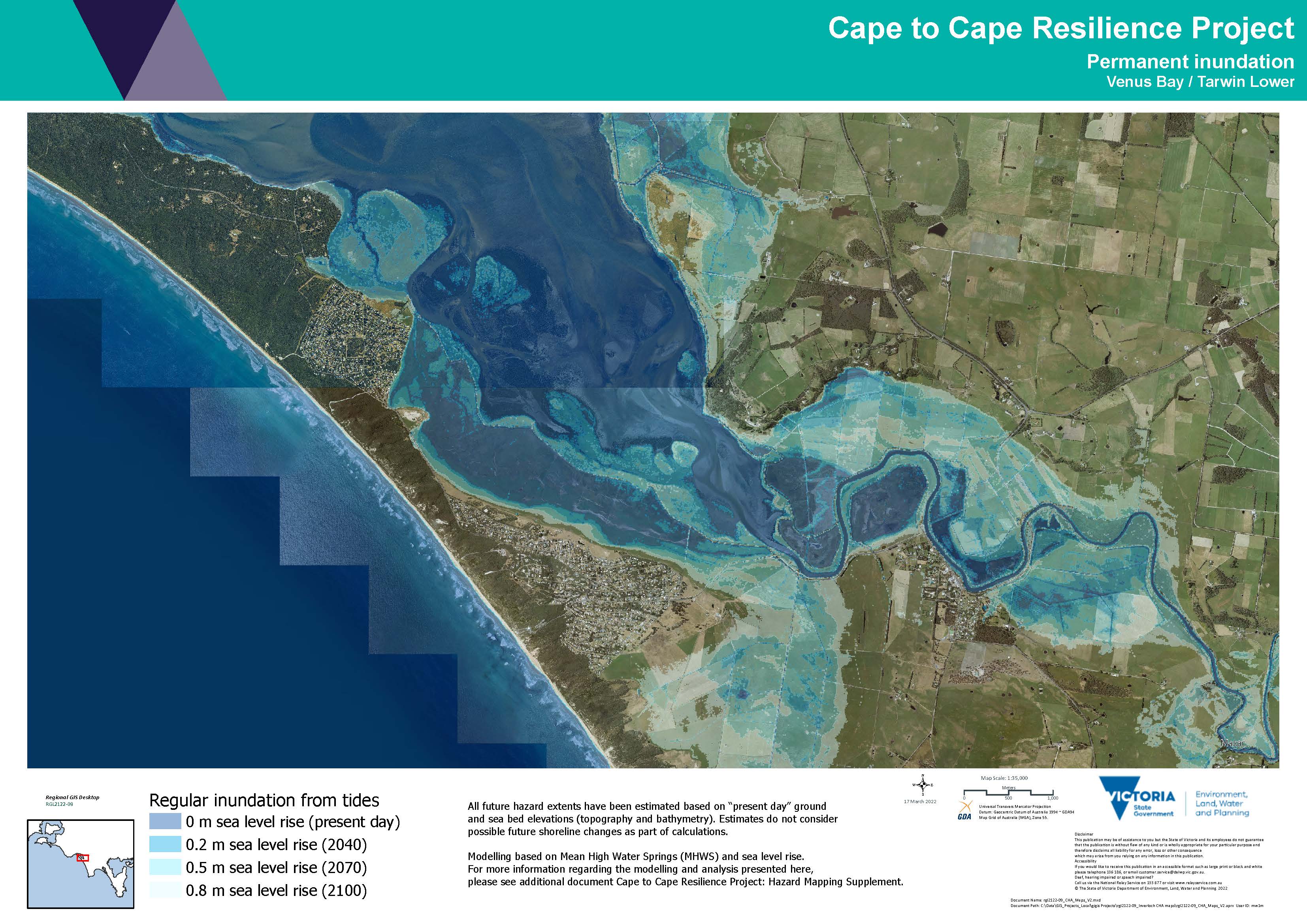
Estimated as 'coastal hazard extents', mapping the CHA modelling results indicates areas along the Cape to Cape coastlines that may be exposed to inundation (flooding), erosion (sand loss) or sea level rise.
Many maps have been produced by the project team, showing combinations of the different hazard types, storm events and timeframes. This helps to highlight how hazards and exposure varies for each hazard type, storm events, climate conditions and over different timeframes. This spatial understanding informs our understanding of exposure, vulnerability and risk.
You can view the hazard maps below. Be sure to read the Hazard Map Information Sheet for more information about the maps and how they help us to plan for the future.
- Hazard Map Information Sheet (Word)/(PDF)
- Cape to Cape Region Erosion Hazard Map_1% AEP (JPG)/(PDF)
- Cape to Cape Region Storm Tide Inundation Hazard Map_1% AEP (JPG)/(PDF)
- Cape to Cape Region Storm Tide Permanent Inundation Hazard Map (JPG)/(PDF)
- Inverloch Erosion Hazard Map_1% AEP (JPG)/(PDF)
- Inverloch Erosion Hazard Map - Bunurong Road and Surf Parade_10% AEP (JPG)/(PDF)
- Inverloch Storm Tide Inundation Hazard Map_1% AEP (JPG)/(PDF)
- Inverloch Storm Tide Inundation Hazard Map AEP Storm (JPG)/(PDF)
- Inverloch Permanent Inundation Map (JPG)/(PDF)
- Venus Bay & Tarwin Lower Storm Tide Inundation Hazard Map_1% AEP (JPG)/(PDF)
- Venus Bay & Tarwin Lower Permanent Inundation Hazard Map (JPG)/(PDF)
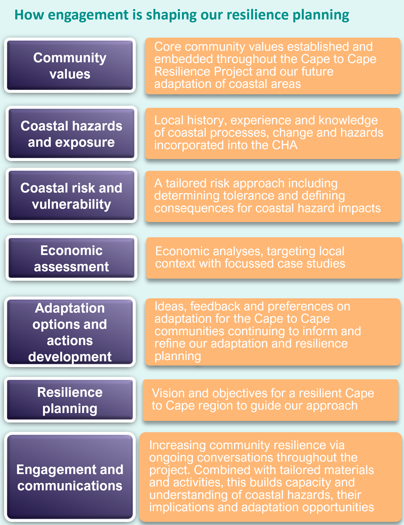
The Community Values Study is a key initial study for the Cape to Cape Resilience Project. It provides a basis for better understanding the community’s values, priorities and perspectives in the context of adaptation and resilience planning for the coastal areas of the Cape to Cape region
Data that informed the Community Values Study came from an extensive engagement process between July and September 2021.
You can find the full details of this engagement in our Community Values Study, or a snapshot of the findings below:
Values and Experiences Survey (Snapshot) October 2021 (Word)/(PDF)
Community Values Study December 2021 (Word)/(PDF)
Community Engagement: Adaptation Survey Outcomes (Snapshot) April 2022 (Word)/(PDF)
Technical and Strategic Assessment
Read the full suite of technical and strategic reports from Stage 1 below:
- Economic Assessment Economic Case Studies
- Adaptation Framework Paper
- Risk and Vulnerability Report
- IRCHA Additional Data and Adaptation Option Review
- IRCHA Summary Report
- IRCHA Data Assimilation & Gap Analysis
- IRCHA Technical Methodology
- IRCHA Coastal Processes Part #1
- IRCHA Coastal Processes Part #2
- IRCHA Coastal Processes Part #3
- IRCHA Coastal Processes Appendix B
- IRCHA Coastal Processes Appendix C
- IRCHA Inundation Hazard Assessment
- IRCHA Coastal Asset Exposure Assessment
- IRCHA Adaptation Action Technical Assessment
We have also created summaries of the key reports to help communicate the key work and findings of the project:
Stage 2
We are now working through the final components of Stage 2, the development of the Cape to Cape Resilience Plan.
Formed over two years, agencies, stakeholders and communities collaborated to create the plan, which provides a roadmap to build resilience across communities and adapt to coastal hazards both now and into the future.
The Cape to Cape Resilience Plan includes:
- An overview of Statewide marine and coastal policy, adaptation planning guidance, and the journey to develop the Resilience Plan
- An understanding of the Cape to Cape coastal landscape, communities, and values
- Coastal hazard modelling and mapping results from the Coastal Hazard Assessment
- Exposure and risk assessment results, including vulnerability and economic assessments
- A strategic approach to adaptation, including adaptation pathways and foundational, regional and location-specific actions
The final Cape to Cape Resilience Plan will be released in the coming months following incorporation of community feedback and endorsement by the Inverloch Regional and Strategic Partnership.
Resilience Plan Frequently Asked Questions
No, the erosion is within the present-day hazard zone for the area. The image below shows the modelled erosion hazard on Inverloch Surf Beach for a 10% (1 in 10 year) event under present-day sea-level conditions. In some areas the recent storms did erode the beach and dunes as far landward as this model predicted, but in many sections the dunes have not eroded that far.
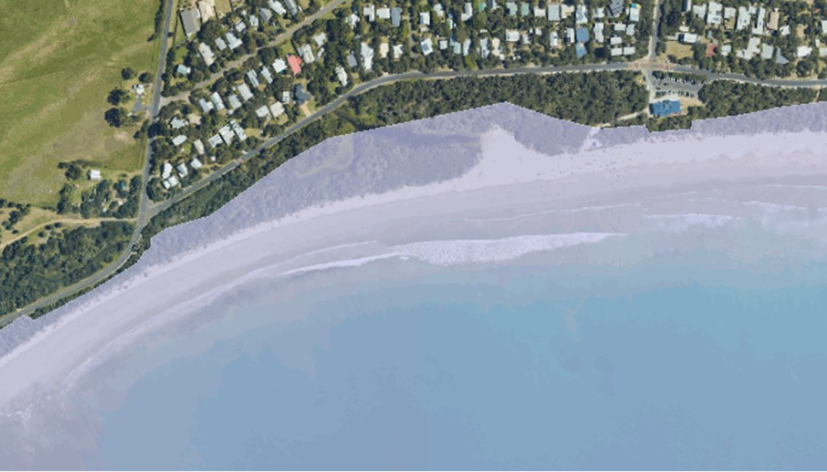
Image: Inverloch Surf Beach erosion 10% Annual Exceedance Probability (AEP), present day
Source:https://mapshare.vic.gov.au/coastkit/
Go to the CoastKit portal (https://mapshare.vic.gov.au/coastkit/) to explore the hazard layers modelled for the Inverloch Region Coastal Hazard Assessment. Tick the ‘Coastal Hazard Assessment’ box, then ‘Local Study Data Sets’ and ‘Inverloch LCHA 2021’. From there you can select the type of hazard, when it is likely to occur (present day/2040/2070/2100) and move the slider to make the layers more transparent.
Note that inundation layers are based on 2021 topography – coastline changes such as erosion will alter where storm-driven inundation can reach.
In feedback received during the project’s many types of community consultation (various surveys, drop-in sessions, pop-ups, markets, and roundtables), the local community expressed strongly that the natural beach and coastal landscape of Inverloch is what they value the most about Inverloch’s coast. It is a significant recreational and tourism asset, and losing the beach would have wide ranging negative impacts on the town’s amenity, liveability and economy.
A rock revetment, like the one at Cape Paterson-Inverloch Road, will cause erosion in front of it, lowering the beach level. It will not help sand to stay on the beach. This would mean that Inverloch Surf Beach is only useable at low tide. The ends of the wall would behave just like the sandbag seawall, eroding the dune either side during storm events. Extending the wall to make it longer would just move the problem further either side because there is no natural hard headland to tie it into.
This type of large-scale engineering option is not viable for Inverloch for a number of reasons – mainly environmental and economic.
The Gold Coast’s ‘A-line seawall’ is an enormous structure (12.5m wide x 8m high) and extremely expensive to build. Property owners are responsible for the cost of building and maintaining it when they develop the adjacent land. Building one like that at Inverloch would likely cost more than $50 million and would ruin the beach amenity that we’ve been told the community wants to retain.
The beaches of the Gold Coast are almost entirely artificial. They require constant nourishment at significant expense, which is mainly paid for by local businesses.
The Gold Coast’s most recent large scale nourishment was done in 2017 before the Commonwealth Games and cost nearly $20 million. There are hundreds of millions of cubic metres of sand offshore of the east coast of Australia, and it naturally moves north up the coast. The ready sand supply is regularly dredged, and sand is pumped ashore. More sand is pumped north by the sand bypass systems, such as at Tweed Heads, which costs around $10 million annually to operate.
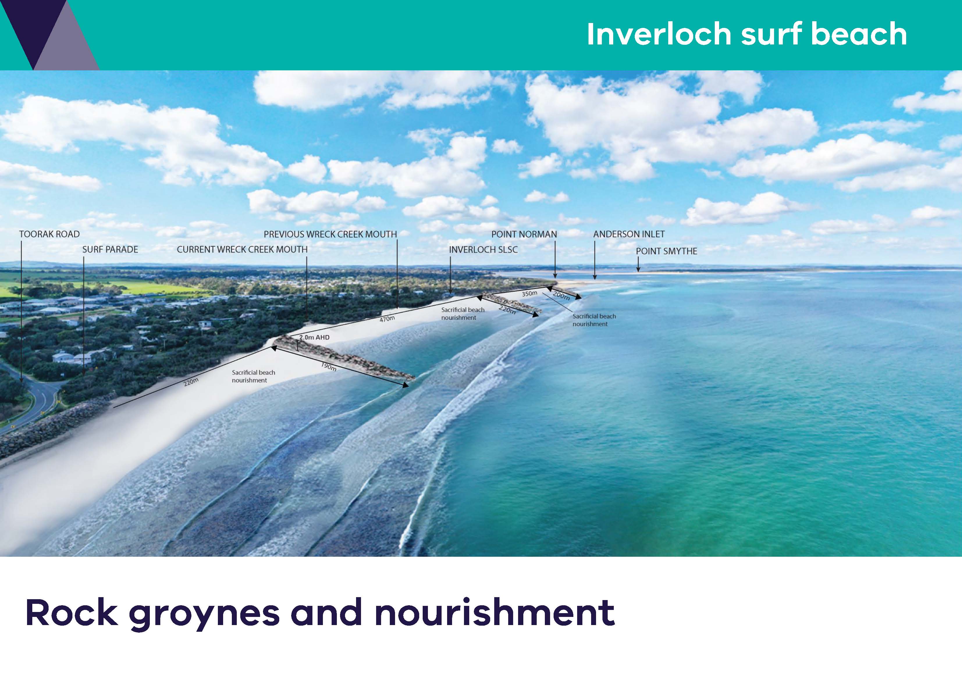
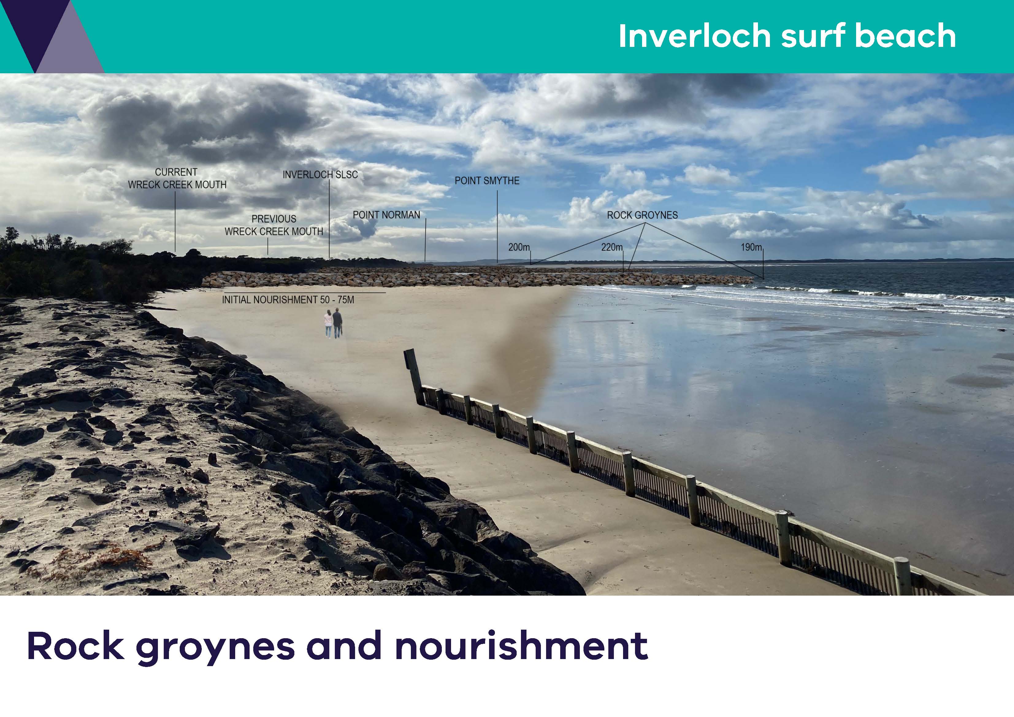
A rock groyne at Point Norman would stop sand moving east into Anderson Inlet. It would not stop sand being eroded and shifting offshore from Inverloch Surf Beach during storm events.
The modelling indicates that a rock groyne would need to be around 300 - 500m long to work properly with the length of the beach and help keep sand in front of the Inverloch Surf Life Saving Club. A deep channel would form on the inlet side of the groyne, causing increased currents and making it unsafe for many water activities. The deep channel would likely undercut the base of the groyne and destabilise it. It would cost around $45 million to build, and beach nourishment would also be required.
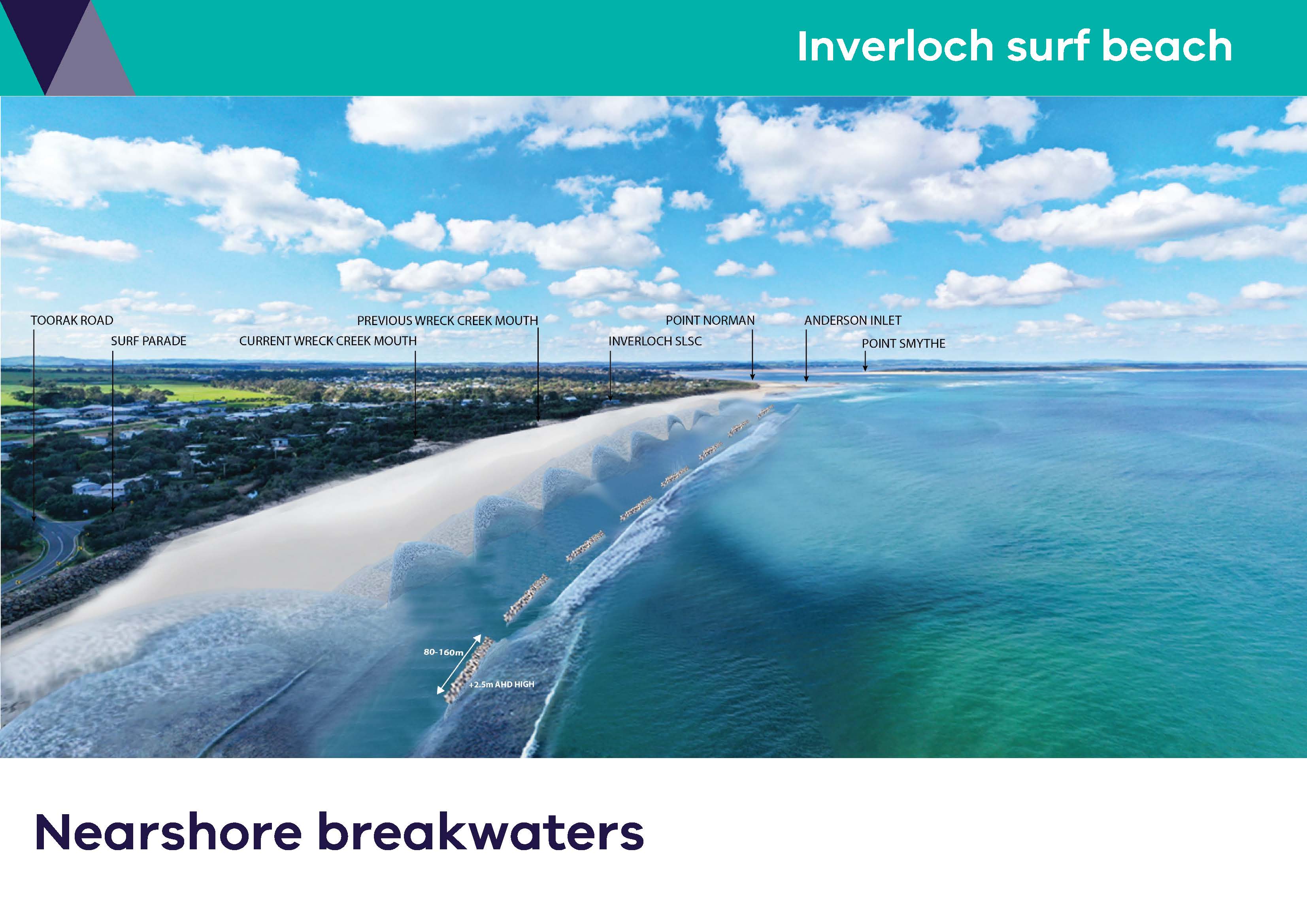
Offshore breakwaters would need to be so large that they would always be visible above the water from the beach, even at high tide. They would block the view to the ocean from the beach, significantly impacting beach amenity. They would cost around $40 million to build and would also require beach nourishment. By design, they would change the local wave conditions, meaning they would also impact on the recreational amenity, and the ability to surf in these areas.
There is a range of valuable monitoring activities happening at Inverloch Surf Beach and the surrounding Cape to Cape region. These include measuring sand movement, beach and seabed elevations, wave conditions and water levels, and allow us to track change and how the beach and coastal areas respond to certain weather conditions and storm events. We can also use this information to help validate, refine and improve our coastal models.
DEECA leads a citizen science program which flies drones approximately every six weeks to monitor sand movement and shoreline changes on Inverloch Surf Beach. This is part of the Victorian Coastal Monitoring Program.
For over 5 years the South Gippsland Conservation Society has been taking measurements of the location of the dunes and the beach at low tide along the beach from Point Norman to Flat Rocks and reporting on changes.
Gippsland Ports regularly carries out hydrographic surveys of the seabed in Anderson Inlet, the entrance and outside the entrance.
Deakin University has a ‘Vic Waves’ wave buoy offshore in Venus Bay which measures things like wave heights and frequency. For around three months in 2022-3 a second wave buoy was installed nearshore at Surf Beach which helped to validate and calibrate the coastal hazard models.
Transitioning the way land on the coast is zoned and used enables public land to be maintained for access for all Victorians. As sandy beaches and dunes erode due to coastal processes and hazards including sea level rise, what is presently public land will get narrower until in some locations, there is none. This will mean that there is less and less beach for the public to use, and the coastal dunes will no longer provide a natural protective buffer to public and private assets behind them. If we transition land use by relocating assets away from the hazard areas, we can maintain public coastal land into the future.
This problem is affecting many sandy shorelines around the world where people have built assets close to the coast. There are many ideas for how land use transition (or retreat) can be done, and governments worldwide are tackling this in various ways. The Australian and Victorian governments don’t yet have a strategy on how to approach and implement retreat, but some options, like land buy backs/swaps/lease back arrangements, are outlined in the Victoria’s Resilient Coast: adapting to 2100+ Adaptation Actions Compendium and will be explored further during the policy development project.
The Victorian Government has recently been awarded a Commonwealth grant to work with local coastal governments on developing retreat policies to improve climate change adaptation and resilience. So exactly how governments can do retreat on the coast is still be investigated. We can draw from experiences in other sectors - such bushfire hazard zones and critical infrastructure projects, in shaping a retreat approach for at-risk coastal areas.
The government does not control the property market, and the market doesn’t necessarily reflect land use planning and known or expected future hazards. Land use transition is identified in the Cape to Cape Resilience Plan’s adaptation pathways for the period beyond 2040. By 2070, some parts of coast will be so impacted by coastal erosion or inundation (sea level rise) that assets will need to have retreated or they will be damaged too frequently or lost. Hazards will not only impact individual properties, but also key services that support these properties (i.e. water, sewerage, gas, electricity) and reliable and safe access. This will significantly compromise liveability and public safety.
If, how or when property values are impacted by changes to land use (such as development controls or planning scheme overlays) is hard to say. It is up to potential buyers to undertake their due diligence when purchasing property, and many may not be bothered by controls that extend so far into the future. We already see this with properties included in Land Subject to Inundation Overlays, which include many residential areas of Inverloch.
The two local government RaSP partners have committed to working with the Victorian Government to ensure coastal hazards identified through the project are reflected in the planning systems, through a range of mechanisms that are still being explored. This may include planning scheme overlays and building and development controls and rezoning of land. These planning instruments are an important part in helping to avoid poor decisions that have lasting and costly impacts such building in, developing and investing in areas that are increasing at risk into the future.
Triggers are an important tool in adaptation planning. They can be used to indicate when a change in management is required, prompting us to alter what we are doing to mitigate coastal hazard risk. This might be a change in environmental conditions, a shift in levels of risk, changes in community sentiments or risk tolerance or new/extra information available to inform our understanding and decision making.
The detailed adaptation pathways in the plan identify some triggers but triggers for the many different localities in the Cape to Cape Resilient Plan will be further developed by relevant working groups of land and asset managers. Triggers will need to be tailored for different areas across the Cape to Cape region. They also require review and may need to be updated or revised over time.
For the Cape to Cape region, possible triggers include setting erosion distances, such as the coastline recedes to a particular distance from an asset; others may be the number of days/year that an asset like a key access road is inundated or a set number of storms occurring in close succession.
Adaptation can be defined as 'the process of adjustment to actual or expected climate and its effects’.
A range of actions can be considered for mitigating coastal hazard risk and adapting to climate change. These may include activities associated with planning, capacity building, engineering, or other themes.
In considering options to mitigate coastal hazard risk, the Victorian Marine and Coastal Policy (2020) provides direction to respect natural coastal processes, apply an adaptation pathways approach, and consider options in the following order:
- non-intervention
- avoid
- nature-based methods
- accommodate
- retreat
- protect.
More information about the approach to adaptation and these options can be found in Factsheet #6 Strategic Approach to Adaptation and Factsheet #7 Adaptation Action.
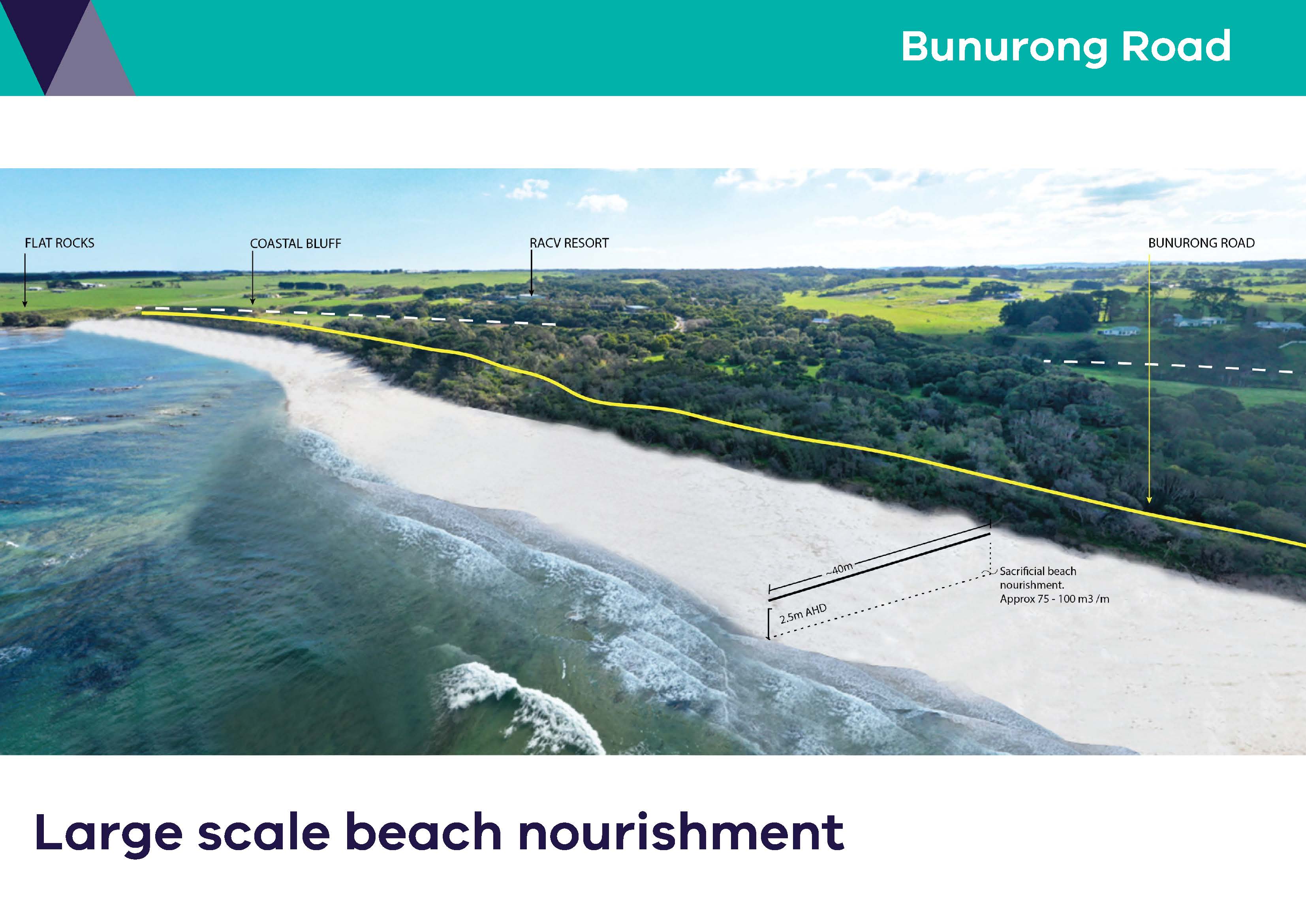
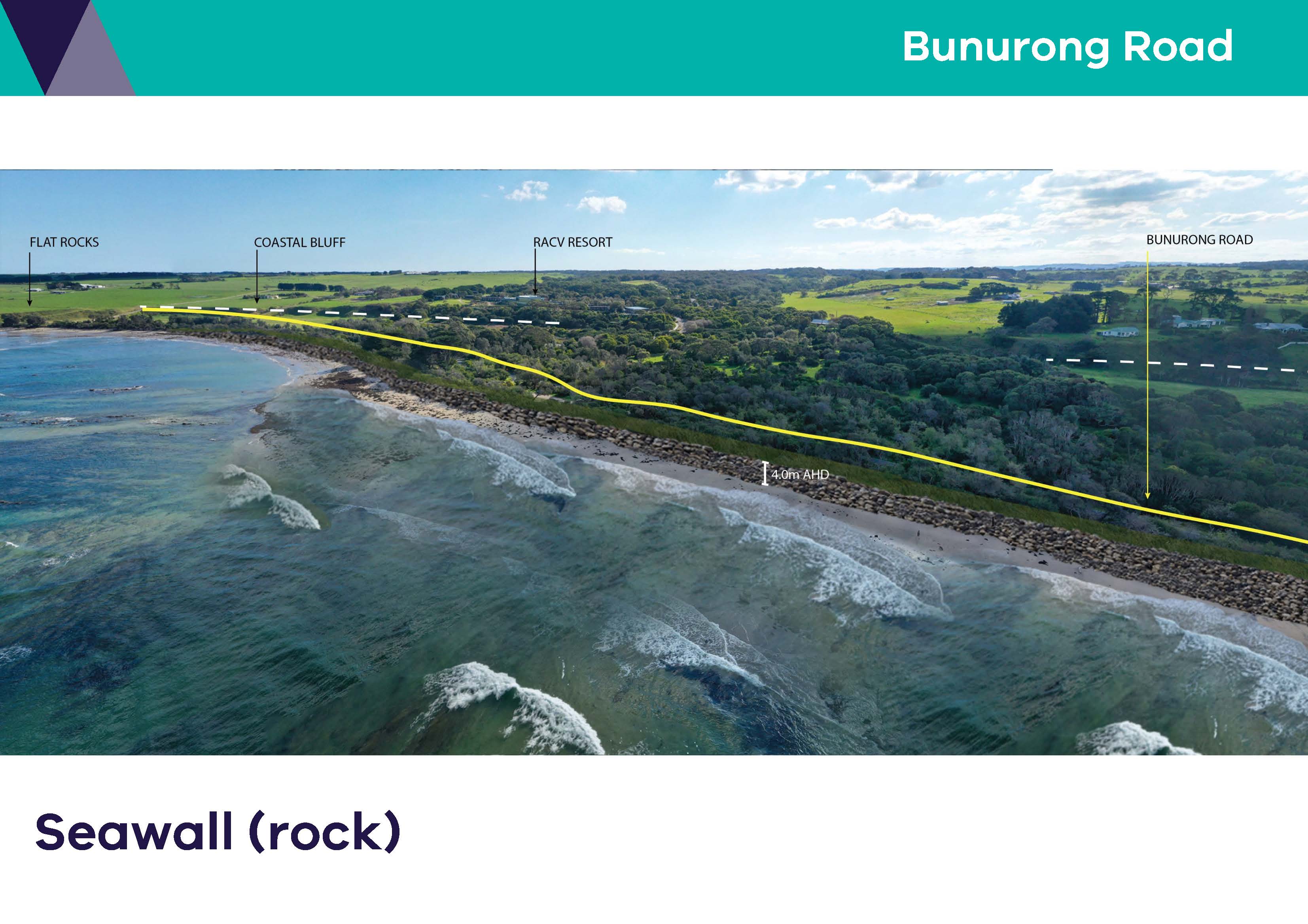
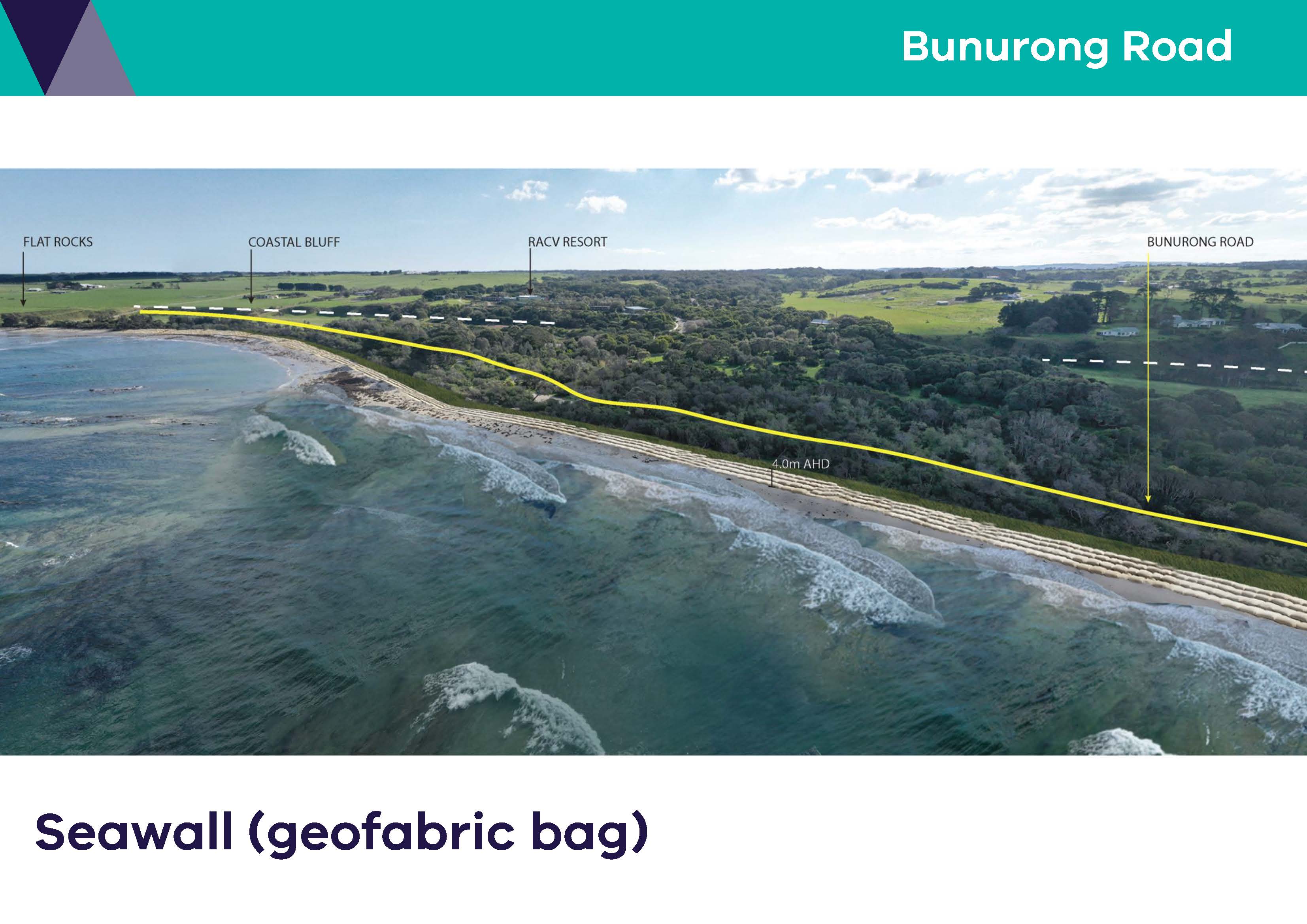
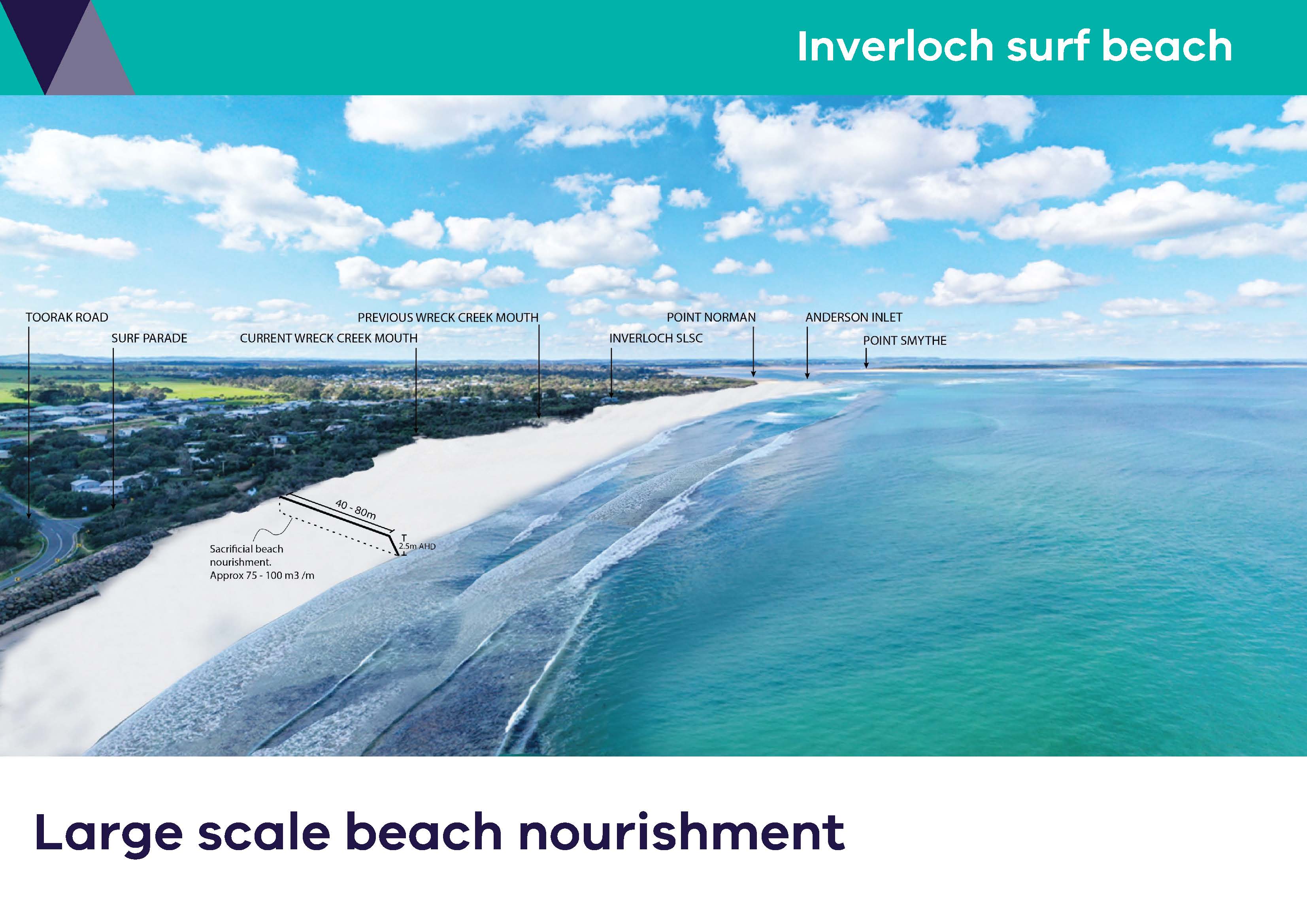
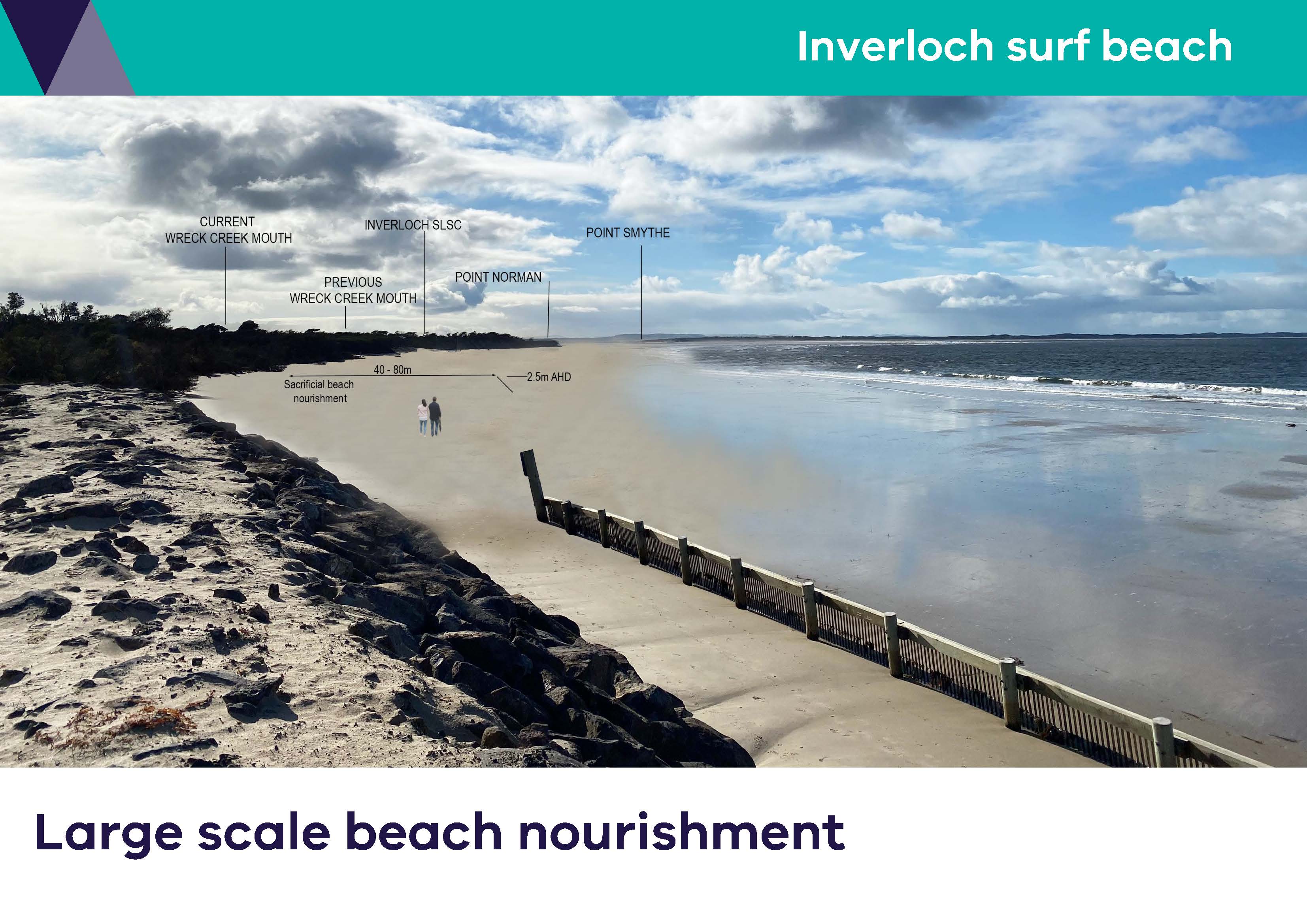
Photo Montages
Static visualisations of engineering adaptation options, as identified within the Adaptation Action Technical Assessment of the Inverloch Region Coastal Hazard Assessment. The below photo montages are based on conceptual designs proposed within the report, presenting visual aesthetic impacts the adaptation options would have on the coastal environment. *Noting that detailed designs have not yet been developed.
Large scale beach nourishment Bunurong Road (JPG)/(PDF)
Rock seawall Bunurong Road (JPG)/(PDF)
Geotextile sandbag seawall Bunurong Road (JPG)/(PDF)
Large scale beach nourishment Inverloch Surf Beach - aerial view (JPG)/(PDF)
Large scale beach nourishment Inverloch Surf Beach - beach level/oblique view (JPG)/(PDF)
Rock groynes and nourishment Inverloch Surf Beach - aerial view (JPG)/(PDF)
Rock groynes and nourishment Inverloch Surf Beach - beach level/oblique view (JPG)/(PDF)
Geotextile sandbag groynes and nourishment Inverloch Surf Beach - aerial view (JPG)/(PDF)
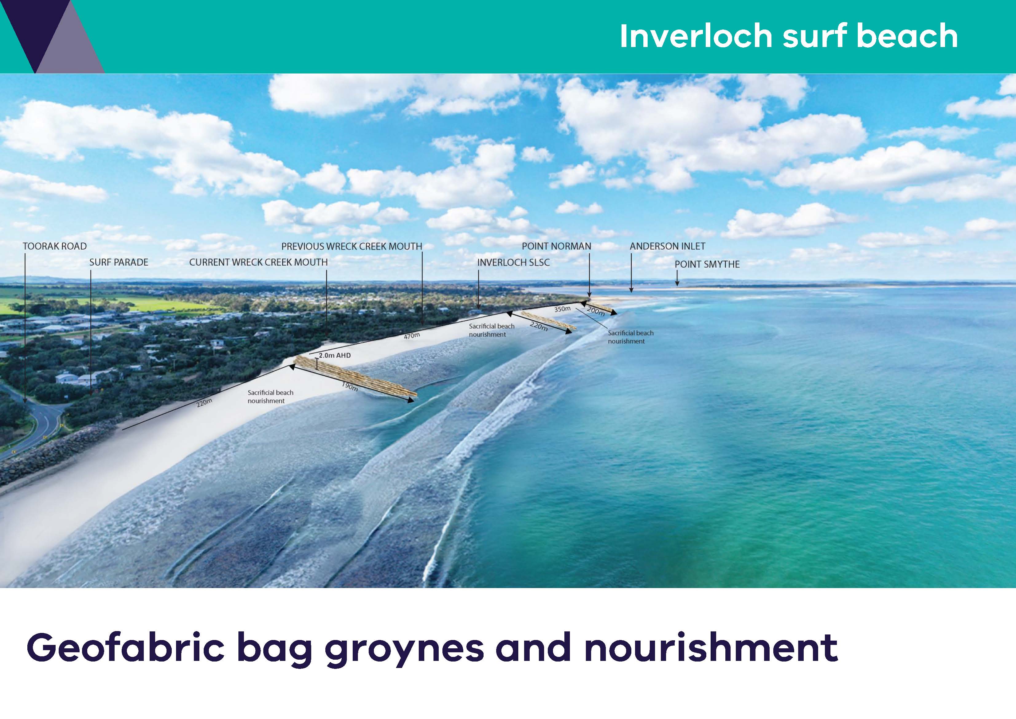
Geotextile sandbag groynes and nourishment Inverloch Surf Beach - beach level/oblique view (JPG)/(PDF)
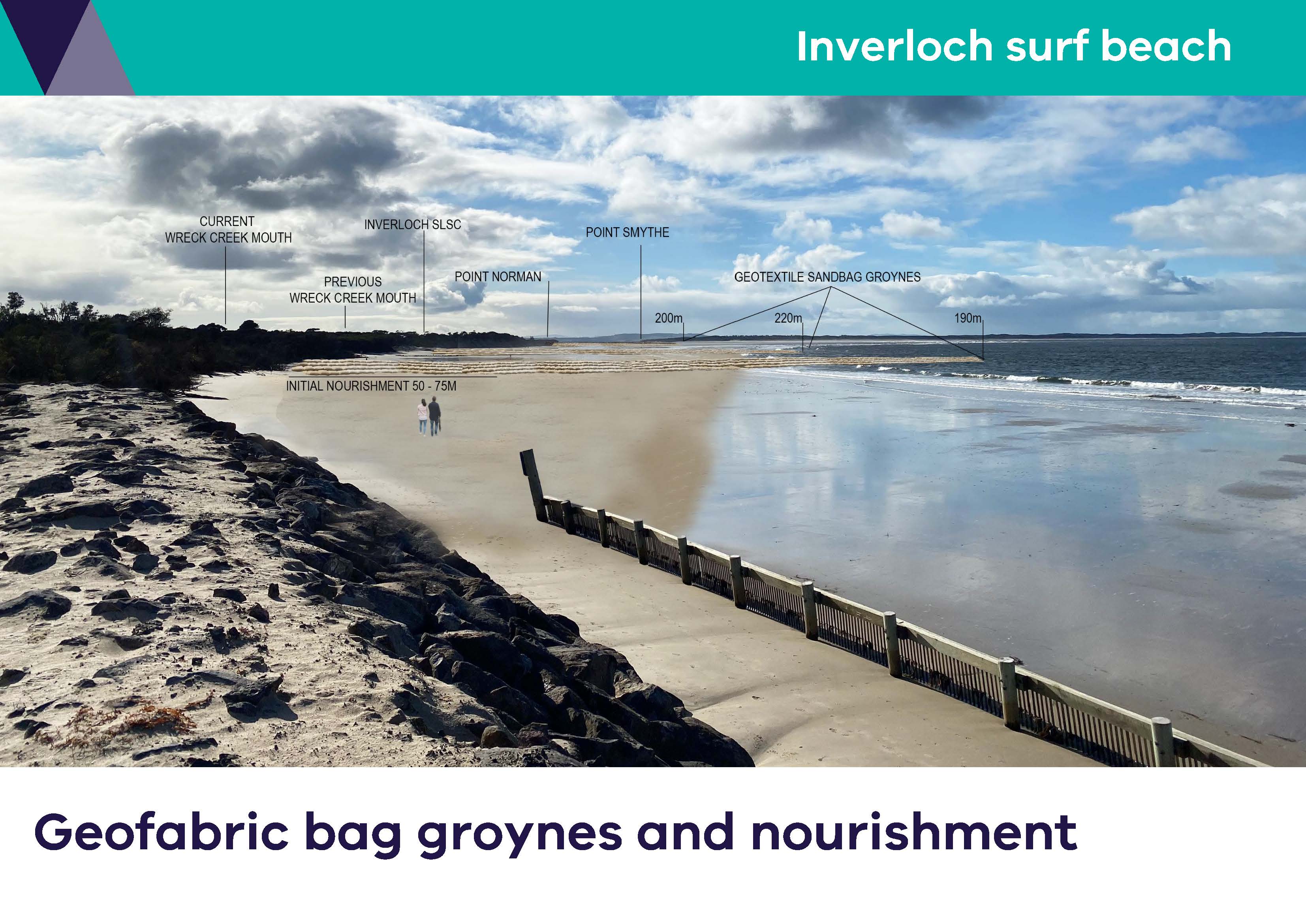
Long rock groyne Point Norman Inverloch Surf Beach - aerial view (JPG)/(PDF)
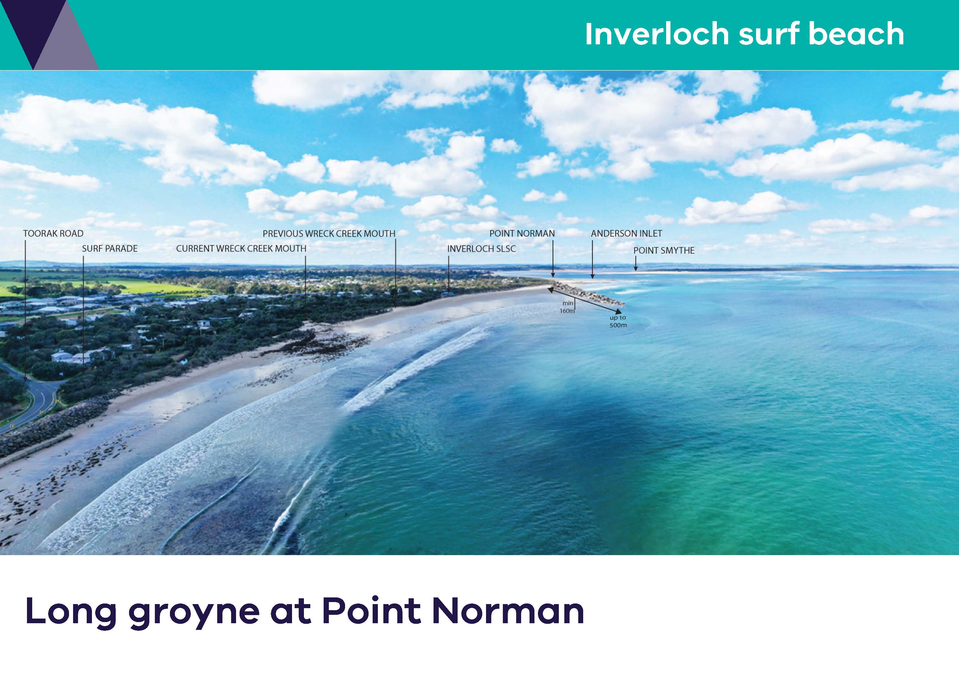
Long rock groyne Point Norman Inverloch Surf Beach - beach level/oblique view (JPG)/(PDF)
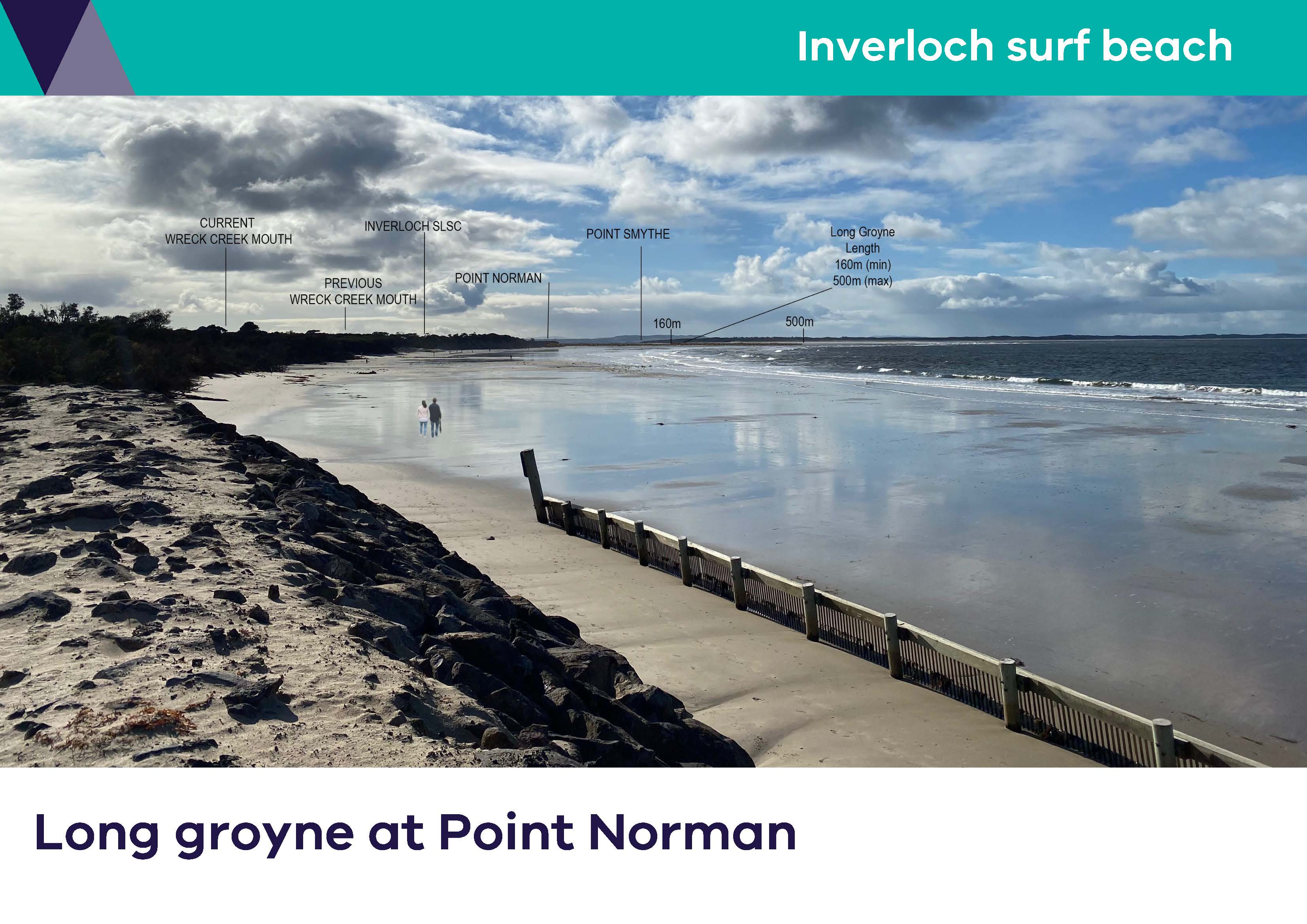
Listening to the community
Speaking with our community is key to the Cape to Cape Resilience Project. Our stakeholder and community engagement is happening throughout the project and will be tailored to align with and inform key elements of the technical work.
As our project team continues with our adaptation and resilience planning, we will also continue talking to our key stakeholders and community.
Engagement to date
Our work to date has already explored a range of topics relating to coastal hazards and their management with our community:
- community values, usage and enjoyment of the Cape to Cape region’s coastal areas
- perceived threats to these values and uses
- what the community hopes to see in the future
- ideas, perspectives and preferences that may enable us to adapt and increase our resilience
How to participate
Hearing ideas and perspectives from the Cape to Cape communities remains an important part of this project and will help shape the region's adaptation pathways and actions.
Extensive and targeted community and stakeholder engagement was completed throughout Stage 2, to help inform our Resilience Plan. Visit our Engage Victoria page for the latest information on how you can participate.
Email capetocape.project@delwp.vic.gov.au to receive project updates.
Project Frequently Asked Questions
The Cape to Cape Resilience Project is a coastal hazard adaptation project, overseen by the Inverloch RaSP. The project includes:
- new research through a Coastal Hazard Assessment
- extensive community engagement
- a coastal risk and vulnerability assessment, and
- coastal resilience planning.
In response to erosion experienced along the Inverloch foreshore, coastal hazard adaptation options will initially focus on the 5 km coastline from Flat Rocks to Screw Creek.
Working with the RaSP agencies, the project team will consider a range of adaptation options for this stretch of coastline. The Inverloch Coastal Hazard Assessment, risk assessments, and community values and adaptation preferences will inform the development of possible options.
Using tailored objectives and criteria, we will shortlist options to examine further. Criteria will include community values, environmental impacts, costs, performance and effectiveness, and amenity (including impacts on access and aesthetics). Importantly, the order of consideration for options must also align with the directions for managing coastal hazard risk outlined in the Victorian Marine and Coastal Policy (2020).
A detailed analysis of the shortlisted options will draw on modelling, economics, and strategic planning to determine actions for Flat Rocks to Screw Creek and inform adaptation planning for the broader Cape to Cape coastline and communities.
Computer models will test the performance and suitability of different adaptation options (interventions) under different scenarios. Up to 5 adaptation interventions will be modelled to determine their effectiveness in mitigating hazard risk and considering potential impacts on surrounding areas.
We will assess options for present-day and future conditions to ensure they are appropriate now and how long they will be effective. Short, medium and long term actions can then be included in the adaptation planning process.
While we plan, develop and design adaptation solutions, the Inverloch Coastal Protection Interagency Working Group continues actively monitoring the coastline to determine if further short-term, rapid response/management measures are required.
The project provides many different and exciting opportunities for the community and stakeholders to be involved.
Using a range of in-person and online activities and events, we will be looking to share key information from the project. We are also keen to gather your insights into what you value about the coast from Cape Paterson to Cape Liptrap, and your perspectives on adaptation and resilience.
We will be providing regular updates and factsheets to keep you informed about the project.
The study area for the Cape to Cape Resilience Project is between Cape Paterson and Cape Liptrap on the Bass Coast, Gippsland.
The area of interest includes:
- The open coast from Cape Paterson along the coastal cliffs adjacent towards Inverloch
- The open foreshore and surf beach at Inverloch
- The dynamic estuaries and tidal mudflats of Anderson Inlet
- The open coast and dunes of Venus Bay south to Cape Liptrap
- Inland from the coastline, allowing for assessment of estuary and groundwater impacts.
There will be a range of project outputs, including:
- the Inverloch Region Coastal Hazard Assessment (CHA)
- a Community Values Study
- coastal risk and vulnerability assessment
- the Cape to Cape Coastal Resilience Plan.
The expected outcomes of the Cape to Cape Resilience Project include:
- identification of coastal hazards from Cape Paterson to Cape Liptrap and the extent of potential impact
- inundation, erosion and groundwater data and hazard mapping for the region
- stakeholders have up-to-date information to inform planning decisions and management of assets
- community values influence the direction of the research, management strategies and resilience planning.
- community understanding of local coastal hazards and management strategies.
Natural coastal processes like wind, waves, tides and currents work to shift sediment and shape the coastline. When these processes negatively impact on use of the coast, they become coastal hazards. These impacts could be environmental, social, cultural or economic impacts. Coastal hazards include coastal erosion and inundation.
The Coastal Hazard Assessment will consider:
- wind and wave conditions
- sediment transport
- coastal erosion
- permanent and temporary inundation (coastal and flooding), and changes in groundwater
- multiple sea level rise scenarios for storm and rainfall impacts will be modelled. Proposed scenarios are 0.2 m, 0.5 m, 0.8 m, 1.1 m and 1.4 m of sea level rise.
This new research will:
- assess present day conditions,
- calibrate models against historic events, and
- predict conditions for the future.
We’ll also look at different magnitudes of coastal storm events and potential changes in wind and wave direction.
Water Technology will undertake the Coastal Hazard Assessment and technical investigations.
The South Gippsland Conservation Society has been working on the Inverloch Coastal Resilience Project (ICRP) since 2018.
The project aims to:
- analyse the extent of coastline recession at Inverloch
- factors contributing to the changes
- ecological, geomorphological, Aboriginal cultural heritage and economic values
In August 2019 the first significant output of this project was produced: the Inverloch Coastal Resilience Project Report (August 2019). The SGCS is continuing to work in collaboration with the Victorian Coastal Monitoring Program, DEECA, Bass Coast Shire Council and Parks Victoria for its project. More information about the ICRP and project reports.
The Inverloch coast is also the subject of various research activities through the Victorian Coastal Monitoring Program (VCMP).
The Cape to Cape Resilience Project will build on this work. One of the first tasks of the project is to review this previous work and understand where there are knowledge gaps.
The Inverloch Coastal Protection Interagency Working Group actively monitor the coastline and the condition of recent coastal protection works. If further short-term protection is necessary, the working group will decide together and seek funding for implementation.
Resilience is the capacity of systems to cope with or 'bounce back' following a hazardous event or disturbance. This includes social, economic and environmental systems. Resilience means responding or reorganising to maintain essential functions, identities and structures, while maintaining the capacity to adapt and transform.
Adaptation is defined by the Intergovernmental Panel on Climate Change (IPCC) as ‘the process of adjustment to actual or expected climate and its effects’. The definition differentiates between human and natural systems. In human systems, adaptation seeks to moderate or avoid harm or exploit beneficial opportunities. In some natural systems, human intervention may facilitate adjustment.
Regional and Strategic Partnerships (RaSP) are a new tool under the Marine and Coastal Act 2018. RaSPs bring stakeholders together on regionally significant issues. The Inverloch RaSP is the first created under the new Act, gazetted on 6 August 2020.
The RaSP brings together Traditional Owners and nine agencies. They each have a role in managing coastal and foreshore values, assets and infrastructure around Inverloch. They commit to working together to respond to coastal hazards facing the Inverloch community now and into the future.
Find out more about the Marine and Coastal Act 2018.
The Inverloch RaSP has representatives from the following agencies and entities:
- Bunurong Land Council Aboriginal Corporation (BLCAC)
- Bass Coast Shire Council (BCSC)
- Department of Energy, Environment and Climate Action (DEECA) (lead agency)
- Department of Transport (DOT)
- Gippsland Ports
- Heritage Victoria
- Parks Victoria (PV)
- South Gippsland Shire Council (SGSC)
- South Gippsland Water (SGW); and
- West Gippsland Catchment Management Authority (WGCMA).
The Stakeholder Reference Group (SRG) is an independent group that supported Stage 1 of the Cape to Cape Resilience Project. The group included invited stakeholders and community members selected through expressions of interest.
The Inverloch Coastal Protection Interagency Working Group is separate to the RaSP. The Interagency Working Group consists of representatives from:
- DEECA
- Bass Coast Shire Council
- Parks Victoria
- Regional Roads Victoria
- West Gippsland Catchment Management Authority
The group focuses on addressing current erosion at Inverloch and developing a short-term erosion control plan for key areas around Inverloch. The RaSP will focus on longer-term adaptation over the wider Cape Paterson to Cape Liptrap coastal area.
Wreck Creek is a small intermittently closing and opening coastal lagoon located on the western edge of Inverloch. The lagoon is separated from the ocean by a sandy beach berm that forms and breaks down depending on the redistribution of sand and sediments by waves, tides, flood flows and winds.
- For questions related to the management of Wreck Creek, please read the frequently asked questions (DOCX, 23.6 KB).
Factsheets
- Adaptation Actions Factsheet (PDF) (Word)
- Coastal Adaptation Factsheet (PDF) (Word)
- Vulnerability and Risk Factsheet (PDF) (Word)
- Coastal Models Factsheet (PDF) (Word)
- Coastal Processes and Hazards Factsheet (PDF) (Word)
- Terminology Factsheet (PDF) (Word)
- The Inverloch Regional and Strategic Partnership Factsheet (PDF) (Word)
- Geomorphology Technical Note (Word)
Page last updated: 23/09/25